
Leaderboard


Popular Content
Showing content with the highest reputation on 02/23/24 in all areas
-
Well my dog just died and it really sucks because we couldn’t be there with him when he died. The person that was watching him took him to the emergency room and next thing we know we are getting a FaceTime from her and it’s of the vet putting him down. Just really sucks that we couldn’t be there for his death and we almost considered not going on this trip because he was having problems the other night right before we left. Just glad he’s in a better place now because it seemed like he had been suffering the past week.22 points
-
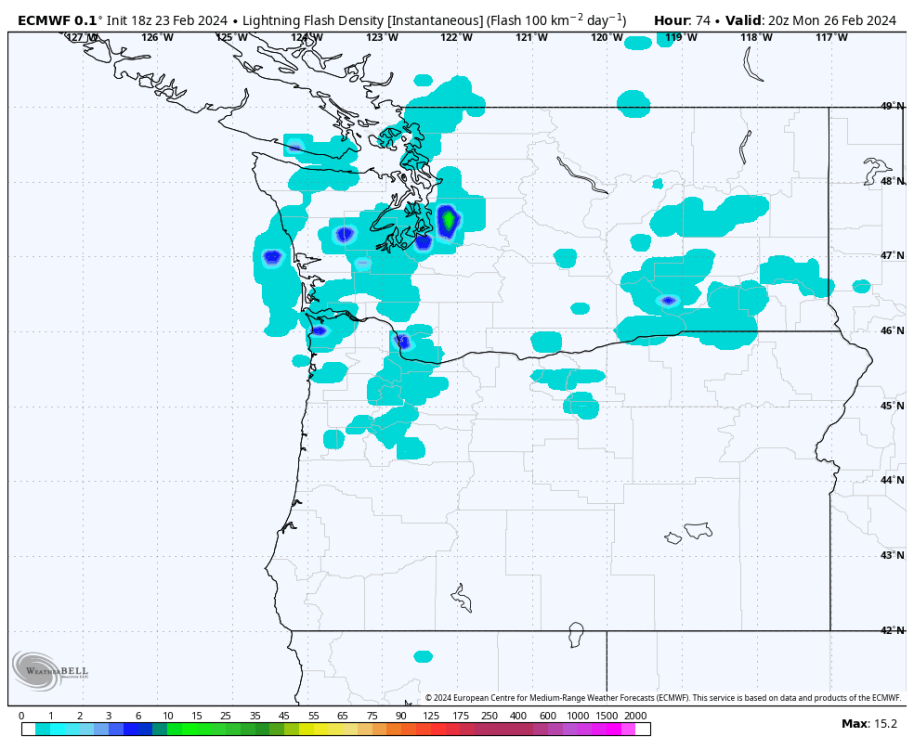
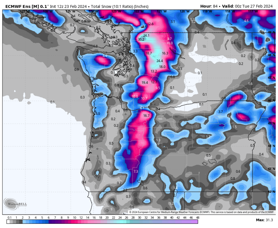
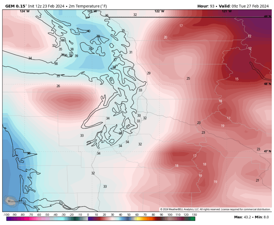
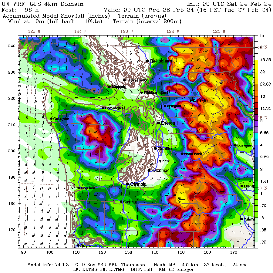
It’s pretty funny what the snow maps are spitting out. Gotta come back in 10 days and see how much measurable snow Sea-Tac actually gets, if any.
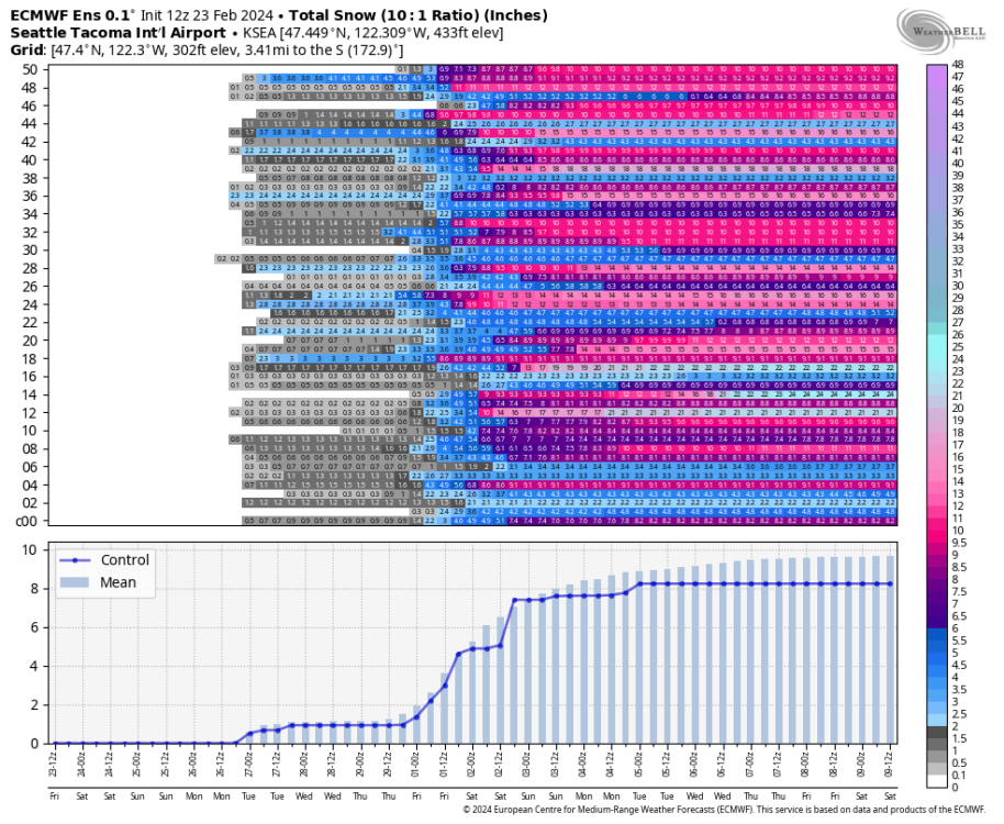 8 points
 -
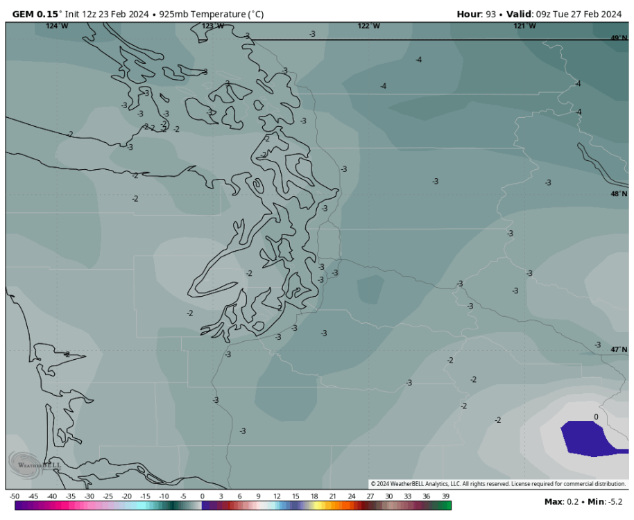
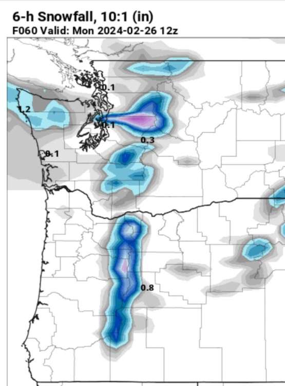
Good lord! Run to run change vs the 12z.6 points
-
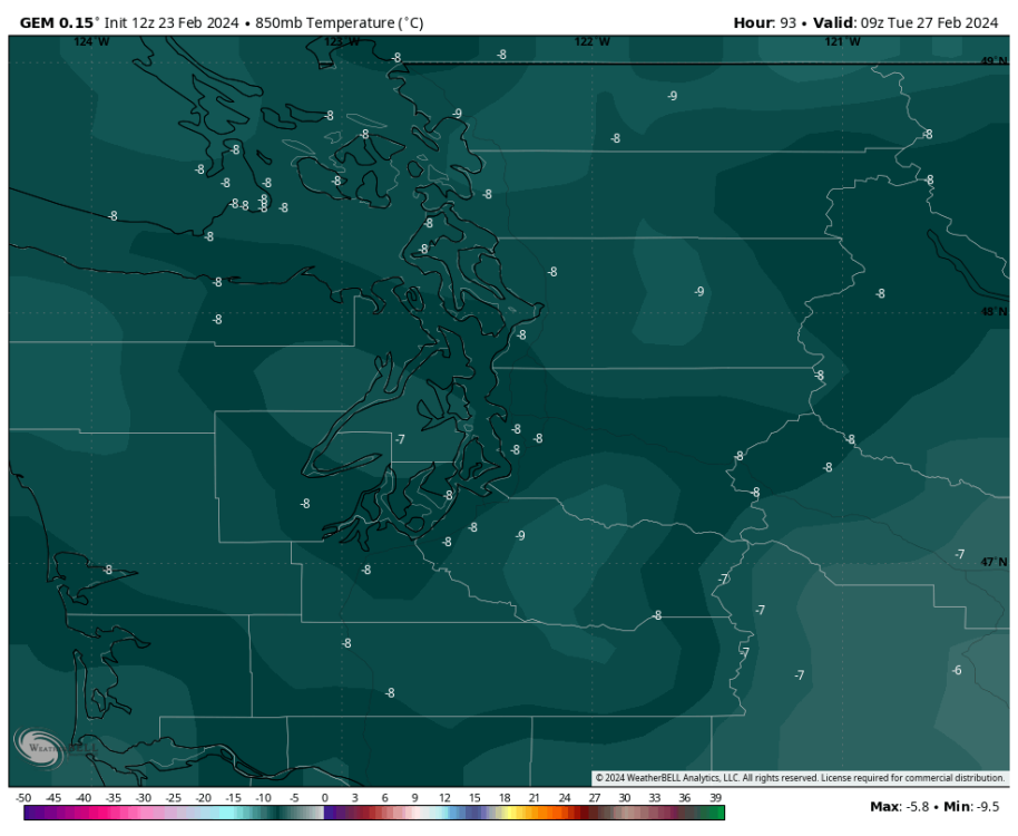
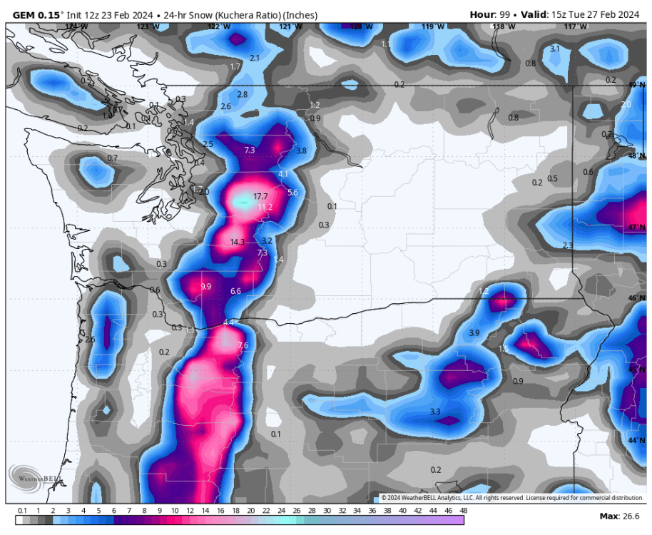
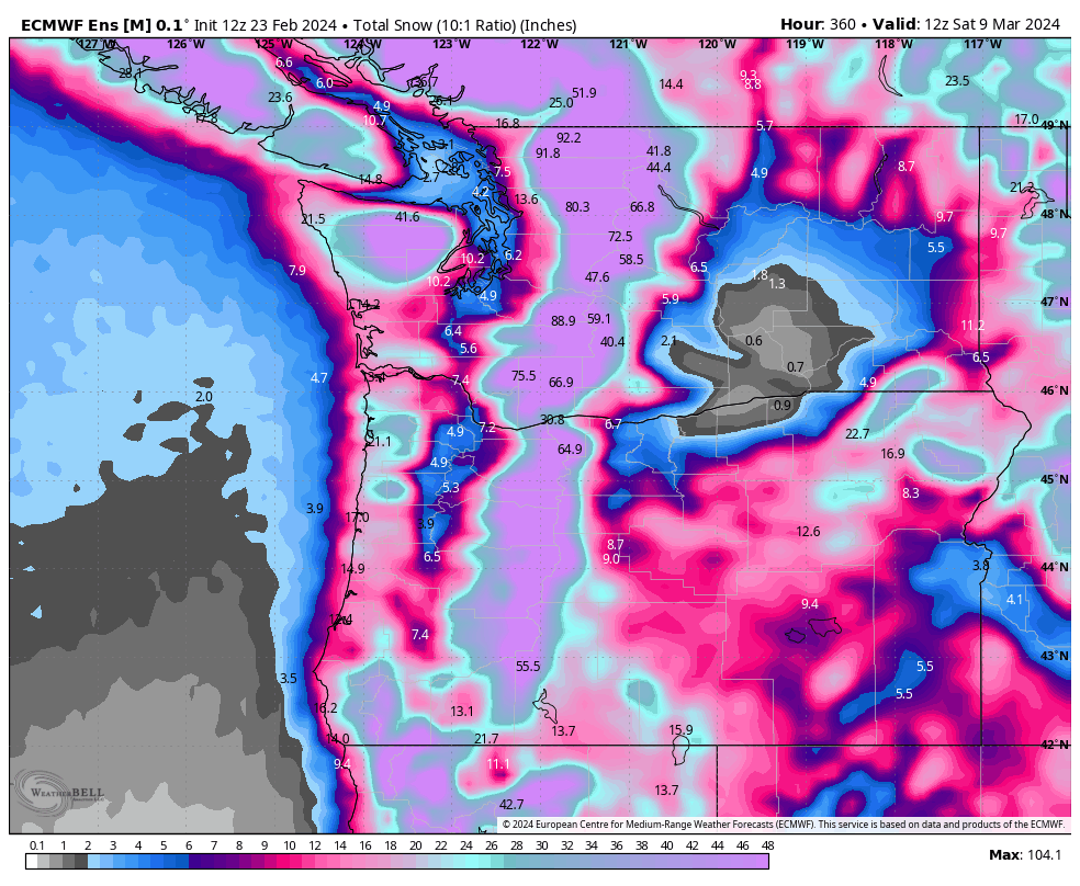
Nice euro run for western WA. MossMan bullseye once again.
 6 points
 -
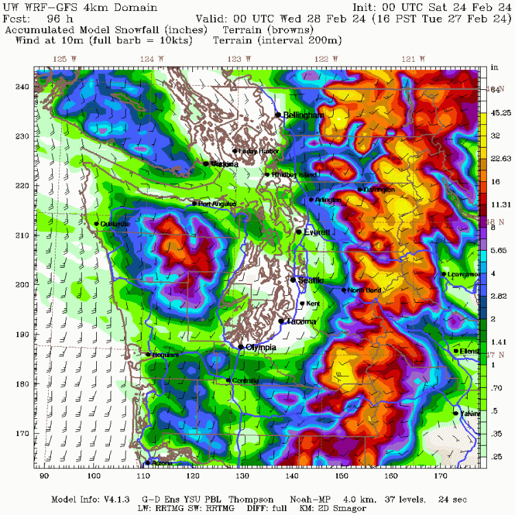
CZ's can be quite dynamic in terms of snowfall. I was living in Seattle in 1996 on Capitol Hill and the forecast called rain snow mix possibly. Well a CZ developed and it appeared to be a King/Snohomish County line special. As the CZ began to slide south, it strengthened and stalled over Seattle. We had a howling northerly wind and ended up with over 10 inches of snow!6 points
-
Sounds nice. I have heat lamps set up all over southern Vancouver island to force spring flowers and tropical plants upon us all. 18z smashed My Area with a heavy snowstorm next week.
 6 points
 -
18z gfs has many chances for lowland snow again through the period, especially the favored areas.6 points
-
The meteograms show a foot of snow for SEA over the next 10 days.6 points
-
Really solid cold here.6 points
-
I am at peace. Whatever happens will happen.6 points
-
My brother in Christ, onshore snow is the primary way we get the stuff after mid February.6 points
-
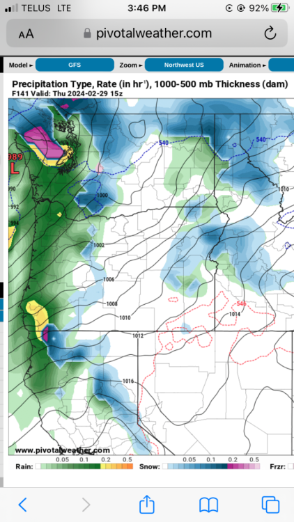
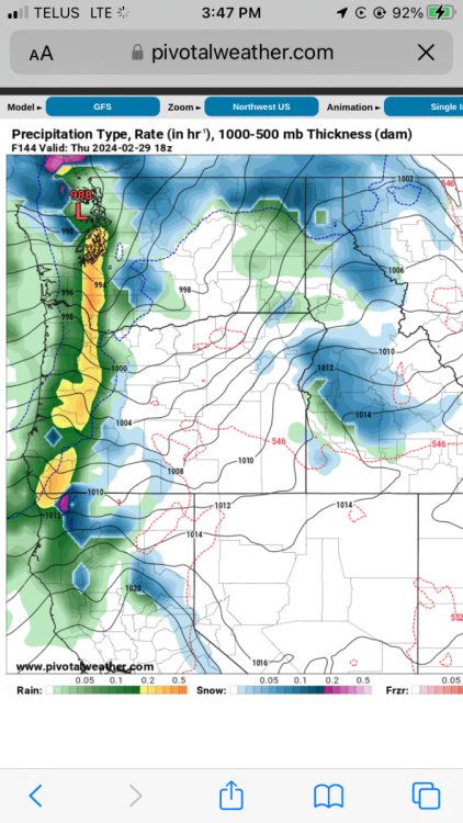
UW-WRF still not a fan but better than 12Z in most areas. Tomorrow the WRF ensemble will be in range. Agreed that the models are likely underdoing the CZ potential.
 5 points
 -
Lightning potential for sure.
 5 points
 -
I'm trying to practice Matt's signature stoic equanimity but watching snowmap after snowmap roll out hole'ing me to death with an Olympic mountain range-sized club is starting to get to me... The best lift will be to my immediate north and south, and best thermals 500' up. It's been no coincidence that nearly every scenario has resulted in paltry totals for this little corner of Pseattle. Not that Lake City needs an Achilles Heel, but NW onshore flow is a pretty damning 'snowfall setup' here, if you can call it that. It takes advantage of every wonderful weakness this neighborhood has to offer; Olympic shadowing, low elevation, unfavorable PSCZ placement. Unless we get lucky and luck out on the latter of the three, there's not a whole lot to look forward to until the backend of the trough when overrunning takes over.5 points
-
I currently have a cat that I don't want to even think about losing someday. A fluffy orange Maine Coon and she is so sweet.5 points
-
One of these was taken on today's date in 2015. One of these was taken in June of 2021.
 5 points
 -
So sorry to hear this. My condolences to your family. I just hugged my dogs extra tight.5 points
-
18Z ECMWF looks quite snowy for King County on Monday night.
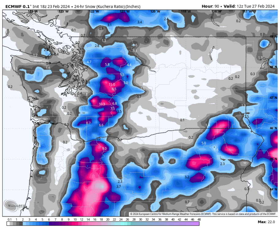 5 points
 -
11 members on the 18z GEFS are below -8 on March 1. There has also been some cooling on the first trough since last night's 0z run.5 points
-
What a beautiful day! Was having my walking break at work and there’s no clouds at all.
 5 points
 -
Big changes on the 6z ensembles with the second trough. Considerably further east than 0z runs. We'll see if that continues on the 12z runs.5 points
-
The snow is still there for this area Monday evening. At least it looks like a decent chance here. Nice to see early Tuesday morning a lot colder than the 12z.4 points
-
Pscz nails me! I think models are probably undergoing strength.4 points
-
4 points
-
Thundersnow! Being convective would make frozen precip a lot easier to achieve.4 points
-
This is the only problem with pets, we get very close to them and they just don't live long enough.4 points
-
This is a first ever?4 points
-
At this point we have the 12z GEM, 12z ECMWF, and 18z GFS with a good signal for snow in King County Monday evening. We shall see.4 points
-
Any sub-40 high in March is serious bidness. SEA hasn't had one since 2009.4 points
-
Through Monday evening
 4 points
 -
The ECMWF does bring back some King County snow late Monday afternoon and evening.4 points
-
This will work for EPSL Monday night

 4 points
 -
Solid cold signal for this far out on an ensemble mean.4 points
-
It’s been a really good stretch. I’ve averaged 40.5” per winter between 16/17 and 22/23. If you include this winter so far my average has been 38” per winter over the last 8. Pretty good stretch historically.4 points
-
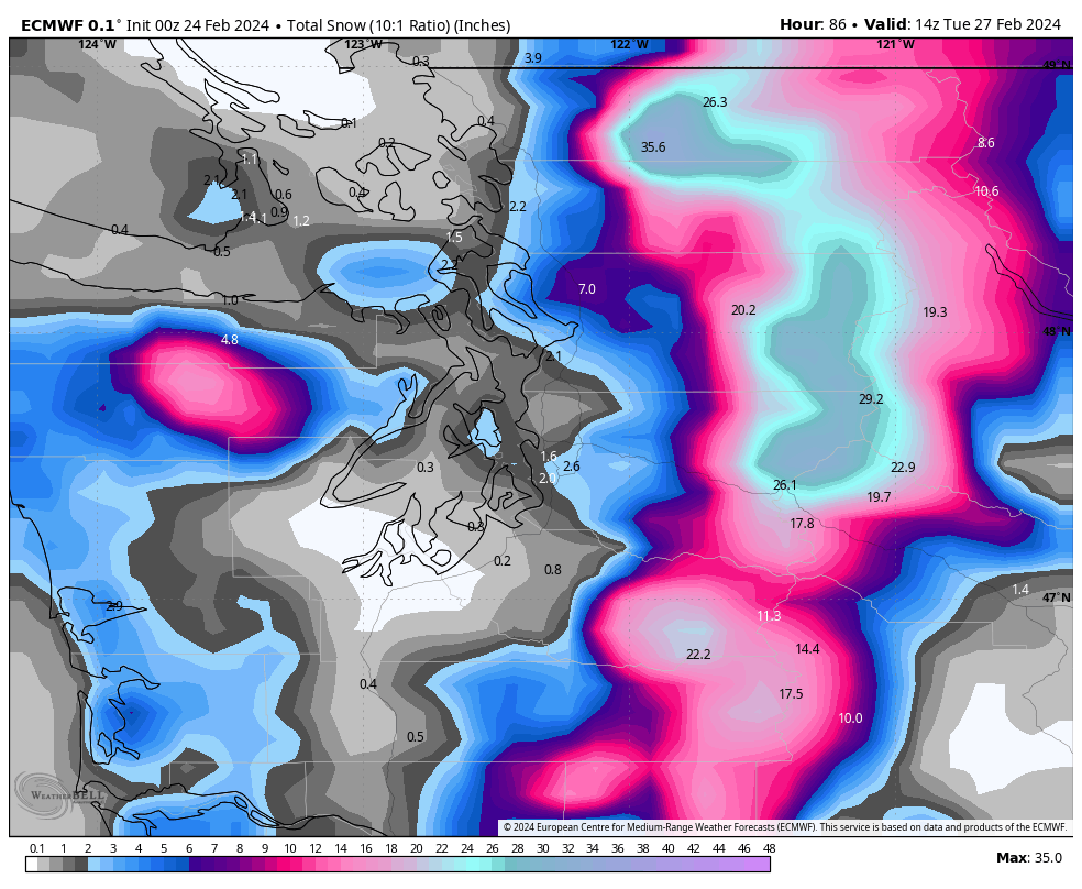
Incredible euro run.3 points
-
Big eastward shift with the second trough. Should mean a colder outcome if correct.3 points
-
A true 34F rocking here. Probably lightning too with that setup.
 3 points
 -
7 is a lucky number IMO. Definitely gonna snow now.3 points
-
Ended up with a 61/33 day here. Hard to believe a year ago today there was close to a foot of snow on the ground, screaming east winds and highs barely reaching 30.3 points
-
What’s it like up there, sitting back with your arms smugly crossed , shaking your head as the rest of us paste eaters actually follow the weather? I think that might be Matt’s box seat you’re in, btw.3 points
-
Btw I’m loving your call for a 2010 like progression these next few months @Phil3 points
-
Idk egg guy said it isn’t happening3 points
-
No longer looking great for my area. I’m going to take down the Christmas lights today.3 points
-
King County does well on this ECMWF run. Some decent cold later in the run too.3 points
-
Mid levels look cold enough for sure. Surface temps are shown in the low 30s by sunset.3 points
-
I'd really like to believe it.3 points
-
33 and a few flurries currently. We hit 50 again yesterday. 60 in the forecast this coming Monday. At this rate I'm ready for spring. Daylight is longer and it's almost March already. Gonna be a hot summer if this pattern doesn't change.3 points
-
This is a big change from the 00Z run... much more favorable for King County.
 3 points
 -
3 points
-
There are more signs of below average temps showing up for weeks 2 and 3 of March and snow for the north and western members of the sub. The JMA has been consistently taking the MJO into phase 3 but with no support from the other models until now the GEFS, CFSv2, and CMET have joined in and the Euro is slowly adjusting that way. The EPS starting to take on a snowy look for some in the extended and this mornings GFS has quite the storm around the 9th which would line up with the LRC as a very wet storm should move across the sub in that time frame. 5th -9th GEFS this morning. Winter probably has 1 last gasp3 points


.thumb.jpeg.e3014abf99ef08a9f9ac2c0cd31b485b.jpeg)


This leaderboard is set to Vancouver/GMT-07:00