-
Who's Online 36 Members, 1 Anonymous, 220 Guests (See full list)
- Snoorani
- summerrules
- mtep
- TT-SEA
- Tony
- bud2380
- BLI snowman
- Hawkeye
- markjb
- marquamhillberries
- MossMan
- Beltrami Island
- Ellsworb
- Cfweather
- Ray
- Jonnypopper
- Hawkeye1
- james1976
- Vmod30
- moosieman
- weatherwonder
- Maple
- SouthHillFrosty
- wxisthebest
- Bedonbye
- badgerwx
- Port Angeles Foothiller
- SnowWillarrive
- JeepinWX
- AndreSunshine
- Stacsh
- SE Nebraska wx
- Canadian guy
- andrewr
- WildWisconsinWeather
- ShawniganLake
-
Activity Stream
-
27
Winter Storm: 3-15 - 3-16 Potential
Looks like it trended slightly north overall -
1168
March 2026 Weather in the PNW
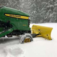
38 and drizzle! Still some snow that fell off the carport left!!!!!!!! -
1168
March 2026 Weather in the PNW
Google's weather app at my place. Must be based on the GFS because it also shows rain/snow for Phil tomorrow. -
364
March 2026 Observations & Discussion
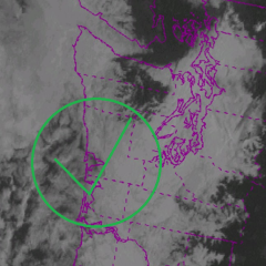
Whoa! What a crazy stormy evening yesterday throughout KC, big hail and some funnel clouds, and more rain. It's literally middle of April here with things blooming and the grass so green and growing. Crazy early start to spring. I pulled some live traffic cams up near Omaha and westward, they had a nice coating of snow this morning. 70's and 80's to snow cover. Happens every year. Maybe more snow to my north this weekend, looks like a big one for some of you. For KC, a very strong cold front and maybe some snow showers Sunday. Might hit the teens for lows Monday morning.- 1
-

-
27
-