
Leaderboard


Popular Content
Showing content with the highest reputation on 01/06/16 in all areas
-
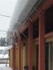
At my second stop of the day for work after leaving Pasco, this is in Ellensburg. Some crazy icicles from the snow slowly sliding off that roof!
 2 points
 -
January 6 has been an unofficial first day of spring for awhile now, before mid winter's annual return in late February. Happy birthday!2 points
-
I appreciate your posts tracking events like these. Keep it up!2 points
-
Couple looks at 12z Euro - dynamic system - can't say "zzzzz-fest" Which model will be 1st to sniff cold air coming into play??2 points
-
The WRF. He also peed in the cold pool.2 points
-
Ready for some football? Seahawks and Vikings will face off in the coldest on record. ( I love the website. Very appropriate. The Daily Norseman ) "After looking at three different sites. . .Weather Underground, Accuweather, and The Weather Channel. . .the forecast for Sunday is now significantly colder than it was. While we were looking at temperatures in the 12-degree range yesterday, the current forecast for Sunday shows a temperature at kickoff of anywhere from +1 to -1 degree." http://www.dailynorseman.com/2016/1/5/10715802/nfl-playoff-weather-where-we-revise-the-seahawks-vikings-forecast1 point
-
Winter is taking a break, it will return starting March 15th and last thru July 5th. That is when we will have a -4PNA with awesome retrogression to 150!1 point
-
There's a pile of snow on either side of my shop about 6 foot deep. 30X40 shop with 17" of snow on the roof.... All of it fell off today. Snow is falling off the house too and I'm glad because there was ice dams all over. Gutters are torn to piss (idk why the heck someone put gutters on a place here). Oh well, I plan on getting some corrugated 12" pvc pipe and making my own temp gutters that I can remove in the winter...1 point
-
Feb 14 we sat under the most amazing comma head I've ever experienced. Gave us 8" of our storm total of 14". Was my first winter on the subforum. Same year as the amazing run Chicago had.1 point
-
So we would respond to him1 point
-
Want to use some science to back yourself up?1 point
-
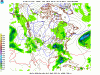
Pretty sweet graphic here depicting the Split flow and storm train riding into Cali...
 1 point
 -
-NAM and STJ increase??1 point
-
At least the last 4 runs on the NAM it keeps showing more snow on the NW side...nothing crazy but baby stepping...1 point
-
Looks like 4-6 for Chicago this run. Def. trending stronger and stronger each run.1 point
-
Great insights Tom! Globals against the American models attm. Gonna be quite the ride following this, eh? This is the battle we've talked about for a few months now - Nino vs the blob with the low solar to boot. Battle ground setting up with us smack dab in ground zero like you said.1 point
-
This system should be getting partial sampling in tonights 00z runs....full sampling by tomorrow's 12z runs...even then, once the energy skirts the 4 corners region we will see some interesting runs. That -NAO is going to help this storm turn due NNE. Haven't seen a Greenland block like this in a while. Those rising heights in SE Canada are going to help slow this system down and dig. Also, the Euro has been weakening the 1st wave and focusing in on the stronger gulf wave which allows the energy to focus in and eventually phase quicker. On the 12z Euro run, the model is still seeing a piece of energy just NW of FL which effects the storm phase earlier. If this comes out of the Gulf in one piece, its going to be a massive storm IMO. This may just be the model "dragging its feet" and leaving energy behind. I don't see why it would do so. Future runs will probably have this energy in one bulk piece.1 point
-
Status Quo for us means no snow. His point is unless the graphics indicate something different for us why did you post it. Most of us have no idea what the graphic means. I found it interesting. It's been a long time since we've had GLAAM graphics posted here with sensational text affixed to it.1 point
-
Status Quo for us means no snow. His point is unless the graphics indicate something different for us why did you post it. Most of us have no idea what the graphic means.1 point
-
Not going to argue this with you, but this seems like semantics to me. If that's not NPAC blocking, I don't know what is. And regardless of the NAO, that's the kind of blocking that usually delivers cold air to the PNW.1 point
-
1 point
-
Honestly if it is really means normal status quo for us I am not sure why you are posting it here??? Not sure what your point is???1 point
-
It's a bummer that we have the arctic air building to our North, but will be neglected due to a strong jet and Aluetian low. Our best hope is a relaxation of the jet, allowing cold air to spill south a bit, but that doesn't look likely anytime soon with the MJO over the Pacific. In a typical weak ENSO year, we could count on a jet retraction and Aluetian high (downstream trough over west) as the MJO reignited over the IO and shifted into the Maritime region in a couple weeks, but this year is very different. Strong stagnant ENSO conditions (convection/upward motion over the Pacific and suppression/downward motion over the Maritime) will cause the MJO to break down as it approaches the Maritime region, which would benefit the west. The break down is due to upper levels not supporting the convective / thunderstorm nature of the propagating wave. All in all, everything is working against us right now, but I suppose you never know!1 point
-
If only you were 20 today! Happy DOB.1 point
-
Not 100% sure, but looks like pink dashed would be 32*F at 850mb, and solid purple 32*F at 2m? Prolly gonna dynamically cool with hvy wet snow bringing surf temps down quickly..1 point
-
We'll be incredibly lucky to see 33 degree rain the rest of the winter, let alone snow.1 point
-
Happy Birthday!!1 point
-
Happy birthday Jesse. I hit 40 this year so enjoy your younger years.1 point
-
Over a decade now for me. When I started I only had one kid, Dewey was barely two years old, Jim was ridiculously confident about the winter to come and Tim was mowing his lawn with kitchen shears. So much has changed. Happy birthday!1 point
-
Welcome to the 30s.1 point
-
Glad to see the Euro trending this storm towards the Lower Lakes! Great maps Jaster and Geo's! What does the snowfall map look like? Also, seems like the Euro is phasing this beast much earlier than prior runs. Classic bomb setup. Bizzard not out of the realm of possibility? 30-Day cycle theory in play here.1 point
-
Good god, you're old. Weren't you like 12 when you started posting here?1 point
-
Low of 30 on my 30th! #firstdayofspring #wintercancel1 point
-
Goodie more 35 degree rain. Can hardly wait!1 point
-
12z UK revving it up pretty good, albeit way too far east for Iowa to get anything. http://img.meteocentre.com/models/ukmet_amer_12/GZ_D5_PN_096_0000.gif1 point
-
Has some juice to it for sure.
 1 point
 -
Also in this case -NAM benefits California more-so than +NAM under strong W-HEM +AAM/+EPO.1 point
-
I figure most people who post here have internet access.1 point
-
27 here this morning with some icy roads left behind from a shower that moved through late in the evening.1 point
-
Latest (nowcast) CFSv2 run for January...looks like most of the Nation below normal...what happened here??? Debacle... http://www.cpc.ncep.noaa.gov/products/CFSv2/imagesInd3/glbT2mMonInd1.gif1 point
-
00z Euro def trending NW and has a 992mb SLP in N OH at HR 108...doesn't wrap around any snow on the cold side of the storm though. Still plenty of time as this thing is showing signs of what could be a major storm as the jet buckles1 point
-
The plates and dishes are on the table for a major event--- exactly where they are placed and who sits where is yet to be determined.1 point
-
Getting closer. 12z euro was way out east and nearly OTS.1 point
-
1 point
-
I know its the 00z NAM, but taking a look at the 500mb vortex at the end of the run looks promising for lower lakes cutter. Storm starts developing in N AR and the GOM starts opening up. This storm has a real good chance of becoming a TX Pan Handle hooker (no, not the one on a six corner in Chicago...lol). http://www.tropicaltidbits.com/analysis/models/namconus/2016010600/namconus_z500_vort_us_29.png1 point
-
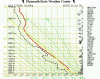
Generally these soundings are just a brief snapshot and don't capture the best dynamics for us, which tend to be pretty fleeting. The July 22, 2000 thunderstorm outbreak for example was triggered by a shortwave moving quickly up the coast. The 00z sounding at SLE on 7/22 was relatively impressive But as you can see, 24 hours later those dynamics had completely shifted north. Like with snow, it's a very delicate balance for us in getting the right combination of elements for warm-core thunderstorms. There's always going to be a fine line between an encroaching cooler, stable marine layer and the warmer, moist unstable air. These conducive elements generally don't last too long, although in a less progressive pattern an event like August 1999 can happen where areas do see storms several days in a row.
 1 point
 -
Another 1.
 1 point
 -
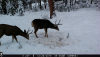
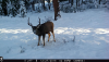
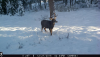
I set up a game camera at my property to see what i could get on film. Very nice buck.
 1 point
 -
I see the moon...a little clearing which is allowing temps to drop some. Down to 30.4 Calm wind though. Pretty out with 2/10th inch of ice or so.1 point
-
I'm liking this January so far...average high of 35.9, average low of 21.4. 1.5" of snow today. Right now heavy sleet with the occasional flake. A few pics. The roads aren't bad yet, luckily the snow came before the sleet and freezing rain.1 point


.thumb.jpeg.e3014abf99ef08a9f9ac2c0cd31b485b.jpeg)


This leaderboard is set to Vancouver/GMT-07:00