
Leaderboard


Popular Content
Showing content with the highest reputation on 01/29/17 in all areas
-
NAM is purdy. We might just get spoiled.4 points
-
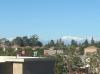
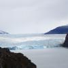
Frozen Snake River today Cap Cloud on Mt. Hood The rugged Mtns of Central Idaho3 points
-
Here is the picture
 3 points
 -
18z NAM shows the deformation band pretty well here http://www.tropicaltidbits.com/analysis/models/namconus/2017012918/namconus_ref_frzn_nwus_45.png http://www.tropicaltidbits.com/analysis/models/namconus/2017012918/namconus_ref_frzn_nwus_48.png http://www.tropicaltidbits.com/analysis/models/namconus/2017012918/namconus_ref_frzn_nwus_52.png http://www.tropicaltidbits.com/analysis/models/namconus/2017012918/namconus_asnow_nwus_29.png3 points
-
Month to date. Very impressively cold month over both Oregon and Washington. At least we have all been sharing the love with the cold!
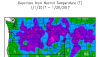 3 points
 -
You mind posting the map?2 points
-
Yeah, hopefully. Although the learning curve for "being a president" is probably pretty different from the learning curve for "being a narcissistic yet successful real estate mogul with inherited wealth"2 points
-
540 line all the way down by Eugene.2 points
-
2 points
-
If this happens it just goes to prove the atmosphere does have a memory of sorts within a given season. Really weird how even finer details can repeat after a complete reset.2 points
-
You may need to start a new sports thread. This one has been overrun.2 points
-
I fully expect highs in the low 40s with sunshine. I'm sure TT will post pics of flowers.2 points
-
Today ended up being dry and breezy so it was perfect for a nice hike!
 2 points
 -
I agree 100%. It's incumbent upon the administration to make sure this doesn't continue, but it's happened on a very small scale thus far. If people are using it simply as a means of political leverage or to further an alarmist argument then they are just part of the overall problem.2 points
-
Could be a reasonably solid cold shot. The 12z ECMWF shows 850s dropping to -7 now with some Fraser outflow. Maybe one or two days with highs in the 30s. I would say lows upper teens to mid 20s on the one or two coldest nights depending on wind speed and cloud cover. You can't say we haven't had cold this winter.2 points
-
But in the end, actions really do speak louder than words. Even for presidents.1 point
-
No doubt. He's not used to feeling such backlash at every move...he'll either learn and adapt, or implode.1 point
-
I've been hoping for that period to trend better. The best run I've seen yet in that time frame.1 point
-
We still might eke out a overrun event sometime Thursday evening ~ Friday. It's starting to look like the BC lower mainland might be a winner again with that one.1 point
-
It took a lot of time to dig up data (two of my biggest hobbies are mountain and weather), but I revised and expanded the Fact Sheet Interesting Weather Statistics for US Mountain Summits: http://www.summitpost.org/interesting-weather-statistics-for-us-mountain-summits/171585 Added were a Mt Spokane in eastern Washington; Mount Fanny in the Blue Mountains of Oregon; White Mountain Peak in the White Mountains of California; Mount Baldy in the Wasatch Range in Utah; Blowhard Mountain in southwest Utah, not far from Zion National Park; Berthoud and Fremont passes as well as Mount Evans, all in Colorado; Grandfather Mountain and Mount La Conte in the Southern Appalachians; Haleakala on Maui in Hawaii; and Mount Locke in Texas. Also, since it came up on another thread, I was able to do some digging on the Mount Rainier data. Apparently there have actually been several studies on the summit climate of Mount Rainier, dating back to at least 1960. Some studies used actually data and some interpolations. The latest study just ended in 2016 and the page has a link to it. I hope that you find it interesting.1 point
-
I would love to see a spring featuring cool / dry weather and lot of frosty nights. Those can be enjoyable.1 point
-
I suppose the next window of opportunity could be different due to changing wavelengths and whatnot. I think we will have one more shot to get it right.1 point
-
Low around 33 in morning to high around 76 this afternoon.1 point
-
Things are starting to look good. After hour 84, there is more snow coming. http://maps1.pivotalweather.com/maps/models/nam/2017013000/084/refcmp_ptype.us_nw.png1 point
-
I think his tweets are a big deal. they indicate that he speaks without thinking, which is a terrible quality for a president to have.1 point
-
Didn't take long for them to pull out the 1/10/17 analog!1 point
-
Too easy1 point
-
Sure. If it's an issue, it needs to be dealt with. But I don't know how the reactions of the last couple days can be fairly considered a proportional response. It sets a very unrealistic precedence for freakoutedness. Eventually those who are not dug in so deeply against this administration will tire of this constant barrage of outrage.1 point
-
Just into a house 6 blocks away so still in Mountlake Terrace. My apartment complex raised my rent $200 so I told them I was out of there. Found a room in a house for less than half as much money and the plan is to save for a downpayment on a house possibly as early as this Summer. The new place is 100 feet higher though. Maybe it'll make a difference!1 point
-
Again, things that were very apparent in October. Nothing he has done in his first eight days are a surprise.1 point
-
I think all of the blocks have been too top heavy to favor snow for the Seattle area this winter. It's just not conducive to the details working out properly for us. Once we lose the high surface pressure to our WNW it really hurts our chances in most cases.1 point
-
Yeah the 12z GEM was also showing a deformation band over PDX on Wednesday, now we just need the EURO to get onboard. I think this event will be more widespread than the last one. Models are showing moisture eventually making it's way to the Sound, so I like their chances too. http://www.tropicaltidbits.com/analysis/models/gem/2017012912/gem_mslp_pcpn_frzn_nwus_13.png1 point
-
I miss seeing puget sound posters. We see a few of em here and there, but nothing like we used to1 point
-
Looks like another seasonably chilly day on tap down here. This has been a really enjoyable month.1 point
-
It can be great for your panic levels.1 point
-
Who puts frosting on a cake after it's been cut?1 point
-
The winner is likely going to be someone who stays in the -1c to -3c ballpark at 850mb, so very marginal at that level. Models tend to underdo deformation in these setups and these weak boundaries do tend to be very stubborn and slow-moving, so I imagine somebody will score 6" or more from it with a fairly prolonged event.1 point
-
We have Portlandia. Seattle hasn't had a major show since Frasier. And his apartment wasn't even physically possible.1 point
-
Thank you for your honesty. Up until now I assumed you wished only horrible things for our neighbors to the north.1 point
-
I honestly wish the Puget Sound region could have scored something this month. It kind of sucks experiencing the best January in years regionally and realizing that everyone up north will forever refer to it with bitterness and vitriol since, by purely dumb luck, it failed to snow in the relatively narrow corridor that is of utmost importance to so many. Just a slightly better setup (a degree or two colder up there) on 1/9-1/10 would have made all the difference in how this month was viewed by Sounders.1 point
-
http://www.tropicaltidbits.com/analysis/models/gem/2017012912/gem_asnow_nwus_20.png http://www.tropicaltidbits.com/analysis/models/gfs/2017012912/gfs_asnow_nwus_25.png 12z NAM is fairly generous with pushing in the cold air fairly far south. Does show some light snow in the area by hr78 before the main precip. 850mb temps are really marginal on all models though.1 point
-
You will probably get a sloppy foot in early March.1 point
-
It'll probably snow next week.1 point
-
Apparently none of WFO's upstream are buying it's heavier totals there? Zero watches anywhere. At least the portrayal of highest amounts over SWMI looks better. Finally picking up on a boost from the lake. Yeah, especially this month. And here she comes!1 point
-
Looks like I have a good chance at passing 5' this season with the snow this coming week.1 point
-
@Jaster, You must be getting some light to moderate snow now per radar standards. Any accumulations so far? Btw: my area is looking at 3-6inches with tomorrows clipper. Sweet!1 point
-
You still must have frozen fingers with how bad your grammar is.1 point
-
Supposedly 30.98" in Ontario Oregon today.1 point
-
Additional papers if anyone is interested. Long term ENSO variability: http://www.sciencedirect.com/science/article/pii/S0012821X04007083 Long term Niño state during last glacial maximum precedes end of ice-age, mid-Holocene Niña state precedes cooling. Thankfully, the latter hasn't yet coupled and amplified, though it shows signs of doing so. http://adsabs.harvard.edu/abs/1999GMS...112..373C Tropical convection as a trigger for rapid climate change: http://www.sciencedirect.com/science/article/pii/S0012821X05002190 Goes to show how unstable the system actually is, and that a mere change in global convection/circulation can alter the planetary energy budget and global climate substantially.1 point


This leaderboard is set to Vancouver/GMT-07:00