
Leaderboard


Popular Content
Showing content with the highest reputation on 10/21/23 in all areas
-
It’s coming.
 9 points
 -
Cold lows9 points
-
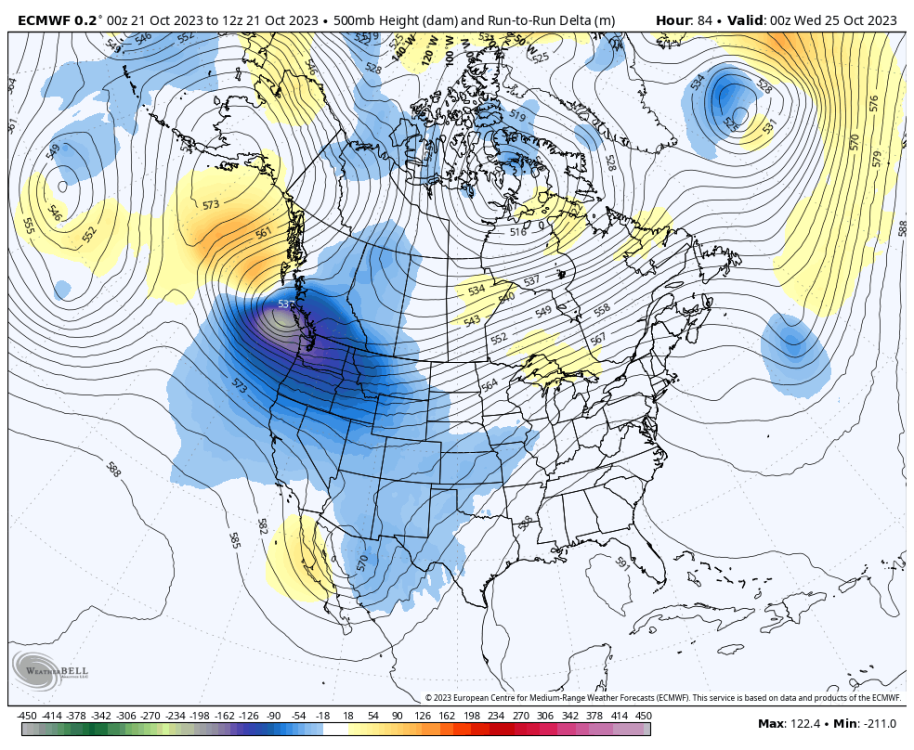
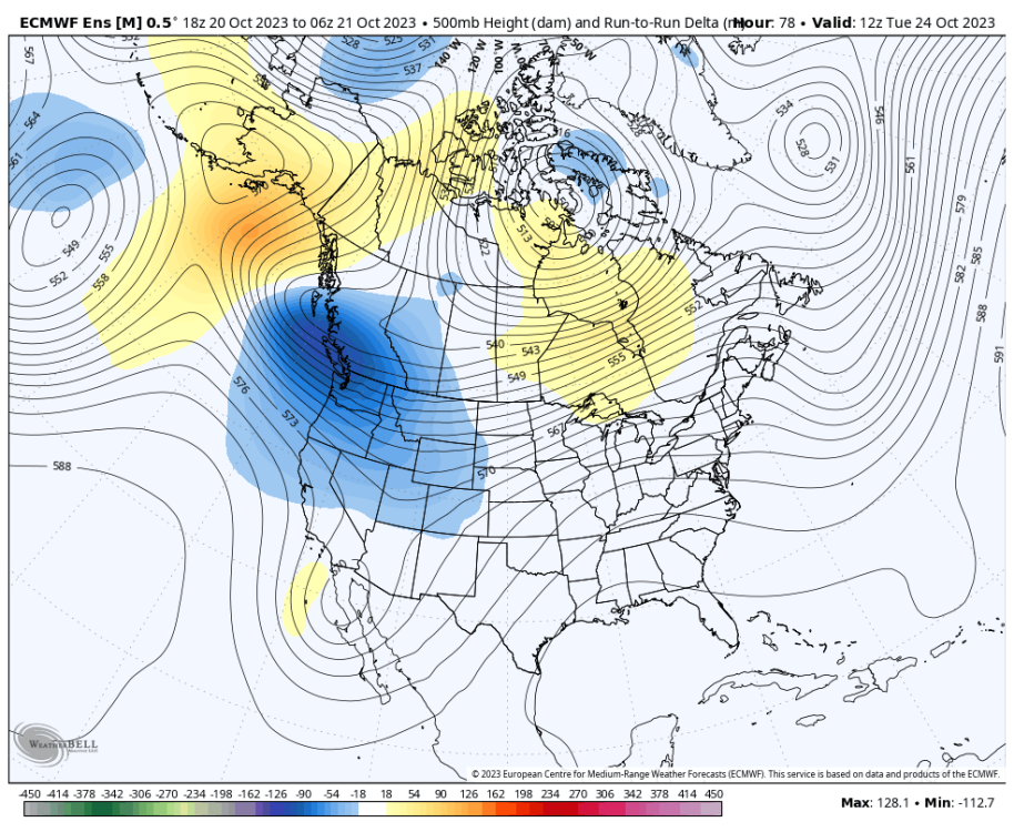
Total cave by the ECMWF to the GFS.
 9 points
 -
12z GEFS is surprisingly bullish on a cold end to the month. Most of the “warm camp” members gone on this run. Will be interesting to see what the 12z Euro shows. The 06z Euro doesn’t go out very far but it looked like a step toward the GFS.
 9 points
 -
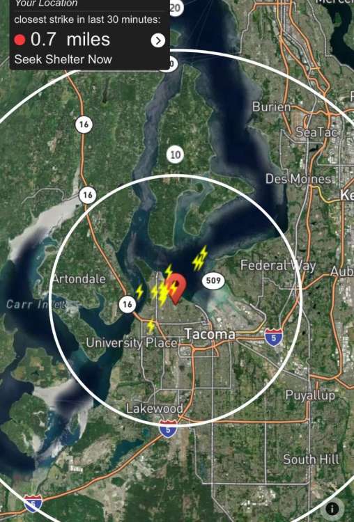
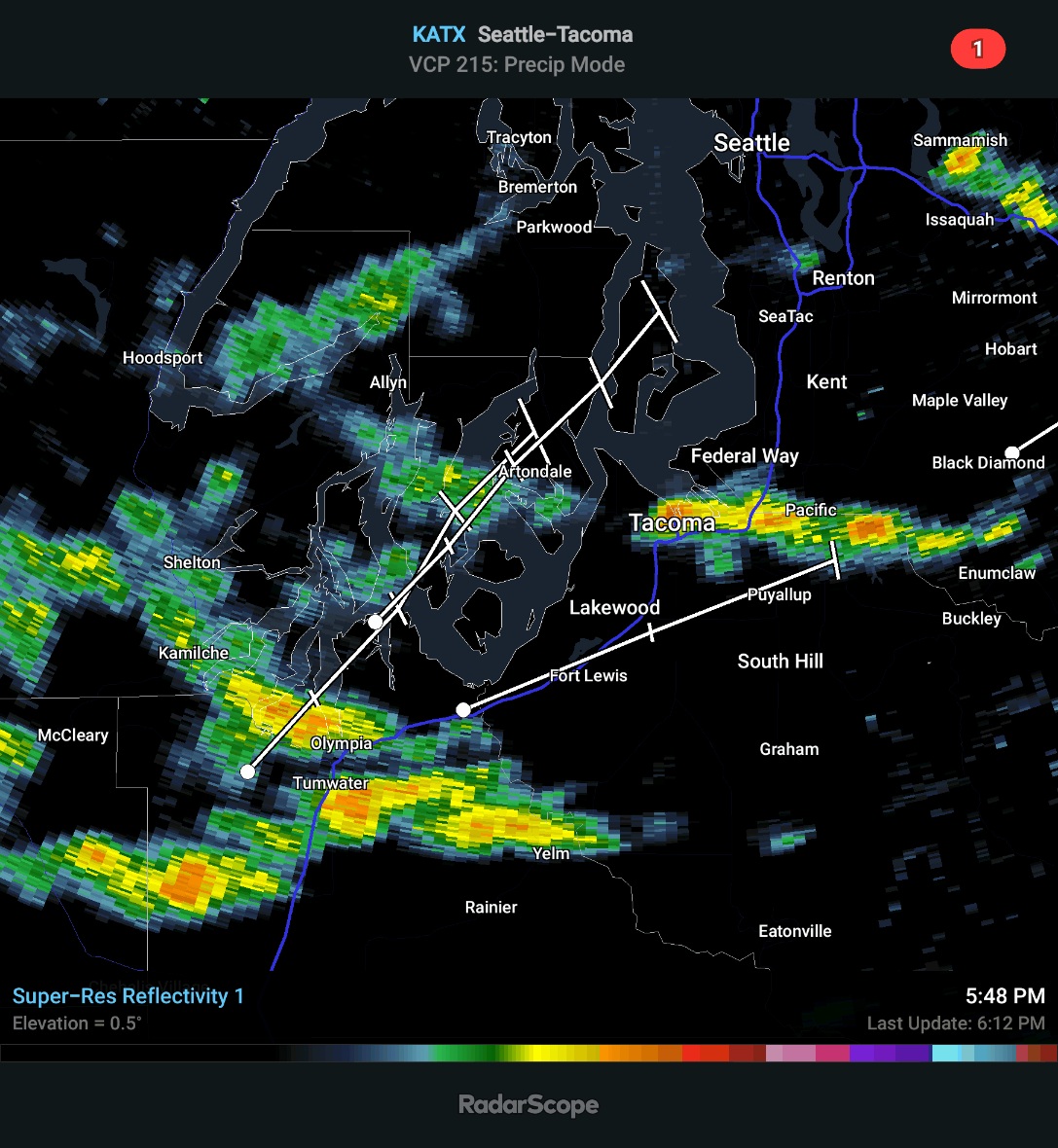
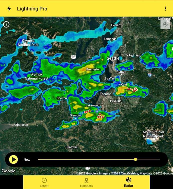
Just had a big boom of thunder here a few minutes ago.8 points
-
Yep, surprise thunderstorms out this way as well!!7 points
-
And another one!
 7 points
 -
Even the EPS is caving to the GFS.
 7 points
 -
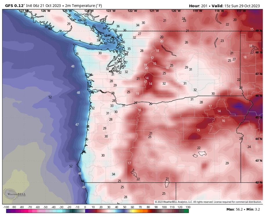
GFS showing a chilly morning on the 29th also.
 7 points
 -
Several flashes and thunder here in the last couple minutes. This is the most interesting the weather has been here in awhile.6 points
-
I thought I would post the thunderstorms up in the Seattle area.
 6 points
 -
Thunder offshore, too. Rare to get midlevel thunder this time of year.6 points
-
Always like checking point forecasts in Montana and Wyoming this time of year.
 6 points
 -
That’s on you6 points
-
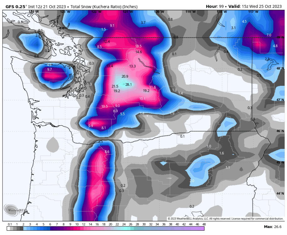
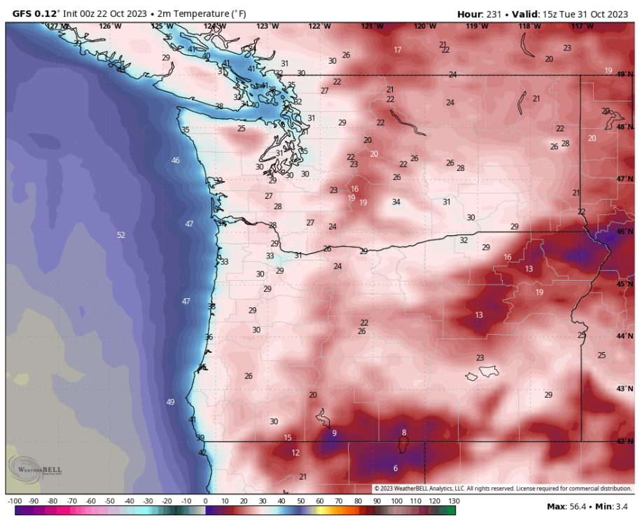
GFS has been impressively consistent. Hard to say it did not win this model battle. 12Z run shows some lowland snow within 96 hours.
 6 points
 -
Hey! I see JIM!!!! @snow_wizard!!!!!!!
 5 points
 -
Could be some of earliest sub-530 thicknesses on record…5 points
-
Gone all day fishing and hiking. It was nice up in the Cascades of Clackamas County. Cold. 33 and foggy around 8 AM, but it warmed up nicely after. On the way home it was very thick fog at Government Camp and heavy drizzle from Zigzag to east Gresham real ugly stuff. I just looked at 12z runs. Did the Euro cave to the GFS? It sure looks like it. Interesting. That's a chilly trough. 00z GFS in 12 minutes5 points
-
Thunderstorms on top of a marine layer is one of those west coast weather things that is unique, weird, and really cool. Who in their right mind would look outside and think the atmosphere is favorable for thunderstorms today?5 points
-
Midlevel convection!5 points
-
Highs around 50 with full sunshine next weekend per the 12Z ECMWF.5 points
-
Day 4 Day 5 Day 6 Day 75 points
-
Day 1 Day 2 Day 35 points
-
Originating from the Comet IP/Halley, also known as Halley's Comet, the Orionid meteor shower peaks across the Northern Hemisphere every October. This year, the peak activity happens on Oct. 21, offering the best chance to see the meteors in action.4 points
-
Time to look west if you're in downtown Seattle. Got a storm popping up.4 points
-
My favorite of these setups is when the marine layer itself convects. It's a super rare phenomenon that usually happens only on the coast range, but in our most dynamic setups, parcels at the top of the marine layer/PBL become viably buoyant, and may even be lifted. Or, in the late Spring/early Summer when the marine layer is really starting to take shape and mixing is strong, trapped fingers of the marine layer, particularly ones deep within the mountains of the costal range where cool valley air is trapped easily, can be transformed into humid/warm parcels via surface heating, and can lift naturally due to uneven terrain/heating, and the low buoyancy of water vapor relative to N2/O2/CO2.4 points
-
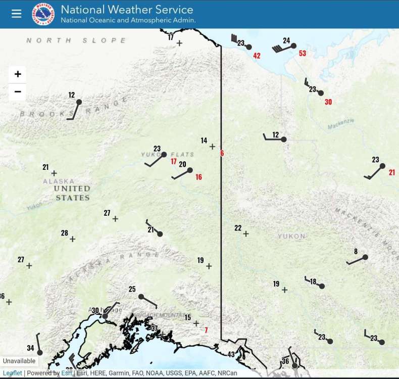
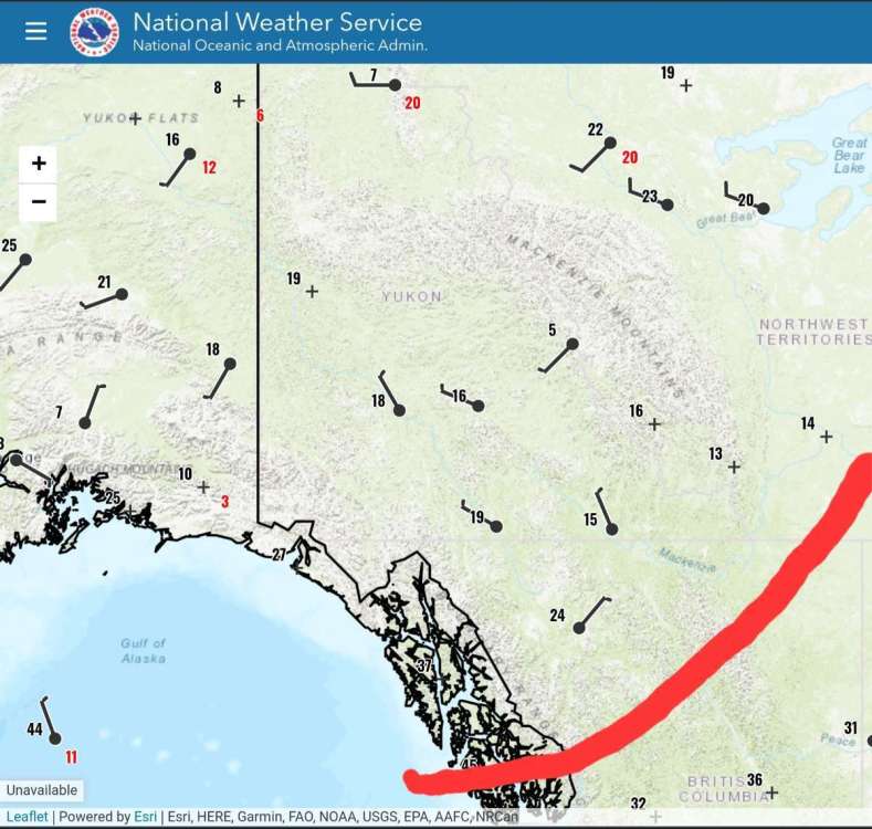
Just thought I would post current temperatures up in Alaska
 4 points
 -
The amount of geese flying south seems to indicate the GFS will be right4 points
-
Just heard one again here too4 points
-
Another rumble of thunder just now.4 points
-
It was loud enough to wake me up from nap, definitely did not expect that today.4 points
-
Starting to look like I could see some sub-50 highs and my first freeze next week. Pretty nice to see.4 points
-
Yeah I had no idea either. Thought it was some explosion or a loud truck at first then I checked the radar. No rain just thunder.4 points
-
It keeps getting better for me…
 4 points
 -
Gorgeous. Loving the super early snowmaps for my house this year.4 points
-
4 points
-
Every time I see @Slushy Inchit reminds me of why I avoid whiskey when trying to get frisky with the wife.4 points
-
The Euro wants to bring the remnants of Norma right over mby and also holds the main energy in the Pacific NW back and bring it out with a deep trough over the middle of the country. Long story short the 0z Euro was awesome run if you want some moisture over the next 10 days. Further more the way it handles the energy out of the NW would lead to a major winter storm and artic outbreak in future cycles. However with the 3 major models we still have 3 completely different solutions. Euro at hr 138 and hr 216 GFS same hrs Canadian is want different4 points
-
Chilly morning on the 29th per the EC tonight.
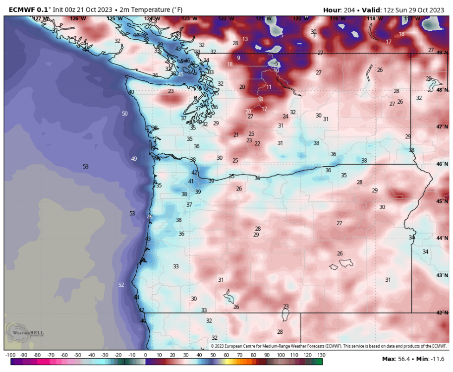 4 points
 -
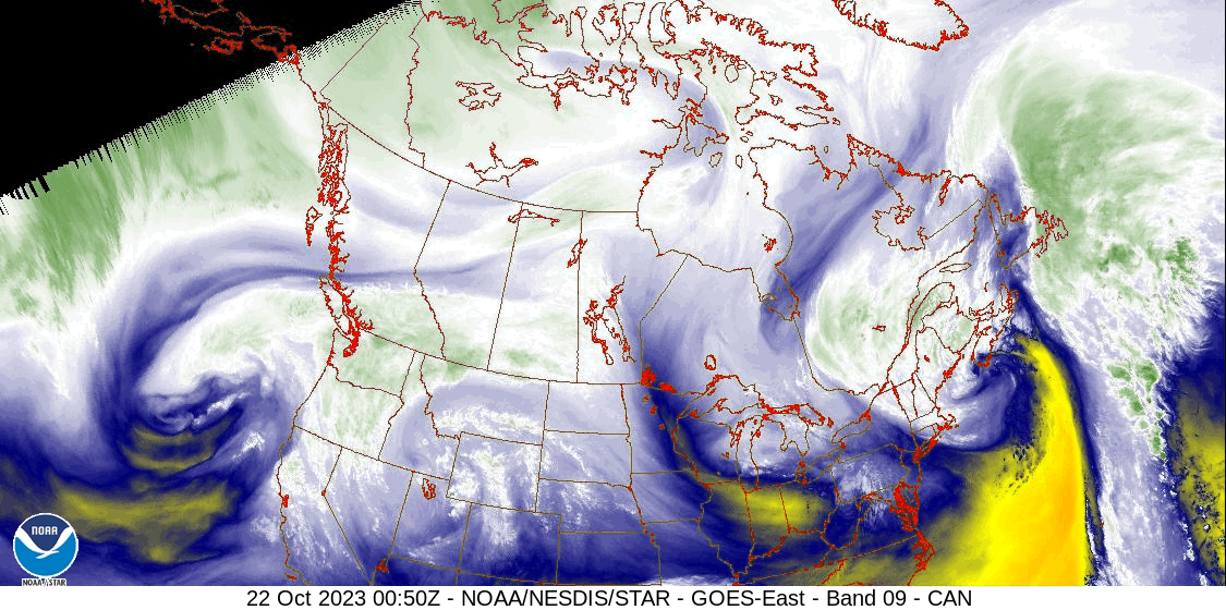
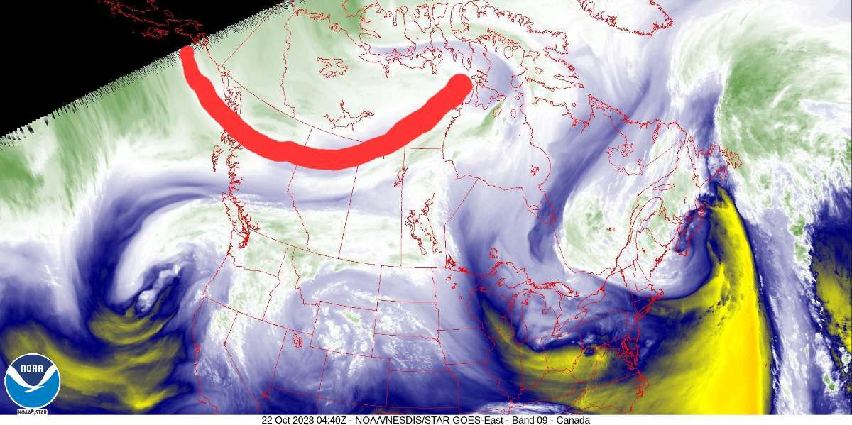
I wanted to look for the cold air up in Canada and I think I found it. I downloaded a GIF of the mid-level water vapor satellite picture but took a still shot and drew a line where I believe the colder air is. I then looked at the temperature map and drew a line like the satellite picture and look what I found. Some really cold air. It's filtering down our way. I don't think our area will get that cold like it is up there but I think we will feel a bite in the air, especially in the mornings. The 00Z GFS looks good still, let's hope the Euro looks the same

 3 points
 -
Some frozen pumpkins on this run!
 3 points
 -
It is interesting how the radar hasn't really shown much, but been getting a lot of drizzle and light rain through the day here. I love the drippy weather.3 points
-
Thunder here3 points
-
Major flooding event earlier in November, then the huge windstorm a few weeks after the big snow!3 points
-
I got the notification of lightning and I was surprised. I didn’t think anything noteworthy was going on today.3 points
-
Yeah. If that's true, guess I'll enjoy this one while I can.3 points
-
The record for +70 days in a month before the last 2 years was 2014 (5). We had 12 in 2022 and 6 this year. Many years since 2005 where we haven’t hit 70 at all.3 points
-
Every time I log in here I regret it.3 points
-
If this were a month from now I would have already peed a little.3 points


This leaderboard is set to Vancouver/GMT-07:00