
Leaderboard


Popular Content
Showing content with the highest reputation on 11/10/15 in all areas
-
By the way. I got engaged on October 29th, and it was my future wife’s idea to have our engagement photos done in the snow at Mt Baker... Keeper?9 points
-
This would be quite a pattern for this winter.2 points
-
I can't imagine this storm actually tracking like that, but my god. What a powerhouse! Haven't seen anything that strong in my life, not even in fantasy land. Good to see the cold air being wrapped around it as previous runs didnt have it. I think it has some serious potential, and we're all in the ballgame for it. I truly think Western Nebraska could be the Hotspot for the next month. I'll ride with you Jeremy, because if that pans out it would be "biblical"2 points
-
Agree, this region tends to see the biggest storms early and late in the season. It's about time they get some active wintry weather. Hope the trends continue down the road.2 points
-
That was one of the weirdest looking storm paths and progression I've ever seen. I got real excited when I saw the low come out of southeast Colorado and had all that cold air to work with....... But then it never really makes it to eastern Nebraska. Low moves due north and then northwest and weakens. True cutoff. Might have to get a hotel room out in western Nebraska to enjoy this one if that actually verified!2 points
-
12z GFS back with an insane cut-off blizzard Day 7-9 in the Plains...LOL2 points
-
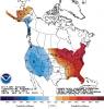
Looks like ENSO 1+2 region is done warming according to the CFS. The bottom map definitely shows this el Niño is a bit more central based. Not a textbook Modoki el Niño, but more of a hybrid.2 points
-
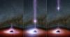
First time ever observed. http://www.blastr.com/2015-11-4/nasa-just-saw-something-come-out-black-hole-first-time-ever
 1 point
 -
Pattern is going to be loaded...I think some of us will be experiencing a White Thanksgiving this year. I'm going start winterizing my house this weekend and put away all the hoses, etc from outside. Winter is around the corner buddy!1 point
-
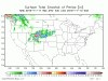
It is impressive. This system goes negative tilt and phases very quickly. The exact opposite of 3 winters ago. Snowfall map from pivotalweather
 1 point
 -
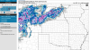
4km NAM looks kind of scary in the mid-Mississippi River valley when it comes to severe weather. Supercell signatures on projected radar composites. Everyone should check this new site out: Pivotalweather.com Some really great maps/graphics in there.1 point
-
New NAM still a bit colder in Central Nebraska. Painting some 2-4 inch totals. GFS has been a bit warmer. NAM has been consistent though so something to watch for. I'll take NAM over GFS for short term accuracy any day.
 1 point
 -
GFS is actually showing something similar. Haha1 point
-
DGEX! DGEX! DGEX! God bless the DGEX. The most overblown model in the history of models. http://www.emc.ncep.noaa.gov/mmb/mmbpll/dgexops.conus/eta.totsnow192.gif1 point
-
It could happen again in a month.1 point
-
That's exactly almost what I'm looking for this winter.1 point
-
Looks like PDX's high of 49 today will be their first sub-50 high since February 1.1 point
-
East Asian Theory looks to turn stormy/colder as we close out November. Another rather vigorous system is poised to hit Japan in a SW/NE fashion over the next 7-8 days. That part of the world turns real cold as Winter settles in near Japan. http://www.tropicaltidbits.com/analysis/models/gfs/2015111018/gfs_mslpa_wpac_34.png This would bring implications for inclement weather around Thanksgiving and continue into the early part of December. There was a powerful storm that hit the Bearing Sea a few days ago and using the Bearing Sea Rule, it would also imply on a colder/stormier Thanksgiving week somewhere in the central CONUS. It's fascinating to see that both theories (East Asian Theory & Typhoon Rule) are both correlating a similar pattern at a given period of time even though they happened days apart . Ol' Man Winter will be locking in his fury!1 point
-
I love weather history. The more we know, the better we can be at figuring out what comes next.1 point
-
Both GFS/Euro are hinting at an arctic shot knifing down the leeward side of the Rockies Day 9-10. If this storm can somehow phase with the northern jet, could be real interesting late next week. Might have to follow the AO index carefully if it can play ball. 18z GFS still showing snow in the Plains...1 point
-
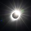
This looks cool
 1 point
 -
Not sure where to put this, but for anyone following the "solar chill": https://www.rt.com/news/273169-solar-cycle-ice-age/1 point
-
Well, the last several years have had a similar ring to them pattern-wise, right? I predicted similar events in 2012-13 and 2014-15. Obviously, there were complications in the latter case (which are in fact unique to that year). To rehash: We failed to achieve SSW/PV breakdown in 2013-14 and 2014-15. Both ended up roughly similar, minus other explainable variances. We did achieve the SSW (full flow reversal, in fact) in 2012-13, and subsequently observed some of the most prolific late-winter high-latitude blocking on record.1 point
-
12z Euro with a similar cut-off low next week but it's track is more due west/east and intensifies into a 992mb SLP near STL Day 8. 850's marginal in the Midwest, but in NE/CO/N KS there is snow potential. Edit: Another big precip/wind producer...1 point
-
Many places in SW BC saw their first freeze of the season this morning. 31F here. 30F Abbotsford. 26F Campbell River.1 point
-
We've seen the models paint huge and unrealistic totals on and off over the past few winters. Having said that, the front range of CO got that 42"? bliz in Oct '97 (NINO!) and Rapid CIty and the Black Hills had that system dump 2-5 feet. It's the land of massive spinners, so who the heck knows? Maybe it's Nebraska's turn. Nature has a way of balancing out and they've been the moisture futility zone in recent years.1 point
-
Tom, I need to breath. I saw that and about fell out of my chair. If only part of that verified I would be pumped. I don't ever remember a map showing that much snow in Nebraska, even over 384 hours. That is just crazy. Good eye candy to look.1 point
-
True. I think JAMSTEC did a pretty good job with that one as well. There are just too many cold signals to ignore. I think January and February could be ridiculous.1 point
-
Full blown hybrid with forcing at 180*. Forecast to dissipate from east to west so will lean modoki by midwinter, west based by spring.1 point
-
And wet enough1 point
-
I think our best shot at snow this winter will be when it's cold enough.1 point
-
Blocking would be in favor, since solar activity is super low. A hard freeze again this morning with a low of 27°. My Japanese Maple put on a color yesterday. Tonight it is bare.1 point
-
Hopefully we can have a few very wet years. We desperately need it.1 point
-
Winter Storm watch posted for the Cascades.1 point
-
The thunderstorm moving up through the Sound just gave Gig Harbor a crazy hail storm. Looks like snow: https://www.facebook.com/scottskomo/videos/1069522769734306/1 point
-
Umm, because of the elevation. Jeeeeze, follow along would you!1 point
-
Just hope we get to see something like this soon. I took this 12/8/2013...1 point
-
Pretty amazing sunrise this morning! Just enough high and mid level clouds ahead of the incoming system to put on a colorful show1 point
-
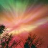
Hi all: It has been about 2 years since I last posted to the forum. During this period I retired and moved to Santa Fe and now to Cheyenne from Portland, OR. Anyway, I have created a lot of cool time lapse videos Astro-photographs: http://www.astrobin.com/users/NightSky/ and my collection of Northern Lights Photos: http://latitude64photos.com like this: http://vimeo.com/136069744/ that you might enjoy. Anyway, I hope to contribute when something interesting weatherwise or otherwise happens. Regards, PRISM1 point


This leaderboard is set to Vancouver/GMT-07:00