
Leaderboard


Popular Content
Showing content with the highest reputation on 01/02/16 in all areas
-
I'm happy for you folks down in Portland. I just want to see some snow in Seattle for a change.2 points
-
LOL, anybody forecasting widespread accumulating snow based off of yesterday's model data would ultimately look pretty damned stupid 99.9% of the time. Yay for us if this turns out to be the 0.1%.2 points
-
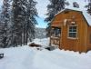
Went back to my cabin and snapped this pick thursday night about 5 miles from my place. Today we had a low of -10 and a high of 5 lol.
 2 points
 -
just got real http://lmgcorporate.com/kptv/weather/ibs_web_7-day.jpg2 points
-
Ironically, January 1993 never had a traditional Arctic outbreak.2 points
-
Starting to look like this might end up being the January without a summer.2 points
-
Wow, Seattle has already tied last years minimum and also tied for total snowfall!2 points
-
Haha - I'm only a consumer, not a buyer / seller / trader unfortunately. I checked back. Those posts I remembered were from the first week of November. Some of the ones you made look spot on if the next (10) days plays out as anticipated. Where did all our marshmallow roaster posters go now that it's chilly out?2 points
-
Sure could have used these dew points last Sunday...2 points
-
Why in the hell would you want to cause region wide panic?... Just plain silly!!2 points
-
That trough has definitely been trending to the south west over the last few gfs runs. Still very far out though.2 points
-
NWS Seattle should really be posting some frost accumulation advisories! Getting thick on my deck rail!
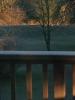 2 points
 -
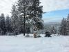
Heading to Bend for a snowshoe trip today. Should be absolutely gorgeous over there.2 points
-
But did you hear it might warm up eventually? Don't you even think about enjoying this!!2 points
-
Sprinkles/light ice pellets tomorrow afternoon. Prepare now.2 points
-
What if it goes east or west?2 points
-
Without a doubt. Well played2 points
-
I am just throwing this out there, but these kind of deformation patterns can turn far wetter/snowier than expected. They have in the past.1 point
-
I heard recently and repeatedly around here that Mark is all washed up. Pretty suspect forecast. Hope he's right.1 point
-
NAM, ECMWF and GEM and now even the GFS are showing higher precip amounts with the GFS saying that there will be a warming slot above freezing around the 800-900mb level. All others say it will stay cold enough to support all snow through the afternoon hours.1 point
-
I think it's safe to say at this point pretty much everyone will at least start as snow.1 point
-
2-4" looks like a distinct possibility...Looks like deformation between the ULL to the north and the other to the south is why moisture is increasing on past few runs...1 point
-
I am thinking of making a frostman tomorrow...1 point
-
Went to Omaha for a Christmas yesterday and today. Very jealous of their snowpack. Good 6 inches or more on the ground in a lot of places. As you go west, very little in Lincoln, a little more towards York, then it dwindled down to almost nothing in central Nebraska. We sure need a share the wealth storm.1 point
-
JB said coldest nationwide over a 5-10 period.-- not regionally. (from today's video) Didn't mention anything about last two winters-- at least in todays video,, don't know what exactly he is comparing the 5-10 day period too...Guy takes a lot of heat-- many times from people who twist his words..1 point
-
I agree and I LIKE this An error occurredYou have reached your quota of positive votes for the day1 point
-
With an established snow pack already in place, one would think the operational models should trend farther south... http://www.nohrsc.noaa.gov/snow_model/images/full/National/nsm_depth/201601/nsm_depth_2016010205_National.jpg It paid dividends with the last storm, should work again with this one.1 point
-
Liking the GEM solution more for the day 7 system. Teleconnections support a more west to east track. Quite a few solution on the table. I'll take this.1 point
-
18z GEFS look very similar to the 12z EPS... http://www.tropicaltidbits.com/analysis/models/gfs-ens/2016010218/gfs-ememb_lowlocs_us_26.png1 point
-
Last winter was awful as warm and uneventful as a winter can be. To me it fell into the 91-92' nightmare winter category. This year will not be in that category. I am thankful for that. Looking outside at sunny skies, snow covered ground, dozens of birds eating off my feeders and bird seed it is a great day and I am thankful.1 point
-
It is a cold day. Highs in many of the E. Oregon basins only hitting 8-12.1 point
-
Need it to dig more instead of coming out of OK/KS. Cuts it through Iowa and W. WI in the mid 990's.1 point
-
Lake starting to freeze! Brrrr!
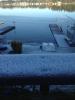 1 point
 -
It would only take a small difference in timing for that bulge of cold air to move a little further west before it heads SW to give us a good Fraser outflow. Either way it is like you say much better than a typical El Nino pattern.1 point
-
We know good and well how much you hate dry cold. That's all I'm saying. I'm sure you would much rather see much above normal temps and gloomy drizzle like we normally have in a big El Nino winter.1 point
-
Won't matter if it doesn't snow. Just wasted cold as usual IMO.1 point
-
That is some beautiful stuff right there. Gotta get a storm under that arctic air somewhere. I think we had the right plays called in the preseason Tom. Nature was just a little slow executing them. Lol1 point
-
Yeah, with that south-southwest digging arctic trough. Might get a significant backdoor blast into eastern Washington. All 12z runs showing this now. Pretty solid agreement surprisingly.1 point
-
Portland NWS thinking about a Winter Weather advisory for the Eugene area.1 point
-
That looks exactly like my deck rail. The depth of the frost definitely eclipses that of my greatest snowfall for 2015!1 point
-
CanSIPS still advertising a wild looking February for much of the nation from the Rockies to the East... http://www.tropicaltidbits.com/analysis/models/cansips/2016010100/cansips_T2ma_us_1.png 500mb... http://www.tropicaltidbits.com/analysis/models/cansips/2016010100/cansips_z500a_us_1.png MSLP anomaly indicating a good probability of a continuation that the LRC's storm track should continue but may shift farther S/SE in time as blocking takes over the pattern. http://www.tropicaltidbits.com/analysis/models/cansips/2016010100/cansips_mslpa_us_1.png1 point
-
Haha makes sense if that were to happen, it's after I leave! Can't check the models at the moment but hopefully Salt Lake can get in on the action.1 point
-
Definite digging trough southwest towards us arctic air steadily progressing south-southwest through BC/AB. That weak low offshore may not stop it, so it could slide down over us, or at least into eastern Washington for backdoor arctic air. http://www.tropicaltidbits.com/analysis/models/gfs/2016010212/gfs_T850_namer_32.png1 point
-
It's important to note that map was at 925mb which is like 2500'? The free air up there will likely mix out, while the lowest levels in the basin and the valleys will stay much cooler and take longer to scour. Not ideal for snow though.1 point
-
22º dp 11º in the West Hills with very gusty winds. I've been getting wind chill values in the low single digits all night and this morning. Be lucky to get out of the 20's today. Fair to say this is more than just "fake cold" at this point.1 point
-
Augspurger 2990' (northwest of Hood River) now down to 13http://www.wrh.noaa.gov/mesowest/getobext.php?sid=BPAUG&table=1&banner=off Wanderer's Peak 4350' down to 9 degrees from 15 at 1 AM. It seems the cold air mass isn't only deepening, but it's spreading/expanding west-southwestward along the north Oregon Cascades. http://www.wrh.noaa.gov/mesowest/getobext.php?sid=WPKO3&table=1&banner=off1 point
-
This could be a good thing. Move the block 100 miles to the west and strengthen it a bit, and you could have the ULL absorbed in the bigger energy of the vortex to return as a glancing arctic flirtation 48 hours later.1 point
-
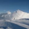
First sunrise of 2016! It was amazing with the snow blowing off of Mt. Hood...1 point
-
Welcome back Tim1 point
-
Cant believe how much snow the polaris will go thru.
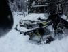
 1 point


.thumb.jpeg.e3014abf99ef08a9f9ac2c0cd31b485b.jpeg)


This leaderboard is set to Vancouver/GMT-07:00