
Leaderboard


Popular Content
Showing content with the highest reputation on 11/16/16 in all areas
-
Best news I've heard all day. The Phil Enthusiasm Index (PEI) has been in strongly negative territory for a few months now. That is a key component of my winter outlook. For some context, the last winter with a very positive PEI (2014-15) was a total dud.4 points
-
Eye candy jet stream carving out a deep trough in the 4 corners region...haven't seen something like this since Feb 2011 GHD-1 Blitz! Let's hope December can open up with a bang. http://www.tropicaltidbits.com/analysis/models/gfs-ens/2016111606/gfs-ens_uv250_namer_65.png4 points
-
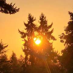
SNOW!!!!!! Okay, it was hail. Covered the streets and ground for quite awhile. I took this pic about 2hrs after the squall passed. Winds gusted 30-35mph as the cell approached.
 3 points
 -
Getting absolutely pounded with hail, heavy rain and high winds here in North Cowichan right now. A really impressive squall. So dark the street lights came on at 230pm.3 points
-
We might just have to settle for a December 2008 but snowier.3 points
-
Frost on the car, puddles are frozen, and a nice blue sunny sky. Roads are (mostly) dry though, so that is nice. Looks to be nice and clear for a couple days. Will be interesting to see if we can get some of the shaded ponds/lakes to freeze. Just finished up the fall season of hockey. Would love to be able to play outdoors for a month until the spring season starts. 27 degrees on my porch this morning. Will probably warm into the low 30s in places that are in the sun all day. Life is good, coffee is good, enjoy your day.3 points
-
Hello gorgeous! Nice to see those words right there..3 points
-
Just booked my flight back to Chicago on the 30th. Hopefully there won't be a snowstorm before I arrive as I'll need to put up my Christmas lights and rake the last leaves! 06z GFS with a crazy blocky run! This pattern forthcoming will be very interesting. CFSv2 trending daily with a central CONUS trough... http://www.cpc.ncep.noaa.gov/products/people/mchen/CFSv2FCST/monthly/images/CFSv2.z700.20161116.201612.gif Can you say....moisture loaded pattern???? Holy smokes! Give me temps in the 20's with storm after storm and I'll be a happy camper. http://www.cpc.ncep.noaa.gov/products/people/mchen/CFSv2FCST/monthly/images/CFSv2.NaPrec.20161116.201612.gif3 points
-
What a beautiful storm shaping up to be. I would like a storm like this right after Thanksgiving, towards the end of the month. Although, putting up the lights will be kinda hard. Speaking of lights, I have to see what day will be suitable. This Friday would be perfect with temps being near record high territory.3 points
-
The first flakes of the year are flying now! Looks like a very intense band is approaching from the NW now.2 points
-
The pattern on the 18z is pretty golden again...Just not much cold air available...2 points
-
It was a lovely sight seeing the snow covered higher foothills on my drive to work this am.2 points
-
Its probably going to be too cold to go skiing this winter anyways.2 points
-
Sure, lol. http://i724.photobucket.com/albums/ww243/phillywillie/Mobile%20Uploads/2016-11/5508C728-A16D-41F6-B44E-B43EB3397CEE_zps6nixtl4i.gif2 points
-
Snowing in Spokane2 points
-
It gets pretty intense around here when we get a storm. There is not much around to stop the snow from blowing around, whiteouts become common place! Enjoy the lovely Arizona weather and have a safe trip back, hopefully you bring us all luck when you fly back!!2 points
-
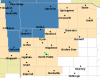
First snowfall map for my area!!
 2 points
 -
I agree with ya! It's too bad this low wasn't further south east, but it's way too early to complain. I'm liking the pattern that is setting up and we should see tons of blocking with a negative AO. I really think everyone will do real good this year. This storm is pretty dynamic, great start to the winter season!2 points
-
Bitter December - January on the way. How much manages to make it over the Canadian Rockies is unclear. Moderate potential of severe cold for WA/OR/ID.2 points
-
Seems like that's the time to watch for a possible retrograde of the main players.1 point
-
Let me check later.1 point
-
Maybe. Hopefully only briefly. PNA fairly neutral, AO, NAO sure forecast to tank now http://www.cpc.ncep.noaa.gov/products/precip/CWlink/pna/pna.sprd2.gif http://www.cpc.ncep.noaa.gov/products/precip/CWlink/daily_ao_index/ao.sprd2.gif http://i.imgur.com/nm8maGg.png1 point
-
Still a +1 departure for the daily mean!1 point
-
December? 39F with moderate rain here currently. Looked like the snow line on the local hills was down to about 2000ft this afternoon.1 point
-
I bet it will all fall into place as the part of the winter that really counts rolls around.1 point
-
I remember marks blog at the beginning of December 2008 had a picture of a pretty bare timberline, and no sign of anything good. Then a week later models went nuts.1 point
-
Didn't take any When I get actual sticking snow I'll get shots. There's always a next time up here.1 point
-
Pictures for the less fortunate?1 point
-
Cold rain at my house!1 point
-
Or colder. And then January 1930, but colder and snowier.1 point
-
November 1985 would be something amazing to see in the 21st century for the PNW.1 point
-
I personally was thinking more about 2010-11 when I saw that. If you overlay December 2010 and this month step for step, you have a really comparable pattern. This year is just earlier than 2010 if it verifies. Had a small tornado outbreak on new years eve night 2010 and 6 days later in 2011 winter came with fury. Similar setup to that transpiring down here starting with the cool front and storms on friday. The PV is absolutely going to be shredded. It's really an epic thing to follow.1 point
-
1 point
-
Joey took a lot of heat from response tweets, but is bullish on this happening:1 point
-
It's not for Nov, so guess I'll show this here:1 point
-
For all that was made of the 2013/14 analog..lol. http://i724.photobucket.com/albums/ww243/phillywillie/Mobile%20Uploads/2016-11/47CC9790-813F-4B8E-8412-45B47D924681_zps8gpdblyq.jpg http://i724.photobucket.com/albums/ww243/phillywillie/Mobile%20Uploads/2016-11/712C9E4E-ECE1-4DCF-8AE5-DA078C2023F4_zpsswo3hkap.jpg1 point
-
I wonder what JAMSTEC is smoking?!1 point
-
You want "convenience wx" I see. Ma Nature should thump your head for thinking like that! Yet again, shafts SC and SEMI on the above normal greens. Nice!1 point
-
Too capped around here for us to get anything near the low. Shame were getting a dry slot, but a good sign that a storm like this is in the area!1 point
-
What are you basing this on?1 point
-
My forecast is calling for snowshowers Saturday night and into Sunday with very windy conditions and cold temps. Highs in the mid 30s and lows in the low 20s.1 point
-
Nice run for sure. The groundwork is laid for something nice as we enter December.1 point
-
To think of it simply... if the PV is strong it has a hard time being pushed around so it holds its ground in the arctic... if it is weak it Has an easier time being dislodged and sent south over the lower 48.1 point
-
We were up in Bay City area yesterday and today and boy was the weather just great! lots of sun and warm temperatures. The highs were in the mid to upper 50's both days we were there. The foretasted highs for Thursday and Friday are in upper 60's well the record high here in Grand Rapids for both days is 70 set in 1958 for both dates. For Thursday there was also a 70 reading in 1953 and there were highs of 69 on the 17th in 1954 and there were readings of 69 on the 18th in 1979 and 1953. In 1958 November ended on the cold and snowy side and the rest of the winter of 1958/59 was very cold and snowy in West Michigan.1 point
-
Im loving the cloudy cold windy forecast. A few snowflakes would be amazing.1 point
-
Great pics my man! That just put me in the holiday mood...(while I am sitting here in AZ with my shirt off on the comp and the A/C cranking cause it's so warm!) Just love all the colors and lights along with a blanket of snow....ahhhhh!1 point
-
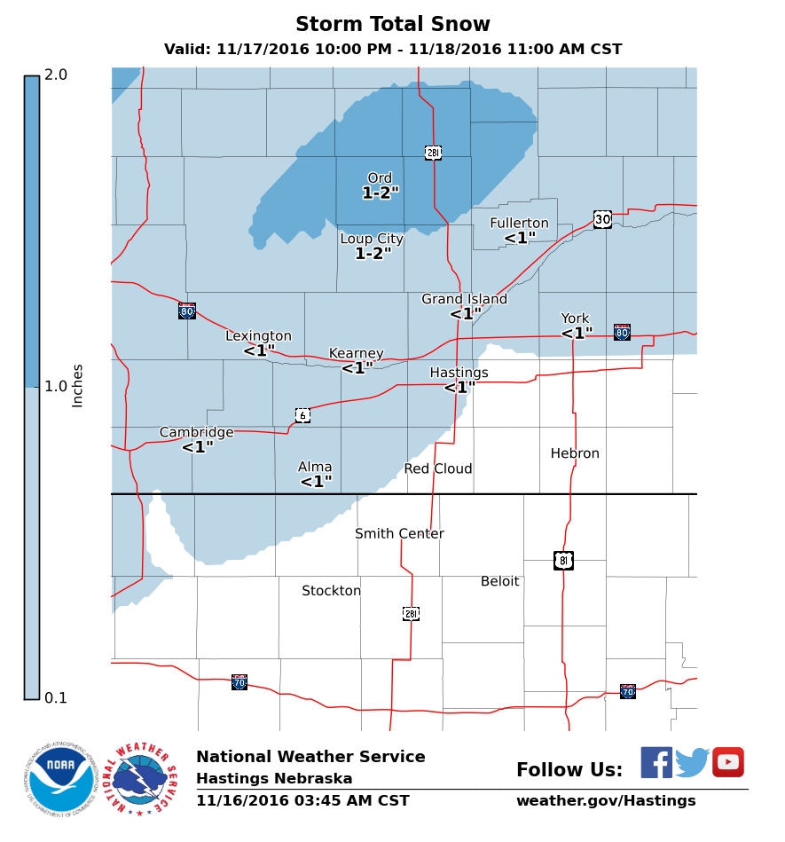
NWS North Platte NE just issued a Winter Storm Watch.
 1 point


This leaderboard is set to Vancouver/GMT-07:00