
Leaderboard


Popular Content
Showing content with the highest reputation on 01/03/16 in all areas
-
Common practice around here5 points
-
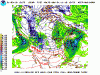
It's lost in all the excitement happening today, but the 12z GFS brings a boatload of very cold air to our doorstep at day 8. Energy also undercuts the ridge around the same time. Lots of snow potential around the 9th-12th.
 5 points
 -
Light snow has started here. Even the ECMWF didn't have anything this early.4 points
-
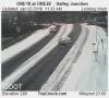
Reporting in.. Just got home from Seattle.. Basically nothing as far as falling snow from Seattle until I got to Hwy 410. Seems to be the snow line here. Snowing moderately all the way up 410 to my house. I have about a half inch or less on the ground. it is currently 35 degrees and very slushy..3 points
-
What a convoluted fuckfest of a pattern next week.3 points
-
Looks like the preface to a car wreck!
 3 points
 -
HOLY MOTHER OF GOD and PANCAKES By far the most bitter air mass I've EVER seen on the WRF! 7:00 AM next Sunday. YES, those are 925mb temps around -35c over south-central BC/AB. AMAZING! http://www.atmos.washington.edu/mm5rt/data/2016010312/images_d2/slp.171.0000.gif3 points
-
12z GFS 6-10/8-14 Day Composite Analogs look outstanding3 points
-
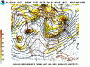
I have to say, at the 500mb level this is probably one of the wonkiest looking snow events we have ever had.3 points
-
Sucks we are getting shafted up north eh?3 points
-
My thoughts and prayers are with you.2 points
-
Smells like it might finally be Whatcom County's turn.2 points
-
I'm liking this January so far...average high of 35.9, average low of 21.4. 1.5" of snow today. Right now heavy sleet with the occasional flake. A few pics. The roads aren't bad yet, luckily the snow came before the sleet and freezing rain.2 points
-
Coming down really nicely now and the ground is beginning to turn white.2 points
-
Jet Suppression!2 points
-
The 12z GFS is freeking amazing! A full blown snowstorm with strong Fraser outflow.2 points
-
Looks like a fairly interesting period of January weather in the mid-long range too. Who would have thought with a strong Nino?2 points
-
Definitely looks to be exceeding expectations so far.2 points
-
iFred is going to be disappointed.2 points
-
gosaints is all snow this run http://maps1.pivotalweather.com/models/ecmwf/20160104/00Z/f120/850mbtempsconus.png 0z last night: http://maps1.pivotalweather.com/models/ecmwf/20160103/00Z/f144/850mbtempsconus.png1 point
-
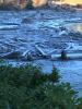
Up to 28 now, continued light rain, a thick glaze on everything, just saw some pictures of Scappoose, looks like a disaster! At this point I hope it gets above freezing but I don't see that happening here or in town until tomorrow afternoon in town and probably not at all here. The problem is up here all the roads are snow packed with ice over them, that should hinder the absorbency of radiation that black asphalt normally gets during the day. I may be stuck up here!1 point
-
I am coming down west side of Snoqualmie and its snowing like crazy1 point
-
The ice accumulations are getting concerning here. It's nearly as thick as the cable line now about 1/2". Trees are bending and worst of all the east wind was just 10-15 G 20 has picked up again past few gusts near 25mph... that's bad news for trees/power outages.1 point
-
Close to 1/4" ice accumulation now. Thin glaze on all the trees. Fairly significant storm.1 point
-
That map even gets that pretty blue color close to my area!1 point
-
Looks like at least 1/3 of the West finished December below normal. Quite a turnaround second half of the month.1 point
-
Yeah it seems like the models are having a very difficult time with this setup. Anything could happen tonight!1 point
-
27 here in Beaverton.1 point
-
Some very slick streets in Salem with the ZR!1 point
-
Airport officially reported 1" of snowfall a couple of hours ago.1 point
-
What a massive disappointment. Still haven't seen a flake down here since Feb 2014. All we got is a crappy layer of very frozen sleet. Now there's some freezing rain. Gonna have to scrape off the vehicle and head to the liquor store soon to drink away my sorrows.1 point
-
Crisis over. Flurry blizzard has ended in the swamp.1 point
-
Not to brag, but I first noticed the cutoff low 5 days ago:1 point
-
12z Euro showing not 1, not 2, not 3 but 4 systems to track over the next 7-10 days...and then there were people saying this pattern is gonna get cold and dry...come on now...patience...I knew going forward that with all the blocking evolving models were going to act funky...they still are. Until this first system enters the pattern, we will see models with a better idea. I bet there are a few on here that thought I was nuts that we would be tracking systems even when the cold hits. There is no way it will get plain ol' cold and bone dry in this pattern, esp the way the Pacific has been on fire. Unless of course, your in the Dakotas/MN/Northwoods where the cold will overwhelm the pattern going forward. I'm also not advising that everyone will be in the best spot...some will, some won't..it's the way nature plays.1 point
-
Light snow and fog here in the swamp.1 point
-
Amazing analogs from the 12z run. 3 from the late Dec and Jan 1968-69 1 from early Jan 1979 1 from Jan 1963 1 from the Jan 1998 cold snap1 point
-
SW BC has missed out also.1 point
-
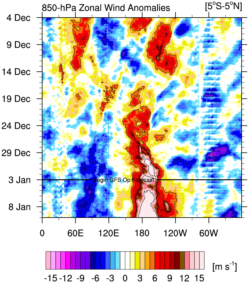
Strongest WWB of the year thus far predicted on the GFS. Might slow down current reversal but due to the nature of the thermocline in a Niño like this, it won't lead to much SST warming.
 1 point
 -
I have a bit of De Javu from Feb 2014 here. PDX getting a nice snowstorm while Seattle gets nothing. Completely different setup and SEA actually did get some snow in feb 2014, but considering there is less precip than that storm it reminds me of a less precip version of 2014.1 point
-
Totally. Pretty amazing to see powdery snow in Portland with 558 heights in NE BC. Homegrown cold!
 1 point
 -
December was even an interesting month. Maybe we should always cheer for extreme Ninos.1 point
-
We're in a lucky spot for frontogenesis, with the ULL just to our north.1 point
-
The 3 hourly obs that stand out to me. Newport 30 The Dalles 23 Pendleton 151 point
-
Nice and dry snow falling here. Already a trace on everything. Beautiful!1 point
-
I always say a general rule of thumb for PDX in a "cold pool" east wind type situation is that you want temps 28 or lower at The Dalles and 24 or lower at Pendleton. Currently mid 20s in the E. Gorge and 17 in Pendleton. Looks good to go.1 point
-
Trump's already getting to work on that wall of his.1 point
-
LOL...ok...I'm going to be waiting for the mid month Torch to show up in January...I'm going to joyfully wait and see how this model starts flipping colder as time goes on... I'd put more money on AER's forecast than anything...they called the PV begin to weaken weeks in advance when there were no models showing it until the 2nd week in December.1 point
-
I have crusty snow and haven't complained once. Snow is snow.1 point
-
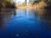
I've always loved when the ponds start freezing over. Nute's Pond on Bainbridge: Even the beach is completely frozen up in the shade. Looks like it snowed!
 1 point
 -
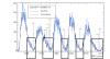
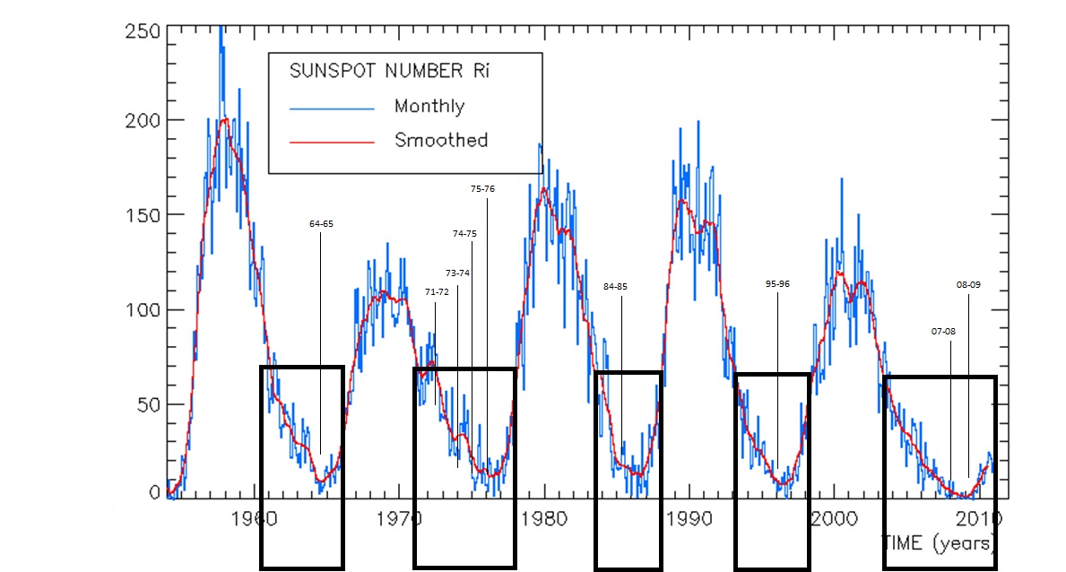
I had recently been looking at the correlation between snowfall during La Nina winters and the solar cycle. Sorry, but I only looked at sites in SW BC. Snowfall amounts nearly double in relation to average when a La Nina winter coincides with a period of decreasing or low solar activity. Not sure if anyone really knows about what may occur as we likely enter a period similar to the Dalton Minimum. Location Average Snowfall Average during years of Average during years of Decreasing or Low Solar Increasing or High Solar ShawniganLake 29.5" 52.3" (177%) 31.1" (105%) Abbotsford (YXX) 21.7" 46.5" (214%) 22.7" (105%) Vancouver (YVR) 15" 31.9" (213%) 17.7" (118%) Here are the individual La Nina years I used that occurred during low solar. *EDIT. 1985 (remarkable November), and 1996 (December Blizzard) just missed making the cut for a La Nina, but were cold ENSO years, I would guess the argument could be made to include them.
 1 point


.thumb.jpeg.e3014abf99ef08a9f9ac2c0cd31b485b.jpeg)


This leaderboard is set to Vancouver/GMT-07:00