
Leaderboard


Popular Content
Showing content with the highest reputation on 12/03/15 in all areas
-
Good lord.....3 points
-
Warmer means less money on heating bills3 points
-
I sure hope someday we experience a January 1950 type event...it would most definitely bring everyone together on this forum. Anyway it's currently fairly mild, dry, breezy, with a hint of sunshine. I have a plane full of rescue dogs landing at 5:30 at Paine Field in Everett..that should be interesting offload during the peak of the windstorm.2 points
-
Why does it matter? He usually just gives his forecast without much opinion. Your dislike for him is strange to me.2 points
-
HAHAHAHAHA! Check this out! https://fox12weather.wordpress.com/2015/12/03/ready-for-60-degrees-strong-wind-2-3pm-too/2 points
-
Going to be a mild next week. Some 50+ lows and river flooding would be fun.1 point
-
Seattle had a white Christmas that year I think.1 point
-
Except for all the ones that would lose power. Dec 2008 was a pretty cool time on here.1 point
-
mountains are getting tons of snow at the higher places and north. Also the east slopes and okanogan highlands.1 point
-
Indeed, we are situated in a fairly good region that should do well in the snow department. I think we will be tracking many major storms along with pacific waves/ripples in the jet when the "weaker" part of the cycle hits.1 point
-
What Geos posted above. Massive trough. And the stuff Tom posted. The potential is big to me. That's my point.1 point
-
18z GFS has plenty of chilly weather and western troughing.1 point
-
Taking with a grain of salt right now considering it's still in lala land. This time next week we should have a good idea if this will be a Snow producer.1 point
-
Interesting little guy around a week out on the 18z.1 point
-
You'll be fine. It may still be Jesse against the wrong rest of the world, but we'll welcome you with open arms when you're ready. It'll be like the end of Ghost, just without the pancreatic cancer later on.1 point
-
Just like with Mark, you are a little delusional with this partisan BS. Dynamic weather is fun to most weather enthusiasts. Fringe, I know...1 point
-
If you can think 60s in the summer suck then I can think 60s in the winter suck!1 point
-
We have those t.v. weather personnel types up here in Vancouver, sun and warmth worshippers however there are a couple that are not biased one is or had worked for Environment Canada. Seems the female casters are the worst cold ruins their tan lines.1 point
-
I have been waiting to post on this, but now I'm seeing the Euro show clear signs of rising heights directly over the Pole. Over the last few days, the Euro begin to show signs that a building area of HP to set up around the 8th and beyond. I'll show you on maps below what is going to happen over the next 5 days. Current conditions over the North Pole are split, one being a piece of the PV to the east of Greenland and a weak HP just north of Eurasia. In 4 days, the HP expands over the Pole and kicks out the PV farther to the east of Greenland to just east of Iceland. Meanwhile, NW NAMER begins to load up with arctic air and the evolution of the pattern is setting up. By Day 8, HP over the Pole is in full control and is becoming stronger. Day 10, it is strengthening even more. We'll see how this all evolves over the coming 10 days but it is certainly arranging the pattern in the mid-latitudes towards some fun and games.1 point
-
Gary over at weather2020 released his winter forecast. It's an interesting read. Says we're headed into a thirty stretch of stormy weather in the Plains/Lakes. Temps will be mild for most of the country, with the exception being the Southwest. Believes that the AO and NAO will stay neutral or positive for most of the winter. When it does dip is when our best chances for widespread snow will be. States we'll have one artic outbreak at best but none like we've experience over the last couple of years. If you don't subscribe to his site already I highly recommend it.1 point
-
It's too bad our best local met has gone so strongly toward the dark side. Cold, rain and even snow are written off as mere annoyances, but if it's gonna be warm or sunny, oh boy!! He should check to see if there are any pro-met positions available in San Diego. He would probably be pretty happy down there.1 point
-
+1 Jesse.1 point
-
The general pattern is still good. If a trough hangs around over the west a good part of December someone will see snow eventually, even if we never manage to tap into really cold air.1 point
-
Wow, That did not turn out right! Any way what I had posted was that on April 23/24 2005 that Flint had 8" of snow and that way back in 1923 Flint had 12" of snow on May 9th and that May snow fell during the day time. dont know what I did the first time1 point
-
There is a fair amount of snow forecast for the Sierra today; up to and over one foot in northern California. Wednesday: 79 / 55 Lo: 60 Revised: 571 point
-
12z GFS looks a little weaker and further NW with the low. Wouldn't make for as strong winds.1 point
-
The trough being depicted late next week on the ECMWF is nothing short of ridiculous. The main jet and 552 height line go well south of San Diego. the entire West is reasonably cold with an epic torch in the East.1 point
-
Guess what? The CPC now agrees that Western WA and parts of Oregon are no longer in drought now!1 point
-
This might actually be an appropriate time to obsess over the WV loop.1 point
-
And the ones who voted for November carry the day!1 point
-
Almost! I often do my analysis in the nude, or I'll display a blue tutu...1 point
-
So yeah, please send the big one our way first. We truly do deserve it over here.1 point
-
No Richie I've never pooped a Walgreens. Ouch!1 point
-
Not a "Walgreens". ...1 point
-
We need to send a bigger snow system to Nebraska before our next big one though! They need to catch up! @ Tom A high near Greenland or over Greenland and one over Alaska can act to destabilize the polar vortex. Start hooking that ridge over the top and its days are numbered - in its tropospheric form.1 point
-
I think it's going to be near the 20th maybe a little before, before we start seeing widespread wintry weather. I think there will still be some wild temperatures swings late in the month, but not as many far above normal days for temperatures. I think most of the central Midwest/Corn Belt regions on southward will continue with the wet pattern straight into January. I think certain teleconnections are sending the moisture further north than you would expect in a strong el Niño winter. With regards to snowfall; here at almost 16" so far, that tally wasn't reached until the blizzard on February 1st last year.1 point
-
Just saw Skilling's weather segment and ORD has had its Top 5 snowiest start to any Winter season...official total thus far is 12.4"...1 point
-
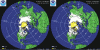
This is sobering. 0% icing on Hudson Bay this time last year. This year same time, 50%.
 1 point
 -
This x10.1 point
-
How do you know that it won't be as cold as shown?1 point
-
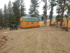
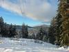
Here are a couple pics jim, winter pic was last year. thats off my deck.
 1 point


.thumb.jpeg.e3014abf99ef08a9f9ac2c0cd31b485b.jpeg)


This leaderboard is set to Vancouver/GMT-07:00