
Leaderboard


Popular Content
Showing content with the highest reputation on 12/02/16 in all areas
-
Hey thanks. She is doing much better. Model riding and discussing weather with you all is very helpful distraction.5 points
-
3rd and 15 with jay cutler as qb5 points
-
I guess everyone was put off by my perceived "Negative Nancy" persona yesterday, but I wasn't trying to drag people down...I guess I should have said something similar to tonight versus blurbs that come across as simple naysaying. Maybe miniscule improvement on the 00z tonight vs 24h ago...or maybe I'm just choosing to see it a bit more optimistically.4 points
-
Arctic Kush with a dab of Drunk Uncle's fairy dust. Snowing here now but expecting marginal accumulations due to temps at 33 F. Should get purdy cold next week. Snow chances late Monday and Thursday should be enjoyable as high temps will be in the teens and 20's. Hoping to get 6" at least b/t the two storms and 1-2' in the mountains.4 points
-
Hope DJ's mom is still doing ok...he is usually awake by the Euro.4 points
-
Destroyed? Really? Chris is a good guy and is well respected on here. He can take some constructive criticism for a forecast. Just about every response to his post was respectful and based in meteorological/model analysis. You make it sound like people just called him a moron and said we'd get a foot of snow because their psychic said so.4 points
-
The post heard around the world. Kind of a shame that an employed meteorologist in Oregon can't take a stab at a forecast for PDX in the medium range without getting destroyed for his "pessimism"... There are seriously nearly two pages of posts ripping that post to shreds like a mob of rabid, snow starved villagers with torches. "Hang that bloody heretic!" I'd take Chris' analysis over the "I have a feeling the models are going to trend snowier"/"I have a sneaking suspicion the dry pocket is going to moisten"/"Even in a borderline scenario, my gut is telling me that it's going to start and stay as snow despite the models" analyses. I definitely want my doctor to stop chemo because he has a "gut feeling" the cancer will stop spreading. I don't necessarily agree with Chris' forecast, but it's kind of outrageous that a met can't post a preliminary forecast without being told that they are "not accomplishing anything" -- I think posting a forecast with an analysis to back it up is accomplishing more than the "my palm is itchy so it's gonna snow!!!" posts, which set people up for heartbreak.4 points
-
Is the King Euro a new model I didn't know about?3 points
-
Dude, should we call someone for you or what?3 points
-
I think the models are getting to him!3 points
-
What the f*ck are you smoking?3 points
-
I have a gut feeling that this is only the beginning. We have a very decent shot at having one of the coldest winters in 40 years. I'm almost certain that this will be the start of a new regime. History tells us that this is going to be an epic winter.3 points
-
Cliff mass is going all out for a good amoint of snow. I think he is hitting the bottle again.3 points
-
Nice to see the overall cooling the longer range. No above normal temps.2 points
-
00z ECMWF Begins in.... 2 minutes I hope the Kona low behaves for KING EURO and the GOA/Alaskan block. Hold the Kona off to the west/southwest. Please. C'mon, I said please real nicely. Feel free to play along(You may need to refresh pages) Northwest view - http://www.tropicaltidbits.com/analysis/models/?model=ecmwf®ion=nwus&pkg=mslp_pcpn_frzn&runtime=2016112912&fh=0&xpos=0&ypos=197 North American view - http://www.tropicaltidbits.com/analysis/models/?model=ecmwf®ion=namer&pkg=mslp_pcpn_frzn&runtime=2016112912&fh=0&xpos=0&ypos=197 North Pacific view - http://www.tropicaltidbits.com/analysis/models/?model=ecmwf®ion=npac&pkg=mslp_pcpn_frzn&runtime=2016112912&fh=0&xpos=0&ypos=197 Alaska view - http://www.tropicaltidbits.com/analysis/models/?model=ecmwf®ion=ak&pkg=T850&runtime=2016112912&fh=02 points
-
WOW! Was I ever right about this. A MASSIVE cold pool develops and persists over the Columbia Basin. There will be very cold air to tap into for PDX. Look at Moses Lake. Note the 925mb temps and then look how at the deep cold. http://wxweb.meteostar.com/sample/sample.shtml?run=2016120300&text=KMWH2 points
-
My thoughts for Monday haven't really changed...still thinking a mix or wet non-sticking snow for most below 500-700 feet in Portland with sticking snow up closer to 1000 feet, potentially 1-2".2 points
-
They are afraid that it will bust. Safer to be pessimistic in a situation like this.2 points
-
Acually it looks pretty dang good to me next week. Could end up being the best week of winter for alot of us in the past couple years.2 points
-
It just started lol.2 points
-
925mb temps dropped a little down to -2C for PDX area on Monday morning. Widespread 2-4" snowfall amounts for the metro area is the result.2 points
-
Not much snow on the ground. Dry cold is B-O-R-I-N-G.2 points
-
2 points
-
For those keeping score the 12z ECMWF operational and 18z GFS ensemble mean both show 850s dropping to -9 for Seattle. The number I said we were likely going to see a couple of days ago. Not bad for a wish caster like me. I also mentioned later model runs would probably remove the snow shadow from the Central Puget Sound. Happened on the 12z GFS, 18z GFS and 12z ECMWF. Some user who shall remain nameless really pissed me off this morning so I will gloat if this all goes according to plan.2 points
-
Yeah the Euro ensembles looked great in the mid-long range. Gives me hope that the pattern won't go back to total poo after our brush with cold next week.2 points
-
FWIW - Quite a few arctic type (-12C to -18C 850s) cold members on the 12z EPS Ensemble beginning around the 13th-14th.2 points
-
I've been praying for him and his mother all morning. I've really missed his posts today and hope everyone is okay.2 points
-
This wasn't needed.2 points
-
I really wouldn't want to watch a weather nerd porno. Ugh.2 points
-
Was it over when the German's bombed Pearl Harbor? (Animal House reference, John Belushi)2 points
-
I feel like these long long range models have been all over the place lately.2 points
-
He is f ucking annoying alright. And I thought Tim was bad.2 points
-
The over-reaction on here has been amazing the past couple of days. In basic it will still get cold and there will probably be lowland snow.2 points
-
In case anyone cares, the 06z NAM is a bit faster with the cold at least at hour 60.2 points
-
Has to do with the slightly worse resolution of the ensembles vs the operational...in the nearer term the ensemble plume correlates better so it looks like the operational is an outlier when in fact the operational at a higher resolution has a better handle on terrain. At 850 mb there's still plenty of terrain influence.1 point
-
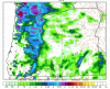
It almost always overdoes snow, but rarely does it completely miss the mark. Showing this widespread of snow is a good sign.1 point
-
It just seems so unlikely in this pattern.1 point
-
Nice model trends today. Much better scenario for snow in the Seattle area Monday night than yesterday's runs.1 point
-
Also juicier with precip Monday/Monday night. Pretty clear CZ signature.1 point
-
He wears himself out from following all the models so closely for days on end. Weenie fatigue, can happen to the best of us.1 point
-
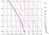
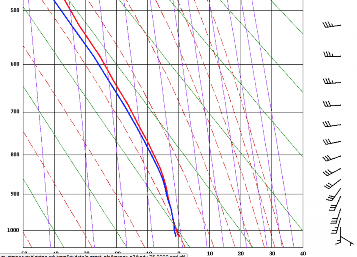
12z WRF 4km sounding sure looks like a snow profile to me on Monday morning at PDX. Not sure what all the fuss is about.
 1 point
 -
Then there is this....1 point
-
They're only all over the place when they're bad. On the good days they're really onto something.1 point
-
Agreed. The GFS is a complete whiff from what I can see. Hardly any snow for anyone. That northern piece literally destroys what would be a world of potential for this storm.1 point
-
Good thing we don't really have to start paying attention to the details of that event for a couple of days.1 point
-
I'd agree with you in almost every case but the large HP centered over CO disagrees with both of us.1 point


.thumb.jpeg.e3014abf99ef08a9f9ac2c0cd31b485b.jpeg)


This leaderboard is set to Vancouver/GMT-07:00