
Leaderboard


Popular Content
Showing content with the highest reputation on 11/19/20 in Posts
-
Hi, new member here from Brookings. How is everybody?7 points
-
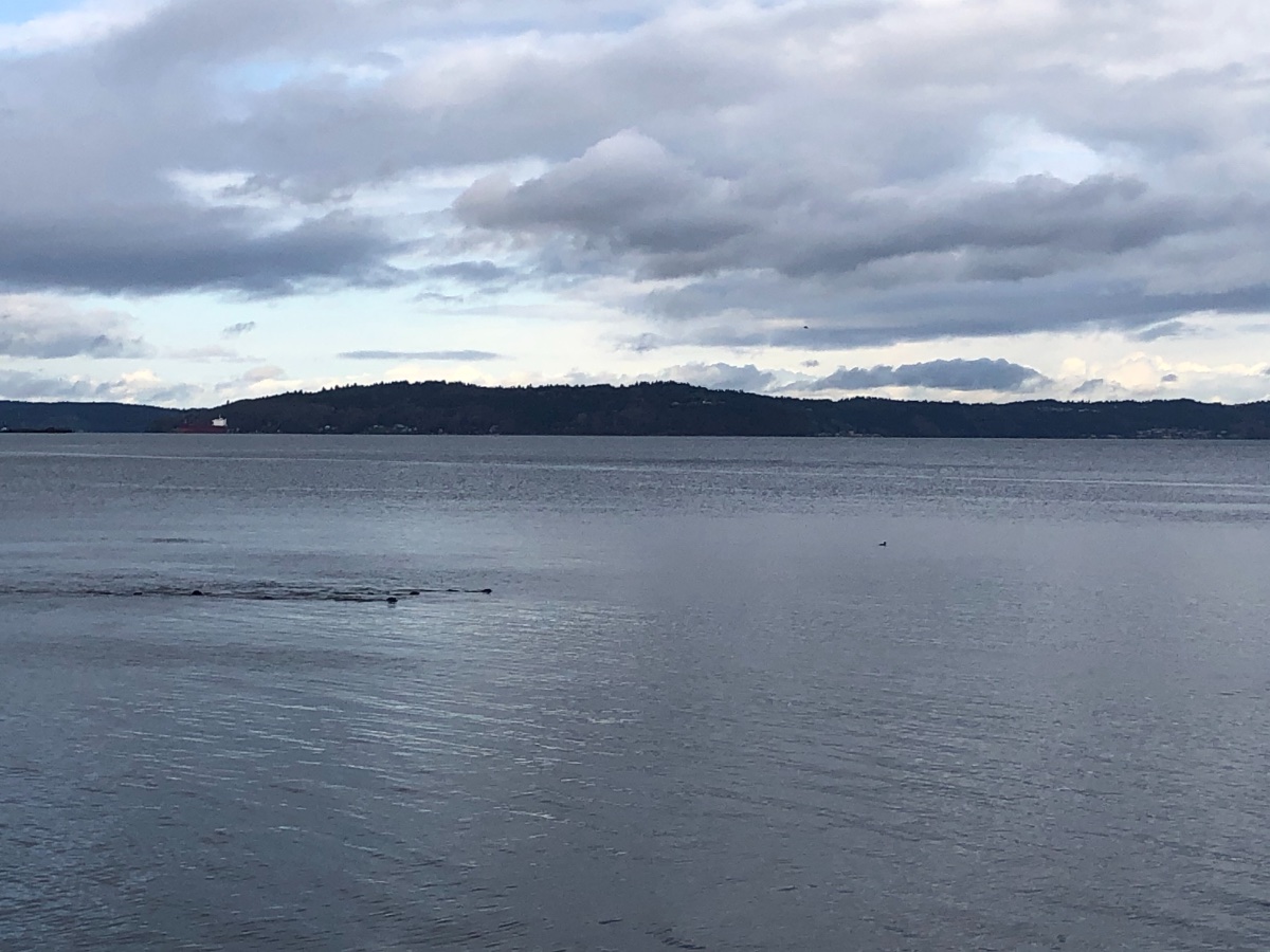
Pretty morning...
 7 points
 -
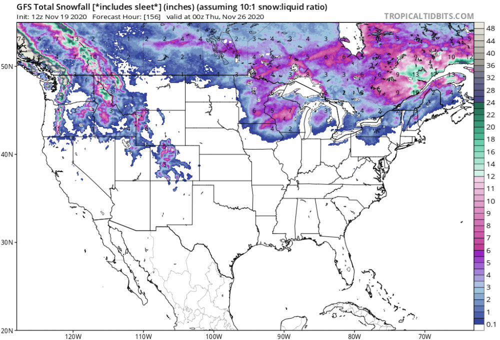
GFS now seems on board with a nice little mountain snow producer the middle of next week.6 points
-
How hott next summer ends up is literally the last thing I want to worry about right now.5 points
-
Our good window for big snow events really seems to be about January 1-March 25th. It seems like once we get into February/March it doesn't take much for snow here, whereas earlier in the winter, especially before say January 10th, it takes a really significant trough/airmass to deliver meaningful snowfall. In a decade up here we have had about 5 4"+ snow events before January 10th. Whereas we have had in the range of 15-20 such events later on.5 points
-
Icy out there this morning. With a mix of showers and clear breaks overnight, a lot of the moisture froze up pretty good. 32.6F for the low.5 points
-
As I've mentioned before on here. If you are buying a station mainly for wind I recommend a wired station. That way you get instantaneous updates on the windspeed. With wireless it usually samples every two or three seconds. Watching the gusts is more fun with the constant update.5 points
-
Hahaha that poor guy was confused as hell. I think he left after he kept trying to get the forum stoked that it was gonna snow in Arizona but instead everyone was just pissed. The version of hazing here is if you're a new poster everyone insists you're a former troll. You gotta keep posting through it.4 points
-
After what I assume is 3 months of planning and whiteboarding names and a full backstory, CulverJosh attempts to catfish the forum and gets caught in less than 10 minutes. This forum is more suspicious of newcomers than the family in Dogtooth4 points
-
Any other girls here?4 points
-
Well since this winter season is an apparent write off with bad Hadley cells and terrible WHAM numbers...What should we talk about now?4 points
-
That’s about what I’ve been expecting in the lowlands: close to climo averages for snow. The mountains should do really well, though. Can’t understand all the upset over a snow-free November. That’s quite often the case. Dec, Jan, and Feb historically are when most lowland snow events happen.4 points
-
I rarely post on long range- and I'am cold/snow biased- so take that into account . I will admit it. Without posting maps (as Iam sure many look at and what Beltrami posted in the other thread) things are not looking good (if you like winter) for the next several weeks at least-- maybe imo, through most of DEC, if not into JAN. Systems will roll through but likely without enough cold air to produce winter precip outside of maybe the far North. IMO- the longevity of the tropical season (not totally shut down btw) with the LA nina in place is more akin to back loaded winters (if you wanna call it that- I don't- as I see winter over (starting?) by Jan 15th or so with rapidly increasing sun angle and daylight- especially here in IA) -- I see an overall winter - in the best like 98-99. That's a stretch at this juncture... For sure a DEC to remember for (cold and snow) is again not going to happen and WHAT you want to build on cold and snow. It may get winter like in FEB/MARCH like it has the past several years (out of many) , but this winter is looking blah at BEST-- and FTR- I've done long range forecasting in the past for ski resorts (Lutsen Mtns in MN in the early 2010's) .. I just don't see "real" winter this season until sometime after Jan 15th for many reading this S of 45N latitude. I hope i'am wrong of course but the trends and setups of teleconnections don't look favorable until maybe late winter. Carry on.4 points
-
The drier weather should allow me to make preparations for when January 1950 inevitably hits.3 points
-
Re-strengthening and a major trade burst is ongoing.
 3 points
 -
30 hours ago it was a string of 20's and this pm a string of 60's. Quite the ride we're taking. 65F for the high so we blasted past the 59F forecast. Finished my autumn yard chores and got started on holiday lights. About 7-10 days earlier than usual but I cannot remember stringing 'em up in shirt sleeves before.3 points
-
Here in T-town we have only had 0.73" of precip since Oct 1 which is only about 21% of normal, though we do have rain chances during the next week. Dry and warm has been the rule with Nov temp anomaly running at +4.3F for the month. I sure hope Dec-Feb is not like this...lol3 points
-
A thin band of moderate-heavy rain is about to pass. Icing is a concern with temps being around freezing.3 points
-
Suns back out again. Nice mix of rain, ice pellets and sunshine today up to 0.50”.

 3 points
 -
We are pretty sheltered here and tend to decouple really quickly on clear nights. We get a lot of winter nights that see temperatures bounce around freezing when we are in a showery airmass. End result is a lot of black ice.3 points
-
I actually have a sense of peace about this winter. That's a real rarity for me.3 points
-
Looks like the models are converging upon the idea of the next week drying out a little, but staying relatively cool with clipper like systems brushing us every couple days. Should continue to add to the mountain snowpack and give us some cooler anomalies down here at the surface.3 points
-
The further south you go the bigger the blast was in 2010. It's not every year we get over a foot of snow and below zero temperatures around Thanksgiving in K-Falls. That had to have been a once in a generation type November blast. I missed the whole thing, but it did continue snowing more inches into early December. From 11/20 > 12/03 we had like 2/3rd's of my seasonal average in those two weeks. Dried out a bit towards mid December and it got snowy again 2nd half of the month. Had a nice little blizzard event day before my birthday on 12/29/2010. January was bone dry, but February brought more goods.3 points
-
Keepin hope alive
 3 points
 -
I'm not sure what the models are catching onto, but I'm seeing a good indication on a wide variety of models for a cold pattern the final week of December. The 6z CFS run showed a monthly average 8C below normal (surface temps) for the month of January in Seattle. Would love to see that verify.3 points
-
Today looks to be another mild and windy day. Several items come to mind for this November. 1. How warm it has been. 2. How windy it has been. and 3. how much sunshine we have had. Today forecast is for highs in the lower 60's while todays record high is 74 set in 1930 and it has reached 70 or better 3 times. But if it reaches into the lower 60's this would only be the 14th time it has reached 60 or better on November 19th in Grand Rapids recorded history.'3 points
-
Grizz, love reading your input and I agree with you, that we will prob have to deal with marginal events around our region as I don't see a "true" arctic source of air to tap over the next couple weeks. That's not to say someone may get lucky and see some snow into early December. I will say, however, with growing confidence as more data comes in, that by Dec 5th onward, the North American 500mb pattern will veer away from the trough in the west and begin to shift towards better blocking across western NAMER, but esp eastern Canada and Greenland. It'll be a slow process but I believe it's going to happen. IMHO, this will be a different December in terms of blocking and a more seasonal month compared to the blow torch's we have seen in recent years. I'm really getting a good feeling about next month producing a favorable pattern for our Sub to see winter storms before the Christmas holidays. Based on my research and previous posts regarding the 10/30/50mb maps I've shown before, I'm going to ride the idea we will see the west coast ridge begin to pop post Dec 5th onward. In fact, after reviewing the latest JMA weeklies, I'm convinced it will happen even more because it is agreeing with my thoughts...LOL...
 3 points
 -
PHX did it again and set a new record high yesterday of 89F. Thankfully, that'll be the last of the record heat for this year, at least no more 90's...now comes some real delightful weather with temps in the 80's and 70's all of next week. Prime time late Autumn weather in the valley of the sun. Regarding the storm system for this weekend, it continues to trend S and has a TX Panhandle Hook "look" to it, right?

 3 points
 -
The long range only goes out to at most 15 days. Except the ECMWF weeklies, which goes out 46 days. And it shows blocking and potential cold in mid December. Too early to rely on models. FWIW the CFS shows a lot of blocking all winter. Guessing Eastern WA and Oregon get above average snow. I am actually way above average snow for this time of year.3 points
-
WAIT.... WAIT! Okay, I know it's "fake cold", but the Canadian ensembles really wants to develop a substantial Columbia Basin cold pool. This fake cold could become quite chilly for PDX/Gorge. I assume east winds would become a player too. Is it sad or? that I'm excited about this. I need therapy. Help me. Okay. C'MON!!!!2 points
-
Managed to get to 6.02” on the month now...0.61” on the day. Looking like things may start to get drier...oh well was a good run of consistent wet weather here. 15 out of the last 19 days have had rain...currently riding a 8 day rainfall streak as well.2 points
-
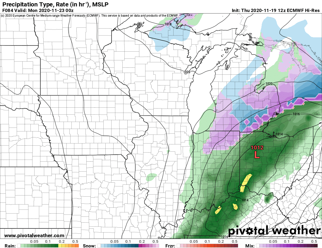
My day off work so been busy with said chores and errands, but now enjoying a quiet evening and a great one at that as I find myself in snow tracking mode for the first (legit) time this season. While some globals have shoved the main precip swath south of the Mitt completely, the Euro, Ukie, and now in range NAM are reflecting a curl northward as shown on Tom's map this morning which brings decent qpf into SMI. These same models also turn just cold enough to indicate some if not all the moisture falling as snow. Not a huge deal by any means, but 2-5" amounts seem in play attm. Waiting for 0z runs ofc, but my pm AFD is actually saying that accumulations are possible. NAM 12k has a nice looking development and is on the colder side with virtually all snow.
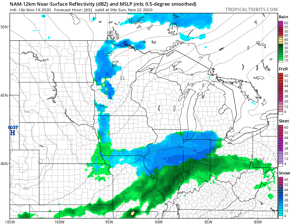
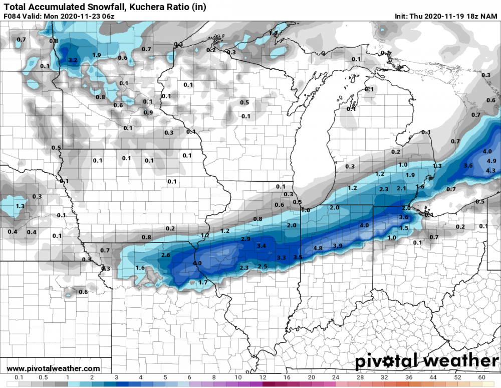

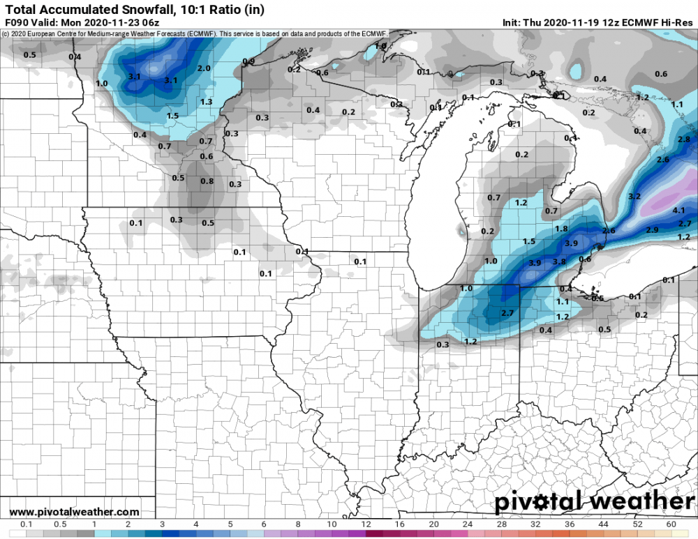 2 points
 -
Hopefully if we do get a period of ridging in late Nov / early Dec it will set up right to give us a nice foggy inversion. I always like seeing one of those during the cold season.2 points
-
I don't do conference calls. No need when you work as a fry cook at Mickey D's.2 points
-
Compressional heating and conference calls are what Brookings is all about.2 points
-
+EAMT/AAM spike coming up late November into the start of December. In this case, we get a temporary +PNA/GOA trough response, kinda reminiscent of a strong niño. Transitions to +EPO/+NPO/-PNA and by the middle of December. In both cases, the vast majority of the country torches (possibly the entire lower-48), and there’s no arctic air in sight yet. Not even modified arctic air.2 points
-
Hopefully the solar grand minimum will begin to cool things off over the next few years so we can put some of the world is on fire because of mankind narrative to bed. I'm not sure if you've seen it yet, but the NOAA projections for the next solar cycle show a decade of nearly no activity. I couldn't believe it when I saw the source data. That would be something to see.2 points
-
I think the PNA projections on the Euro weeklies sum it up best. The mean shows a steady fall through much of December. If the control has its way things might get going faster.
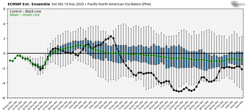 2 points
 -
That was a nice day here. 32/23 so pretty cold, but sunny until evening. Started snowing around 10pm and we ended up with nearly 8” total by the time it wound down the next day.2 points
-
Had 1.27" yesterday and are now above normal so far on the month. Excellent!!2 points
-
Thanks for posting this Clinton... Looks like a decent hit! I remember Ukie scoring big a couple of times in recent Winters. Something to keep an eye on for our regions this weekend. Do I dare get my snowblower ready during Thanksgiving week? I would not mind, as this would be an acceptable timing in my books. As long as its not early to mid November!2 points
-
I would love another Christmas Eve/Day snow. The one we had a couple years ago was magical.2 points
-
Thanks bud, I didn't even think/remember to peek at the Ukie. Perhaps I spoke a bit soon and I'd gladly be wrong on that, lol.2 points
-
The UKMET looks like the EC with 2 snows for ya in the next 7 days. Round 1 And the total from the 2 storms.2 points
-
All I'm going to say is we have plenty of extra aces in the deck this winter. A better chance of something good than an average season.2 points
-
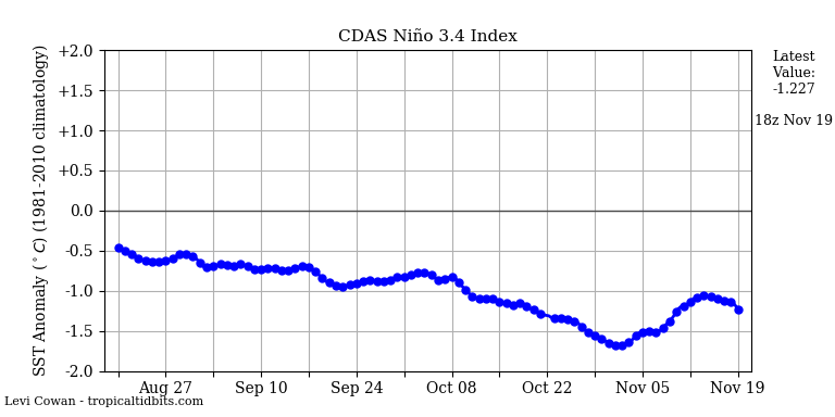
8C below normal for a monthly average would be one of the coldest Januaries on record. That would mean Arctic air much of the month. Probably at least 8 to 10 highs below freezing. A good percentage of the recent CFS runs have indicated a very cold January. The CANSIPS has looked good for that month as well. The ECMWF looks more impressive for Feb, but still has a chilly look for Jan.2 points
-
This! Was thinking the same thing as the brightness of it shone in my bedroom windows and woke me up yet again. I can't remember so many sunny days in every season for this area. Feels like Florida tbh.2 points
-
6z GFS for the tue-wed system
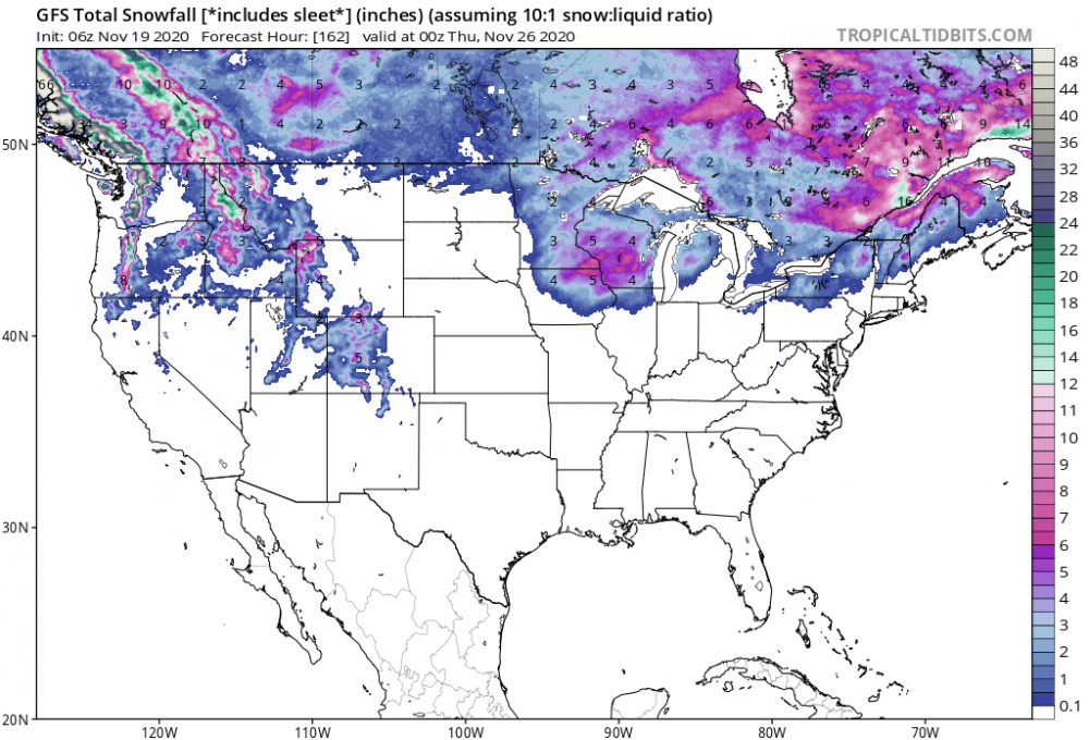 2 points
 -
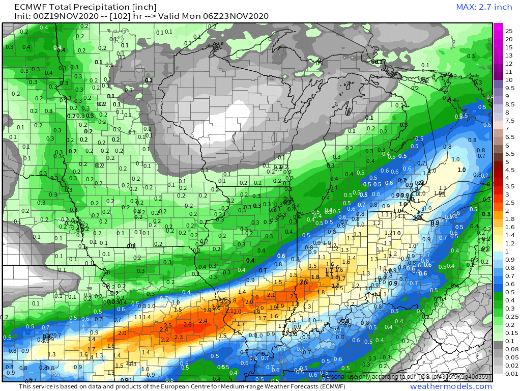
Based off what I'm seeing, it appears to me that there will be 2 or 3 storm systems to track throughout Thanksgiving week. These systems will primarily target the eastern and southern Sub while those out west are stuck in a dry pattern. The flip towards a +PNA pattern will keep the storms from cutting NW. Temps for the most part look marginal for any wintry precip, but the moisture is what a lot of members need. It's still early in the cold season to talk about snow that will stick around for more than a few days. Take what mother nature gives ya. After this weekends system, the Black Wednesday storm looks to effect almost the same regions that will benefit from this weekends storm. Following that, the EPS ensembles are picking up a storm forming out of the TX Panhandle region and tracking into the OHV. This particular storm may lay down some snowfall. With that being said, look at that AN precip stripe across the S MW into the Lower Lakes region. Thinking about Snow??? The EPS is targeting the GL's region...primarily late month into early December...

 2 points
 -
Thinking I am going to wait until morning to walk 500' out into a dark field in the rain to check the manual gauge...There are wild beasts afoot.2 points


This leaderboard is set to Vancouver/GMT-07:00