
Leaderboard


Popular Content
Showing content with the highest reputation on 02/16/22 in all areas
-
8 points
-
Finally FINALLY i have the help i need at my Business! Been away from the forum because of the 16 hr days 6 and 7 days a week to keep up. At 49 years old i can't continue that so the right guy finally came around so now we have 3 men in the shop.8 points
-
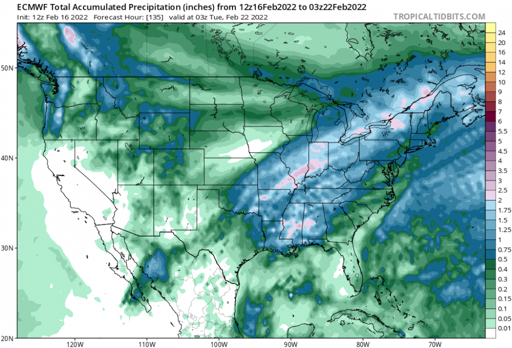
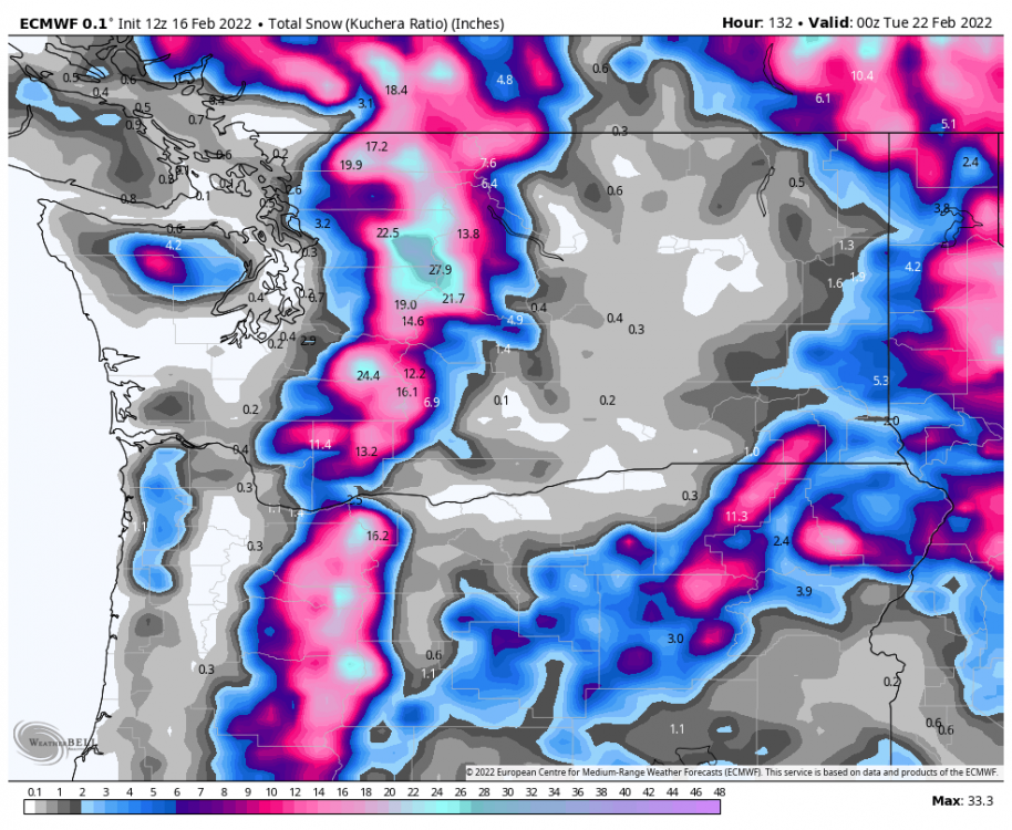
00z ECMWF 10 Day Rainfall, Snowfall totals6 points
-
GEFS even colder Gorge, Columbia Basin! This is looking very impressive.\6 points
-
About as solid agreement as you could expect at this range on the EPS
 6 points
 -
The last third of February is our new troughiest time of the year. 2017, 2018, and 2019 all had extensive troughs in the same window.6 points
-
6 points
-
Part of it is me because I'm very picky who works for me. We have a very good rep that has taken 30 years to create so you have to be careful. Hard to believe it's so hard to find good help and i pay good. My top guy makes 38 per hr and the new guy is 30. That is not crap pay. Full benny's and 1 week pd vacation along with all pd holiday's starting on first day.6 points
-
This is giving me a heart attack! This is more stressful than a chiefs game lol5 points
-
21z SREF Mean staying juiced. Models have really been increasing totals over east central Kansas.5 points
-
Weather forum activated! Meanwhile…nice day and currently 49*5 points
-
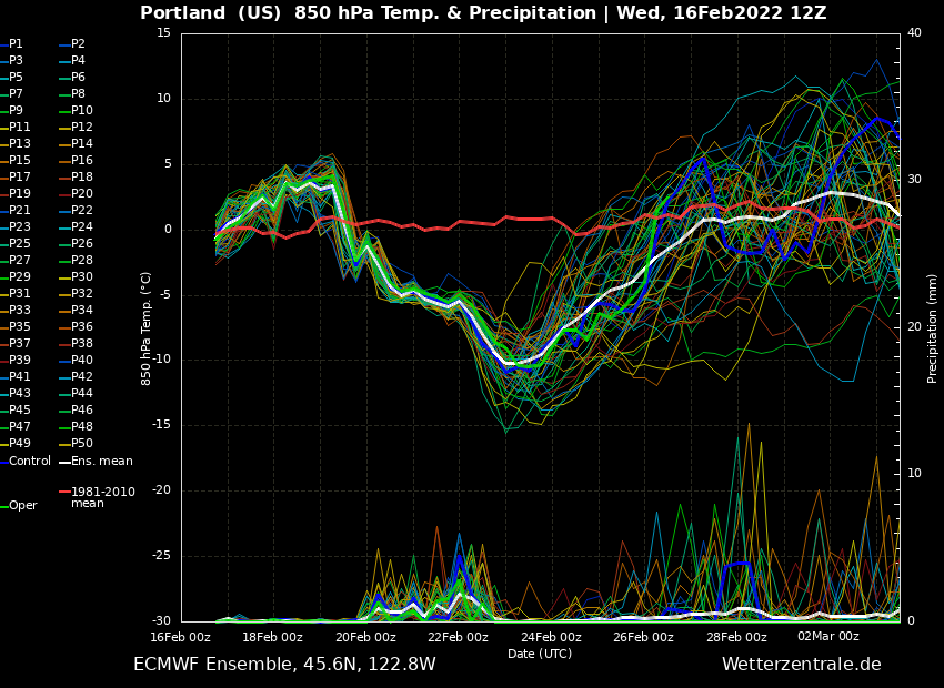
GFS Ensembles trending colder Portland: 12z -7.8c, 18z -9c Seattle: 12z -7.7c, 18z -9.4c Moses Lake: 12z -12.4c, 18z -14.7c5 points
-
Literally can only laugh at us in Lincoln. Wash, rinse, repeat5 points
-
Could be some old school two blanket nights coming up, as Jim Bosley would say.5 points
-
Euro upped my QPF from about .14 (00z) to about .41 on this run. A modest amount but certainly better than before.5 points
-
Winter Storm Warning issued: ...WINTER STORM WARNING IN EFFECT FROM MIDNIGHT TONIGHT TO 6 PM CST THURSDAY... * WHAT...Heavy mixed precipitation expected. Total snow accumulations of 4 to 6 inches and ice accumulations of up to one tenth of an inch. Winds gusting as high as 35 mph. * WHERE...Portions of east central and northeast Kansas and central, north central, northwest and west central Missouri. * WHEN...From midnight tonight to 6 PM CST Thursday. * IMPACTS...Travel could be very difficult. Patchy blowing snow could significantly reduce visibility. The hazardous conditions could impact the morning or evening commute.5 points
-
Send prayers.
 5 points
 -
Awesome call on the Multnomah County Sheriff scanner. Adult male dancing naked in the Multnomah Falls parking lot. 6z GFS in 41 minutes5 points
-
850s -19c Yakima close to what I hoped to see.4 points
-
So... haven't paid much attention to the models for a couple weeks and I come back to some genuine before-240 hour eyecandy. Fun stuff if February delivers again4 points
-
Looks like another significant February cold snap in the works. Totally unreal. The model progression the past couple of days has been the definition of a sneaker cold spell. Something that started out looking rather pedestrian has trended to a low end Arctic outbreak.4 points
-
Kind of close to a late season bitter blast if the PV phases better with the arctic trough. Ya never know! C'MON!!!! 00z ECMWF in 6 hours 57 minutes4 points
-
Decent chance it ends up cooler than average in a lot of places, too.4 points
-
I am NEVER looking at the GFS again. It had my location in the main band for 3 or 4 days. I was supposed to be getting at least 8 inches according to it. My forecast in St Joe is around 1 inch... People, that is BAD. Absolutely unacceptable for a major model to do that poorly 72-48 hours from a storm. I am done4 points
-
One of my pet peeves in the weather is when the local media says " only in your state" does such temp extremes happen .--- Only in IA does the temp change 50F in one day. Only in Texas and on and on. It happens in 49 states - Hawaii maybe the exception. But the media likes to make you feel that your location/state is special -- It's NOT. Some more locations more than others--- ND to SC, I get it, but drastic temp changes are very common. ND ( North Dakota ) btw - for those that don't know has a higher max temp 121F-- than Texas of 120F. That's insane. Dust bowl. Go figure. And both North Dakota's max- 121F and -60F happened within 5 months of each other. Climate was changing hard core in 1936!!4 points
-
My wife just started a new job supporting cancer treatment/research and didn't find out it was remote until they extended the offer to her. They wanted to weed out applicants who would be applying just because it was a remote work scenario. She got a healthy bump in pay, which was pretty crazy because she is still working for the same medical organization, and her old wage fell within the pay range of the new job. We are not complaining one bit!! Meanwhile, they are having a heck of a time finding her replacement at the Hospice care center she was working at. So, my wife and I are working under the same roof again...our house. The last time we worked under the same roof was at a pizza joint in Oregon 27-28 years ago where we met and started dating.4 points
-
It holds the upper level storm together and doesn't shear it out. Gary mentioned this in his blog this morning, this even shows some convection SE side of KC.4 points
-
Lol se Nebraska and western Iowa.
 4 points
 -
The Euro shows a low of 15F here next Wednesday??? And close to subfreezing highs on either side of that? That would be pretty remarkable and would be comparable to February 2011 in terms of temperatures.4 points
-
LOT mentions heavy snow in the early morning hours and RAP clearly shows this as well so maybe the RAP is onto something. Rain transitioning to a brief wintry mix and eventually all snow tonight and Thursday morning. Developing potential INVOF the Chicago-area sites for a brief burst of heavier snow roughly 9-13z.
 4 points
 -
12Z ECMWF shows snow for Randy on Sunday and Monday... and for me and Andrew as well.
 4 points
 -
and the all time low of -23F is not where you would think it would be,, like Dalhart or some place like that in the way North. (Dalhart btw gets brutal in the winter for TX's standards, near -10F every winter -- most can't say that this forum). It's here at latitude 32N- crazy low latitude for -23F outside serious elevation which it is not-
 4 points
 -
12z CMC 15z RAP is north and a good hit for Tom4 points
-
Hi, It's coming.4 points
-
It struggles in the the 2-5 day range for sure but it's been good (not perfect) in the 5 to 10 day and inside 24 hrs. I had hoped for better with the upgrade in the mid-range.4 points
-
3z SREF Mean @indianajohn @jaster220 @Niko4 points
-
EAX snowfall prediction Discussion: Temperatures this morning are about 10 degrees above the normal high for today`s date, with temperatures primarily in the mid 50s. Gusty southerly winds continue with gusts as high as 40 mph thanks to a strong low level jet that developed overnight. A Wind Advisory remains in effect until noon today, at which point winds should come down a bit (but still remain breezy through the afternoon). Water vapor imagery clearly shows the closed 500 mb low over far southern California as of 4 AM. A trough moving across Canada and the Upper Midwest will send a cold front into NW MO by later this morning. This will create a substantial gradient for high temps today, with highs in the mid 40s near the MO/IA/NE tri state border behind the cold front with highs as warm as the mid to upper 60s across the KC metro and points south and east well into the warm sector. Ascent ahead of the approaching trough will lead to showers developing by this afternoon with even some thunderstorms possible by late afternoon/early evening as we get up to about 500 J/kg of SB CAPE. As the surface low associated with the trough across the Rockies moves west to east across the Texas Panhandle later tonight, the cold front across northwestern MO will get pulled through the region, allowing for cold air to pour in from northwest to southeast. Surface temperatures should cool to below freezing by late evening (likely around midnight ish in KC). However, a warm nose aloft will remain in place, leading to freezing rain initially and then sleet. Some instability looks to still be in place during the sleet phase of the event, so would not be surprised if we have some thundersleet. Ice accretion and sleet accumulations will lead to slick roadways in the overnight period. Changeover to all snow will occur from northwest to southeast through the morning hours of Thursday as thermal profiles become entirely sub freezing as the surface low makes its way across NE Oklahoma and then along the MO/AR border. The period of heaviest snow looks to be between roughly 7 AM and 2 PM on Thursday. During this time northerly wind gusts up to 35 mph will be possible, significantly reducing visibilities and making travel extremely hazardous. Snow should taper off by mid to late Thursday afternoon. While there remains some discrepancies among the models, there is better consensus this morning and we are getting a better idea for where the greatest snowfall totals may be, which as of now appears to be roughly along an axis from the southwestern side of the KC metro (Johnson County KS) to the northeast toward Moberly where 6" to 8" of snow are currently forecast. To the immediate north and south of this axis, 3" to 6" are forecast. Less than 3" are expected across northwestern and far northern MO. A Winter Storm Watch remains in effect from midnight tonight to 6 pm Thursday, although an upgrade to a warning is likely by this afternoon at least for portions of the current watch area.4 points
-
I lived in Everett then and that was such a great period...one of the most memorable convergence zone snows because it dumped nearly a foot in Everett in mid April. Weekend before it had been near 703 points
-
Icon is rock solid.
 3 points
 -
I remember that March storm well. Mid 20s with moderate snow the night of the 19th. 32/26 on March 20, 2002 with almost 10” of snow on the ground.3 points
-
Yes...he did mentioned that......Good job Tom!3 points
-
Also unless this ends up being a major model collapse it’s looking pretty likely the February streak will live on this year. Six years in a row with at least some action3 points
-
Euro is pretty respectable for this late in the season. Getting one decent cold shot would really help elevate the status of this winter. I’m sure some people on the forum will even get a little snow.3 points
-
Well, I think it's a little of both and depends on the position. Bookkeeper is a nice office job with a desirable schedule that can be flexed to a hybrid office/work from home. Some other positions are much tougher to hire for, and we have applicants, but they are extremely picky, as in have very specific schedule demands. Workers have all the leverage right now in this market, because there are more available positions than people looking to fill them, I think the pandemic changed the dynamics in so many different ways, there is no easy answer to the situation. It's not all wages, a lot of it is what kind of flexibility does the job offer, can it be done from home, is it in health care. We already had a shortage of employees in healthcare, and the pandemic has compounded that, even though wages have risen dramatically in the health care field, so many are burned out or it just isn't worth the stress anymore.3 points
-
Congrats buddy! I've seen hard/quick-hitting 5" events be much more impactful than dbl-digits that took 30+ hours to fall. Hoping for a brief but dynamic hit here.3 points
-
12z CMC is coming in wetter. Doubled my QPF from .30 to .60 which is the most it's shown for me.3 points
-
As modeled it wouldn’t be a big whoop for most. Mossman will probably get a foot of snow somehow.3 points
-
I would prefer for it to warm up the second week of March to achieve a good growing season. Hope we get some widespread moisture between now and then esp in the dry areas. Severe weather season will be wild down my way imo.3 points
.thumb.jpeg.e3014abf99ef08a9f9ac2c0cd31b485b.jpeg)


This leaderboard is set to Vancouver/GMT-07:00