
Leaderboard


Popular Content
Showing content with the highest reputation on 08/12/22 in all areas
-
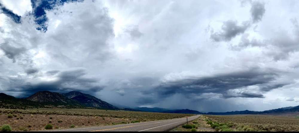
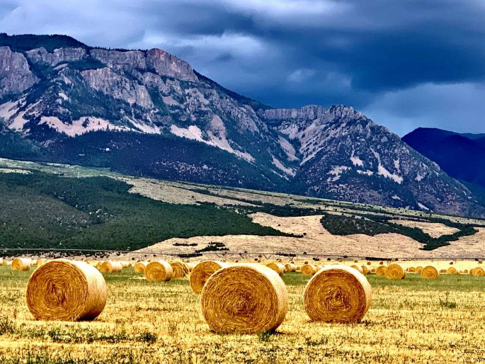
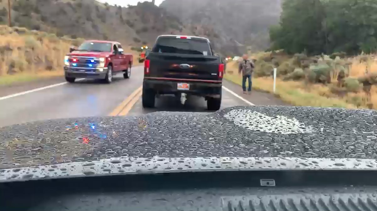
Storms hung with me most the day as I traveled 89 northbound. Just missed having to cross through and area of road that was flash flooding. While I was shooting the hay bails a cop went wizzing past me, I knew something was up. Glad they didn’t shut it down. Would of been a long detour. Had to sit around 30 minutes while they got the debris off road. Cool moment for me though

 11 points
 -
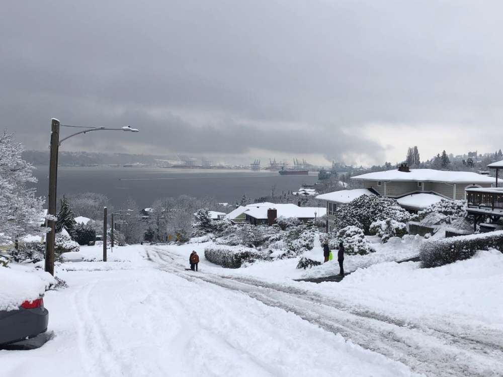
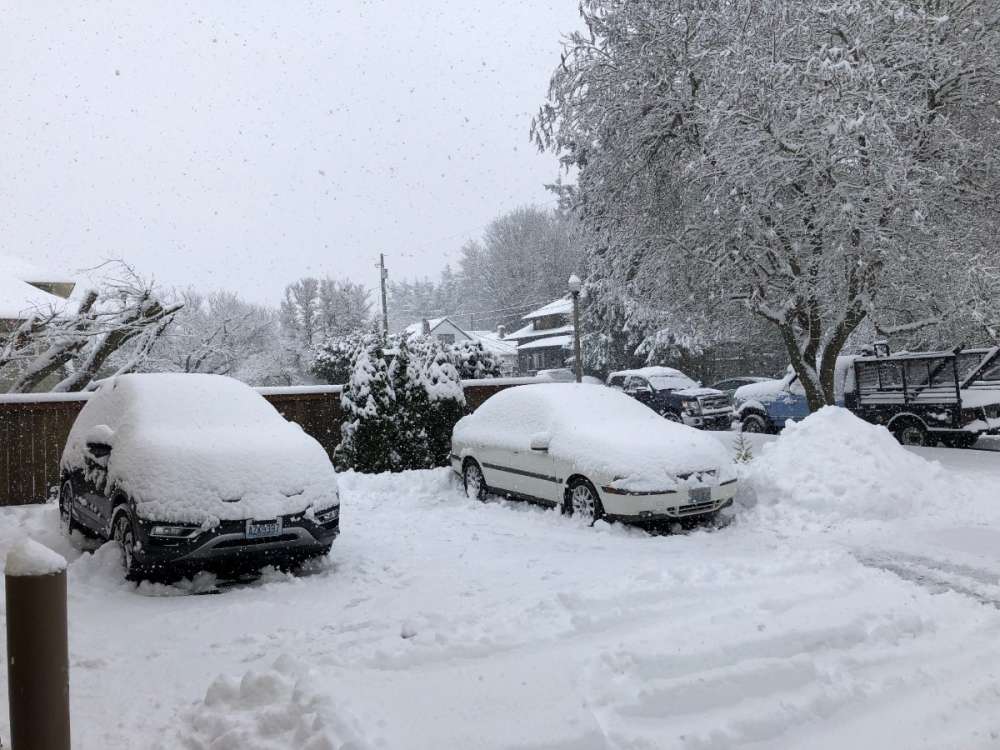
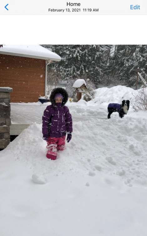
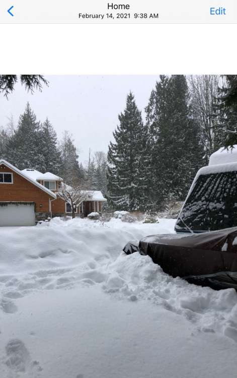
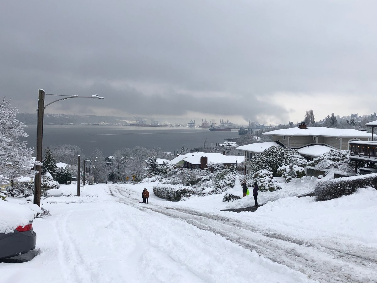
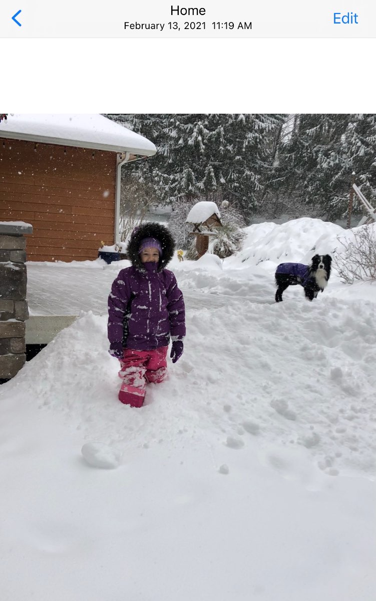
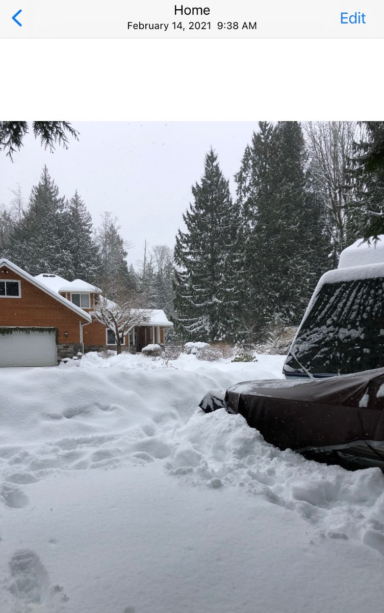
We had 13.5” of snow in about 18 hours here…with another 1.5” on 2/14. We were just far enough west that we didn’t lose any snow from the east winds. Only thing that woulda made it better was if we had maintained some cold air for a few days following the snowstorm. Was mostly gone by 2/16. We also had 0.5” of snow On 2/12.
 8 points
 -
Some small storms rolled through here this evening. Nocturnal storms are always fun!

 7 points
 -
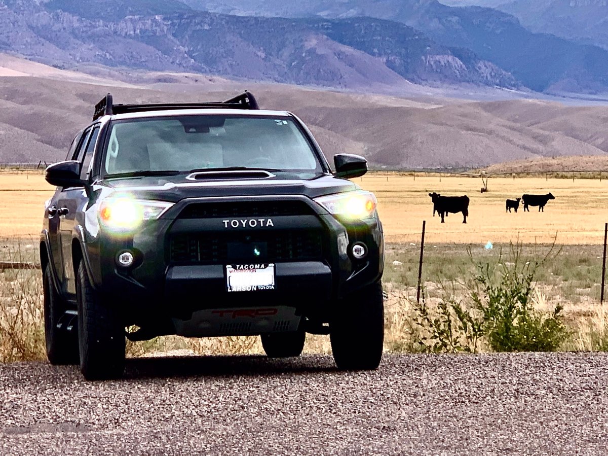
About 15 miles south of Richfield Utah. Got lucky with the storms in the background. Meanwhile on the other side of the road it looks like summer! Also a curious cow watching me…lol, he sort of goes with the 4Runner as well
 7 points
 -
Another beautiful day. 80/51 currently 74, that hemlock is not doing well at all.
 7 points
 -
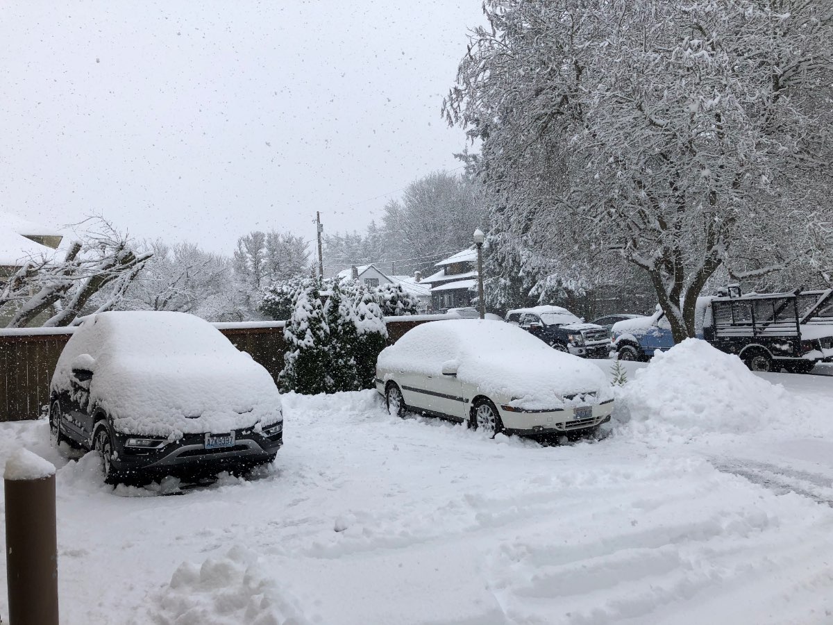
It was quick but mighty up here! Started Friday evening and stopped Sunday evening. Basically snowed all weekend, it was perfect!
 7 points
 -
Let's hope we build on this!6 points
-
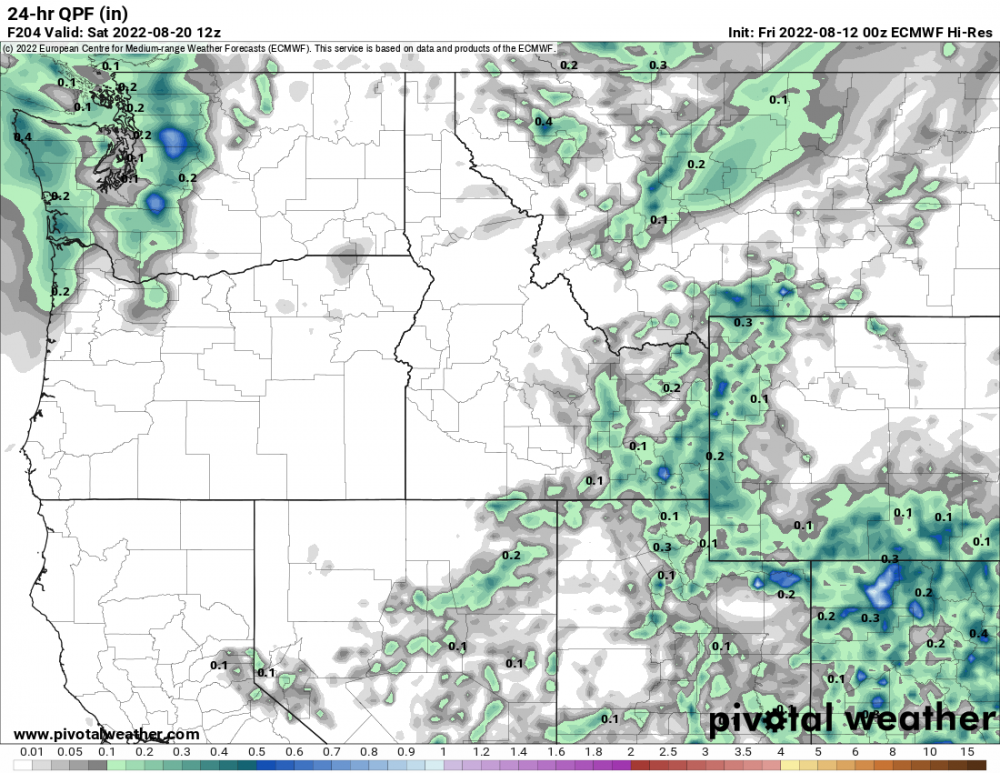
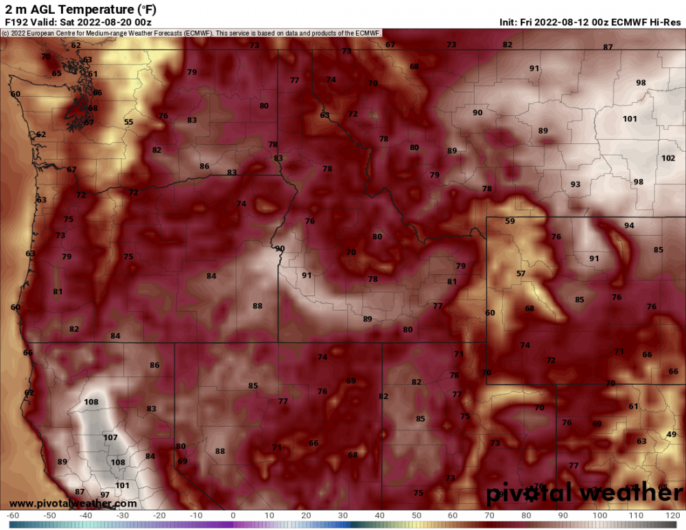
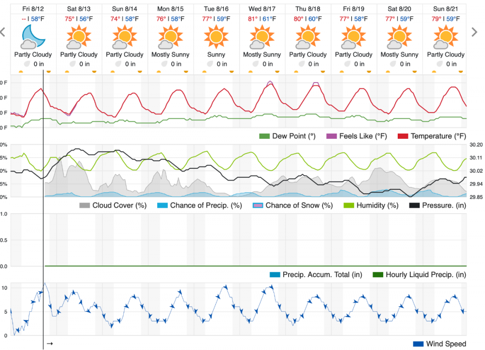
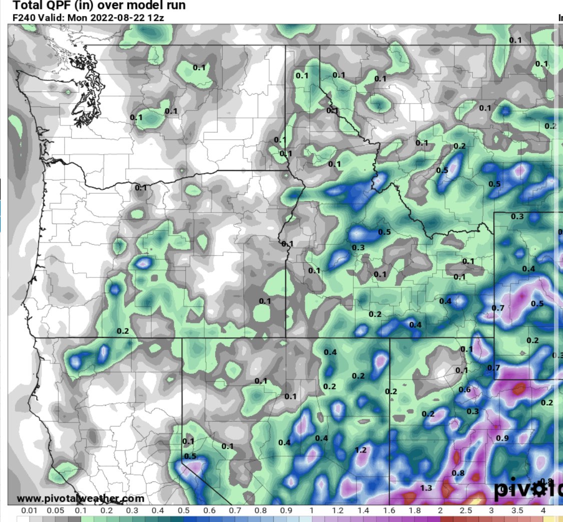
The 00z EURO says what heatwave? For PDX, next Tue-Thu it shows 91/94/88 then big crash into the low 70s on Friday with some moisture arriving, mostly into BC/Washington though.
 6 points
 -
Hi Randy, yes indeed, I have been enjoying the warm dry weather when the humidity is reasonable. I used to enjoy the very hot weather like you, but age has tempered that a bit. Looking forward to some snow and I think it will be early this year.5 points
-
Pretty morning with some instability type clouds...
 5 points
 -
Nice to see the rug get pulled on a big heat wave for once.5 points
-
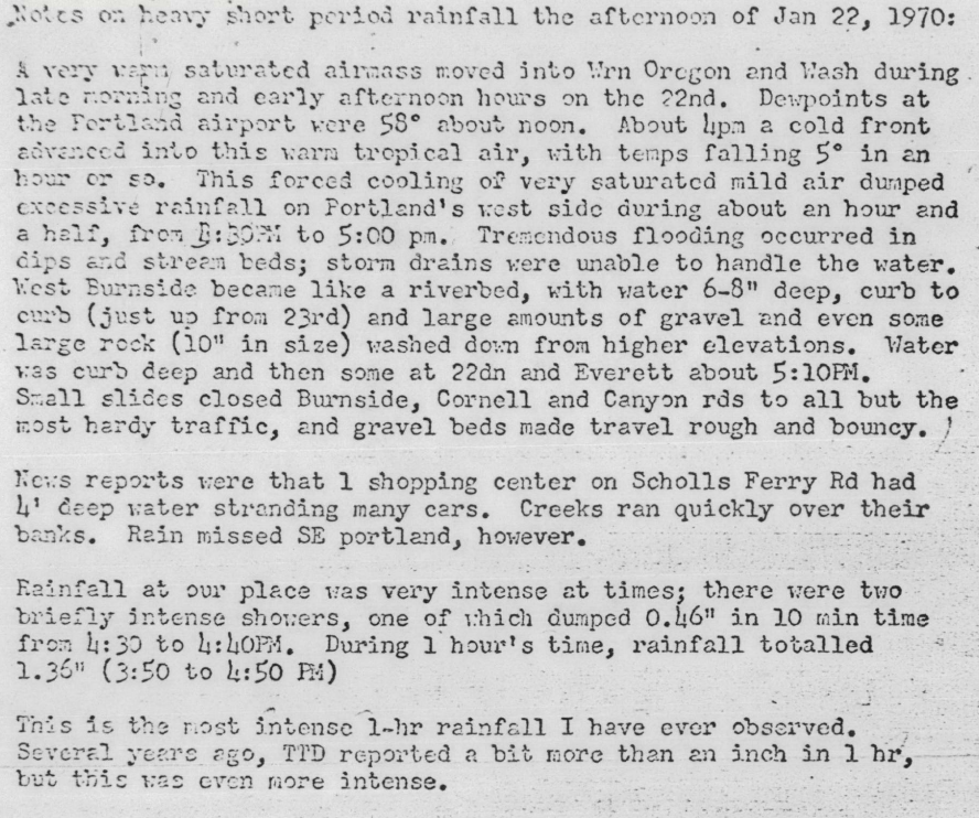
Found this interesting writeup (Station was near Sylvan):
 4 points
 -
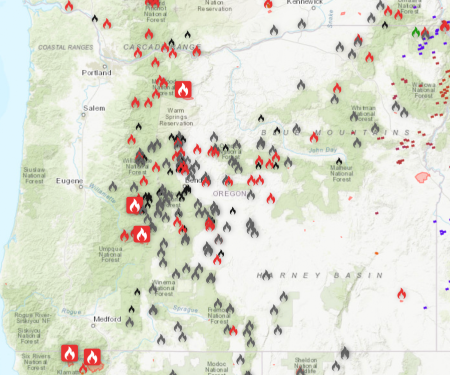
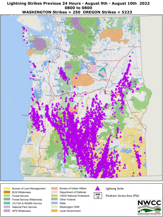
WILDFIRE UPDATE NEW Known Wildfires started today! 8/12/22 Washington - 9 (9 new fires in the state most caused by lightning in the NE corner of the state. Firefighters have made impressive progress at taking out dozens of new fires and surpassing fast moving fires. There are five large fires in the state, down from six. The total drop from 54 fires to 49.) Total: 49 Oregon - 1 (Shockingly only one new fire and crews are doing an amazing job at cleaning up fires, imaged below are all the recent fires they have put out in gray and black. There are still three large fires in the state; the Miller Road Fire, Cedar Creek Fire, and Windigo Fire. The total of fires drops from 50 to 52.) Total: 52 Idaho - 5 (Five new fires in the state all caused from lightning. Just to the west of the Idaho panhandle in Montana, lighting caused dozens of new fires. There are four large fires burning in the state. Evacuations have been ordered to homes in threat from the Ross Creek Fire north of Pocatello. The total number fires grows from 9 to 16.) Total: 16 British Columbia - 74 (Things keep getting worse in BC as lightning and other ignitors have started over 74 new fires across the province. The majority are in the Kamloops and Southeast district. The number of large fires in the province increases by one to seven now. The new large fire entering the fray is the Hasler Flats fire located in the remote Prince George district and in a remote location with the closest minor town being Chetwynd. Other major fires are the Keremeos Creek Fire which has burned since last month. Resident of the community of Ollala were just allowed to return home after evacuations yesterday. It still threatens the town of Keremeos and Cawston, but fuels for the Keremeos Creek Fire seem to be less and . Another is the Maria Creek Fire, The Briggs Creek Fire next to Kaslo, The Connell Ridge Fire, The Cummings Creek Fire, and the Weasel Creek Fire. The total amount of fires in the province increases from 84 to 118, the highest so far this year.) Total: 118 Who Has had The Most Amount of Fires (Ranked by days in which they've had the most fires, only counting days we've kept track here.) 1. British Columbia - 18 days with the most wildfires 2. Oregon - 2 days with the most wildfires. SMOKE UPDATE Onshore winds are pushing smoke eastward and have really helped clear out most of the region. All areas are seeing good quality and good visibility except for some valleys in the British Columbia interior, and the continued moderate to unhealthy air in Grants Pass, Medford, and Klamath Falls, all due to California wildfire smoke. Bend, Oregon is also seeing moderate air quality due to smoke. By Saturday, most of the smoke will be well east of Washington, Oregon, lower mainland BC and making it's way east over Idaho and Montana. Medford might get some relief by Sunday if winds do indeed shift south and blow smoke towards California's Inland Empire. Oregon crews have taken out many fires recently, note the black and gray icons. A British Columbia crane unit for a fire department burned the other day due to the wildfires, thankfully no crew was injured and got away.
 4 points
 -
As far as snow goes-- nothing can top 1/10/17. 20 inches of heavy, powdery snow in about 12 hours? Pretty extraordinary for this region4 points
-
Feb 2021 was an awesome nugget of a snow event here. Feb 2019 may have been a juggernaut in total, but Feb 2021 still holds the record for largest individual snowstorm at my place. Kind of got insane at times, and we were even in the east wind shaft zone a bit.4 points
-
I am indeed. Daiquiri, summer breeze, and rum in coke #3 so far today.
 4 points
 -
GFS was the last holdout for extreme heat next week but 12z is much more in line.4 points
-
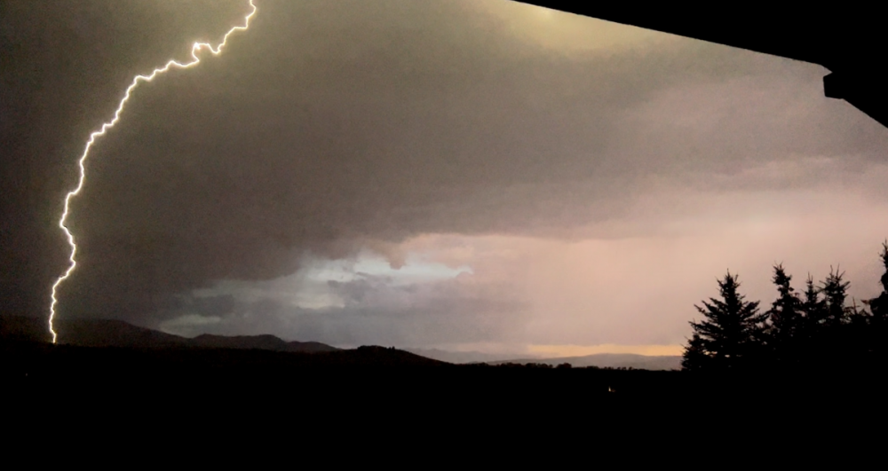
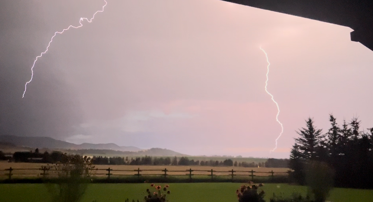
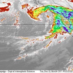
Lightning strikes from our thunderstorms earlier, I think it ends before that storm hit the Sound though:
 4 points
 -
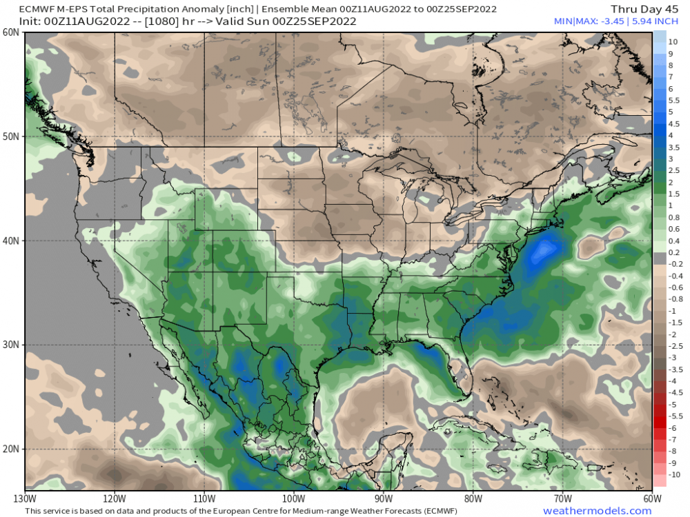
Your forecast has me dreaming of October which is my favorite month of the year. Check out the Euro Weeklies 46 day forecast, if this snow were to happen in northern Canada our fall cold fronts would have much more of a bite than they've had the last several years!4 points
-
It is a nippy 53F currently under deep blue sunny skies w/ no humidity at all. Absolutely gorgeous. Highs today in the 70s. Weak disturbance coming tomorrow might sparkle a few clouds and scattered rainshowers, but no real biggie. Highs will managed to climb only to near 70F on Saturday and 72 on Sunday. A taste of Autumn is certainly in the air here in S MI.4 points
-
Liking the trend of the ECMWF. Nice cool trough late next week / next weekend.4 points
-
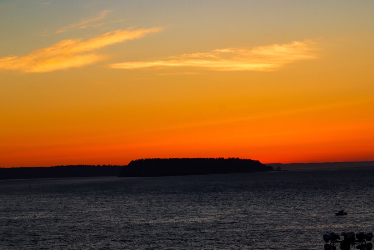
Hope everyone had a nice Friday. 63F and a nice sunset tonight.
 3 points
 -
Weather app looking all 80+ degrees past Saturday. Gotta stock up on more ice cream and iced coffee then. In other news, trying to convince the family to shift our Philippines vacation from January to July, avoiding dry season for wet season. Why? I want real thunderstorms again, I've missed it and it's insane in the tropics. Also that dry season absolutely sucks, oppressively high heat index with full sun and high humidity there for weeks.3 points
-
Just checkin' up on the forum and reading what I've missed. This reminds me of when I would get postblocked on Facebook for 30 days because of memes.3 points
-
4" hail in July 1995!3 points
-
Wow... in April 1968, the Bethany COOP station recorded a temp of 23 degrees on the 13th! PDX also recorded a freeze but only got down to 30 degrees. Hillsboro dropped to 26 that day. Looks like a cold month, an avg temp of 47 degrees, but not too wet, only 2.37" of precip. There was also a frost in early May. The station did have a 91/49 day and a 93/56 day in late June too. https://www.ncdc.noaa.gov/IPS/coop/coop.html?_page=2&state=OR&foreign=false&stationID=356747&_target3=Next+>3 points
-
A few late reports being added to yesterday's storms.3 points
-
December 2021 was pretty fun here too. IMG_5764.MOV3 points
-
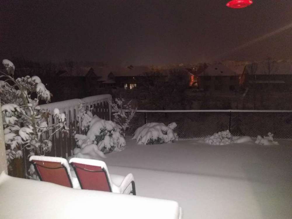
Here's a photo from Jan 2017. The table in the bottom left is actually fully undercover, the wind just blew the snow on top of it.
 3 points
 -
3 points
-
GFS caving to the ECMWF on the trough late next week.3 points
-
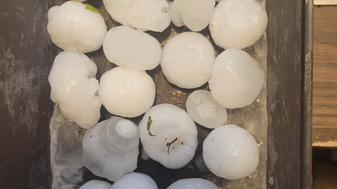
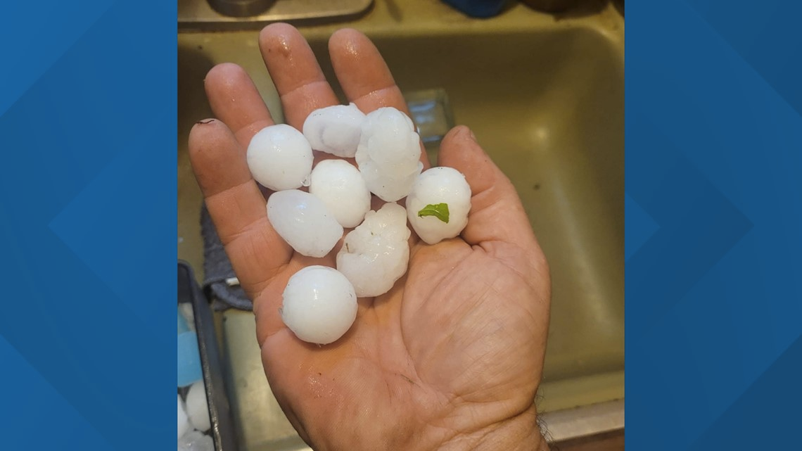
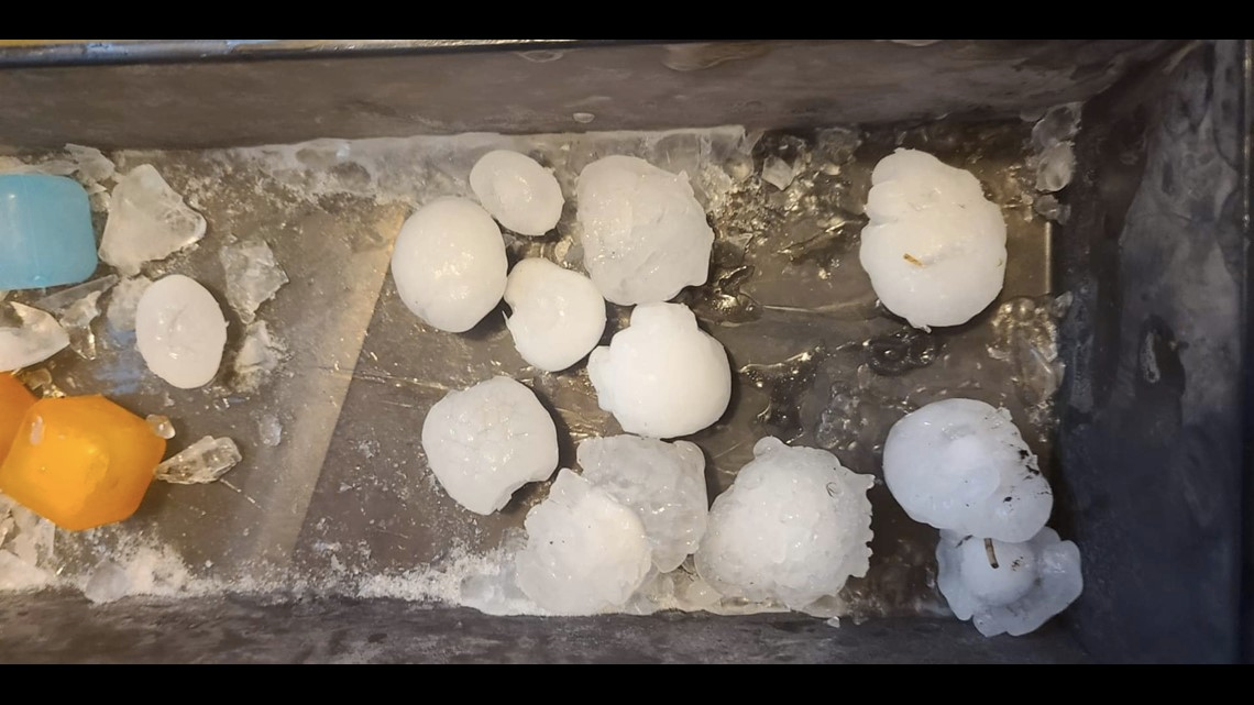
Some of those pics from yesterday were certainly larger than golf ball sized.3 points
-
@Andie, the EPS Weeklies are in lock step with the JMA weeklies and suggest the next 45 days to be wet, wet, wet...nature will fill up those lakes and reservoirs! #4CornersMonsoon....Boom!
 3 points
 -
Representing Tacoma from all over the western US!2 points
-
The 540dm AND the 534dm contour!2 points
-
Hello old friend.2 points
-
Nice day. We hit 75F, currently 74F. Strangely my station is the warm spot of all the stations located around me this time. Others are in the low 70s with one being 69F.... nice. The forecast looks like our temps are going to bump up a few degrees and start getting hot. Luckily not too horrible... even if I can't get the temperature below 81F inside....
 2 points
 -
It all flips around one day and mother nature will deliver the goodies for all of us this winter!2 points
-
Was looking at old screenshots... Feb 2021: I wish this had happened!2 points
-
And High Solar, High Sodium/BAC (Phil, still drinking?)2 points
-
Down in southern OR I think it was just far enough north to give Southern OR up to around Salem a very warm July, a decently warm July in Portland and cooler towards the Puget Sound. Salem saw their hottest month on record in July 2021.2 points
-
All I can say about the Atlantic is WTF? Not even anything close to being anything of interest. There is definitely something driving the patterns that is overruling the MJO.2 points
-
There's a 6500 foot mountain right next to where I go mining and in the years I've been doing that the only month there hasn't been snow up there is August.2 points
-
The official H/L yesterday at Grand Rapids was 80/60 there was a reported trace of rain fall and 88% of possible sunshine. The overnight low in MBY so far is 54 while at GRR the low so far has been 52. In the UP the current temperature at Marquette is 39 so it was a cold night in parts of Michigan. At the current time with this sun now poking is self in the east is 54. For today the average H/L is 81/52 that is down from yesterday as we start our downward trend for H/L’s that will continue. The record high for today is 95 set in 1988 and the record low of 45 was set in 1954. The only chance of rain in the next week looks to be on Saturday as the rest of the week looks to be dry with temperatures just a little below average.2 points
-
Happy Friday! Today will be a travel day for me as we head back to the PHX valley. There is a really good chance of numerous storms on our way back. Hopefully they won't be to bad on our path. Meantime, there appears to be a really good shot for some soaking rains where some need it most. The battle among the models is interesting... 0z Euro... 0z UKIE... Is the 0z GFS out to lunch??? Lastly, the rain dances shall commence post 20th for our hearty Texan @Andie...I had a good feeling the worst of summer was just around the horizon when I saw the JMA not back down on the MJO forecast. Good signs!
 2 points
 -
WILDFIRE UPDATE (Lightning has caused havoc in every region of the PNW) NEW Known Wildfires started today! 8/11/22 Washington - 25 (Lightning has sparked dozens of wildfires in the state. Earlier in the summer fire crews were on top of everything, but as more fires spark, the harder it becomes. 25 new fires in the past 24hrs and 38 in the past 48hrs. A new blaze is quickly spreading near the town of Grandview and could be a risk if not contained. Lightning caused several fires to spark northeast of Kachess Lake in a remote, rugged area. Lightning also sparked several new fires northwest of Lake Wenatchee. WA Fire Crews are optimistic about fully putting out the Cow Canyon Fire and Vantage Highway Fire by the end of the week. The cluster of fires, high up in the Gifford Pinchot National Forest we reported yesterday are growing at an unfortunate rate and could become a large wildfire. Speaking of large wild fires, the state in just the past few days went from having only 3 large fires to now having six. The new large wildfires are the Mohr Fire north of East Wenatchee and the Canyon Road Fire near Grandview. A new cluster of lightning induced fires also sparked around the large Williams Lake Fire making things worse for firefighters. The total increases from 32 to 54, the most fires at one time in Washington so far this year.) Total: 54 Oregon - 14 (14 new fires across the state. There have been 38 new fires in the past 48hrs. Thankfully dozens of fires have been put out in the past 24hrs and great progress has occurred in the large fires south of the Oregon border in Northern California. There are three large fires in the state; the Miller Road Fire, Cedar Creek Fire, and Windigo Fire. The lightning strike are unfortunately hitting the driest parts of the state and in areas where wildfires are already burning, simply increasing the amount of fire. The total of fires in the state has seen a big drop from a record high (this year) of 78 to 60.) Total: 60 Idaho - 4 (Four new fires in the past 24hrs, and pretty spread out around the state. Some good news as the large, fast burning Michaud Creek Fire near Pocatello was put out in the past 24hrs. This brings the large fires in the state down from five to four. The total number fires grows from 5 to 9.) Total: 9 British Columbia - 43 (BC Fire Mapping has been pretty off-pace this year, hence the huge discrepancies at times. Nonetheless, there was an astonishing 43 new fires in the province. Most appear to be lightning caused. There are now six large wildfires in BC, one less than yesterday. The total amount of fires in the province increases from 58 to 84, the highest so far this year.) Total: 84 Who Has had The Most Amount of Fires (Ranked by days in which they've had the most fires, only counting days we've kept track here.) 1. British Columbia - 17 days with the most wildfires 2. Oregon - 2 days with the most wildfires. SMOKE UPDATE Onshore winds are pushing smoke eastward and have really helped clear out most of the region. All areas are seeing good quality and good visibility except for some valleys in the British Columbia interior, and the continued moderate to unhealthy air in Grants Pass, Medford, and Klamath Falls, all due to California wildfire smoke. Models show smoke may flow aloft, northward from California a little on Friday, but it should cause no issue. By Saturday, most of the smoke will be well east of Washington, Oregon, lower mainland BC and making it's way east over Idaho and Montana. Medford might get some relief by Sunday if winds do indeed shift south and blow smoke towards California's Inland Empire.2 points
-
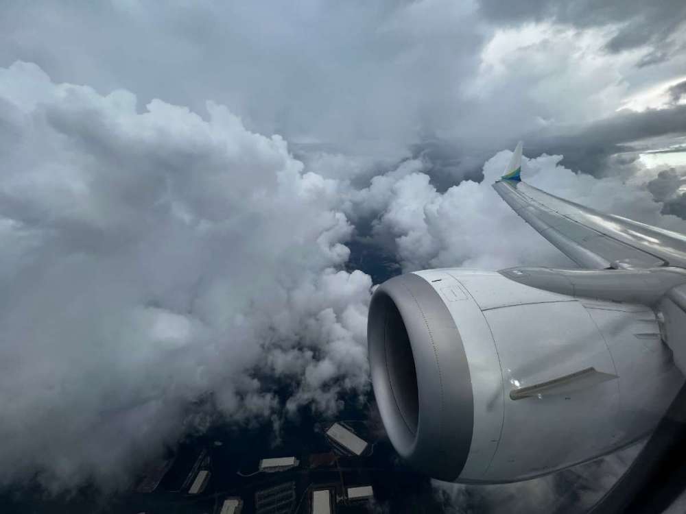
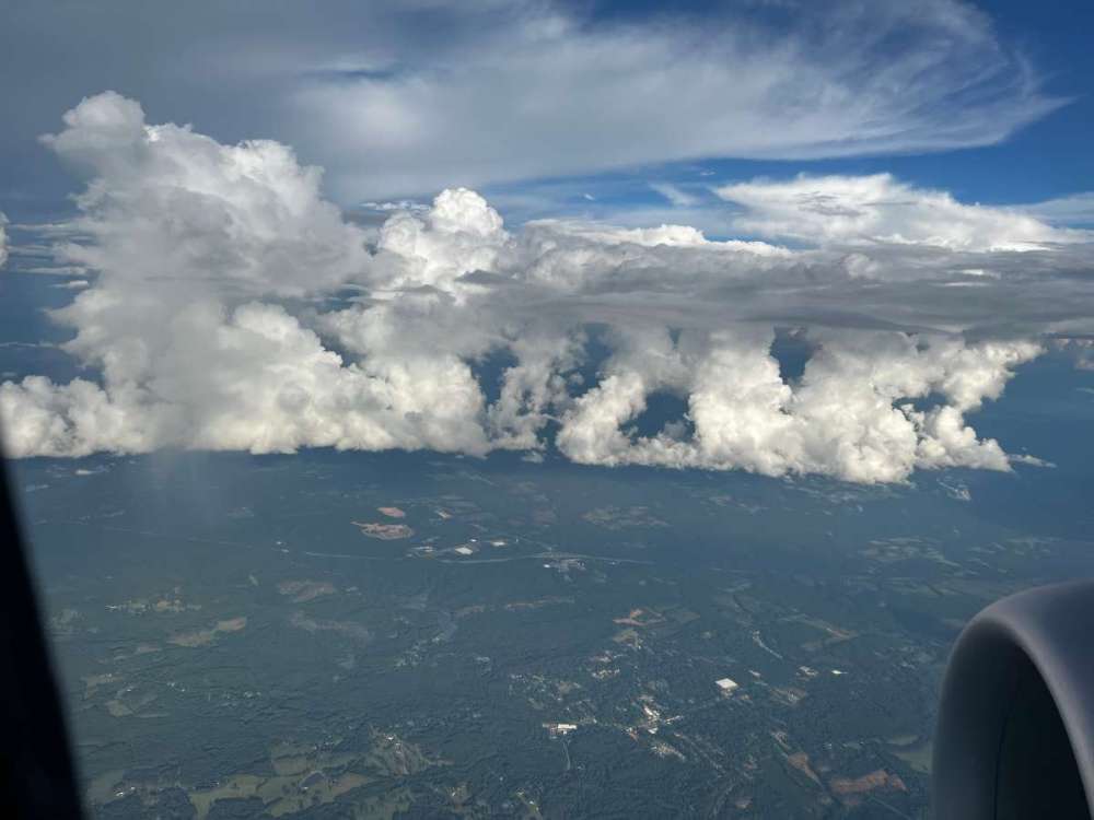
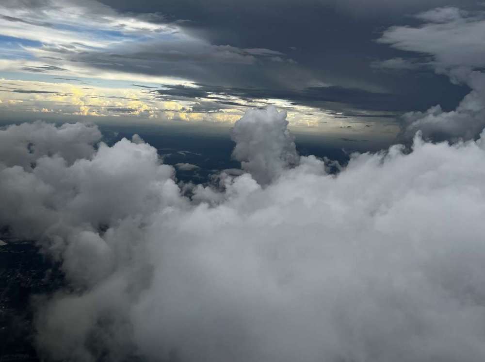
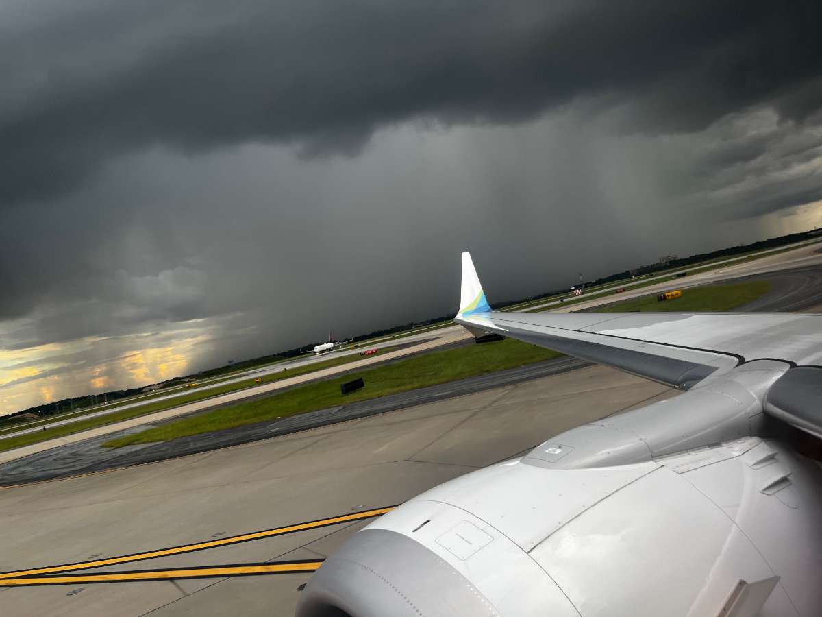
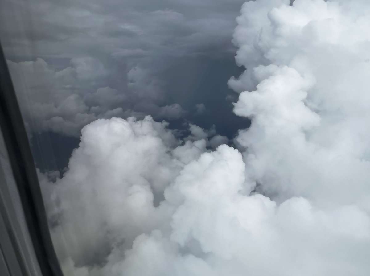
First time being able to get online since into the ATL Tuesday night. Looks like the storms were not too impressive in Bellingham, but sounds like other parts of Puget Sound had some fun (I haven't ha a chance to go throgh the posts. As for the last part of my journey, we flew through some incredible cloud formations as we worked our way in to the airport. After we landed, I could see there was a finger of intense rain extending up towards the airport on radar, that I got a picture of as we were taxiing. Right as they were opening the door and driving the baggage loading belt up to the plane, there was a huge flash of lightning, and the skies opened up. The ground crew scrambled for cover, and we ended up waiting over 2 hours to finally get our bags. It was raining so hard I could barely make out the shape of an airplane that had been pushed back and was sitting in the alley waiting to taxi

 2 points


This leaderboard is set to Vancouver/GMT-07:00