
Leaderboard


.thumb.jpeg.e3014abf99ef08a9f9ac2c0cd31b485b.jpeg)
Popular Content
Showing content with the highest reputation on 02/17/24 in all areas
-
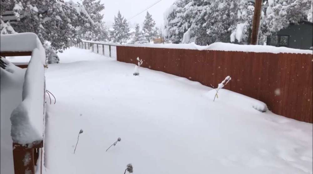
Up to about 9" of snow depth now! 22 degrees currently and a high temp of 28. Here's a few pics of the snow from earlier Edit: why do my pics always get so blurry after I upload them...

 12 points
 -
11 points
-
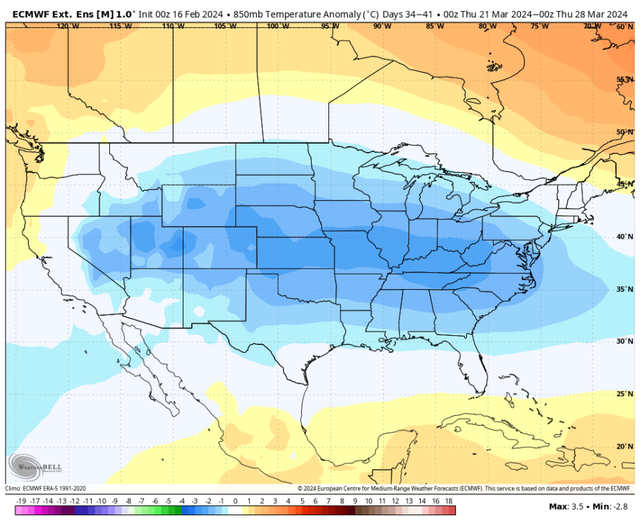
I'm mildly intrigued by the end of the month and the first week or so of March, but at the end of the day all eyes are now turning towards the potential for one of the strongest Ninas on record. I've noticed quite a few CFS ensemble members now go literally off the chart with it. The MEAN is now below -2.0 by November!8 points
-
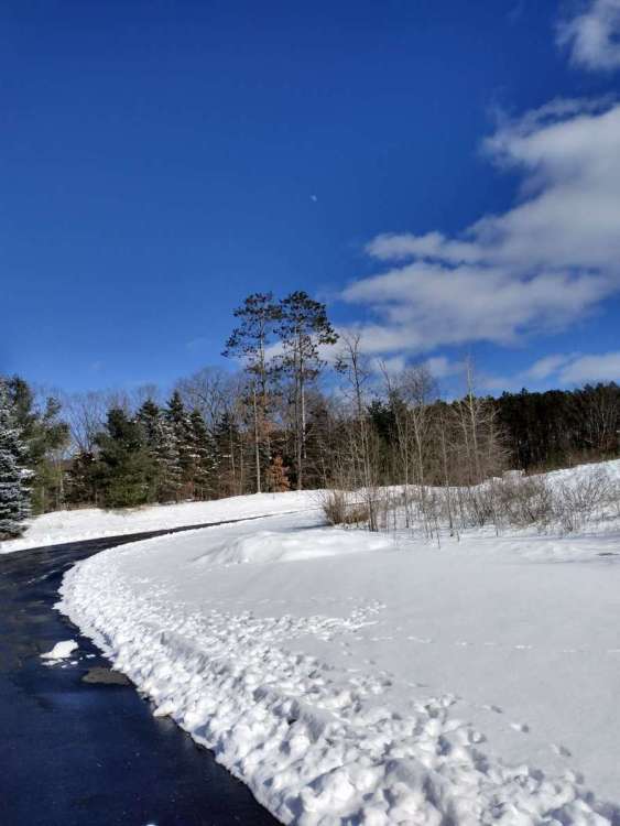
Surprisingly snowy in Bend this morning. Supposed to change over to freezing rain this afternoon but pleasantly surprised with about 1.5” so far. 10” for the month and 32” for the season now.
 8 points
 -
8 points
-
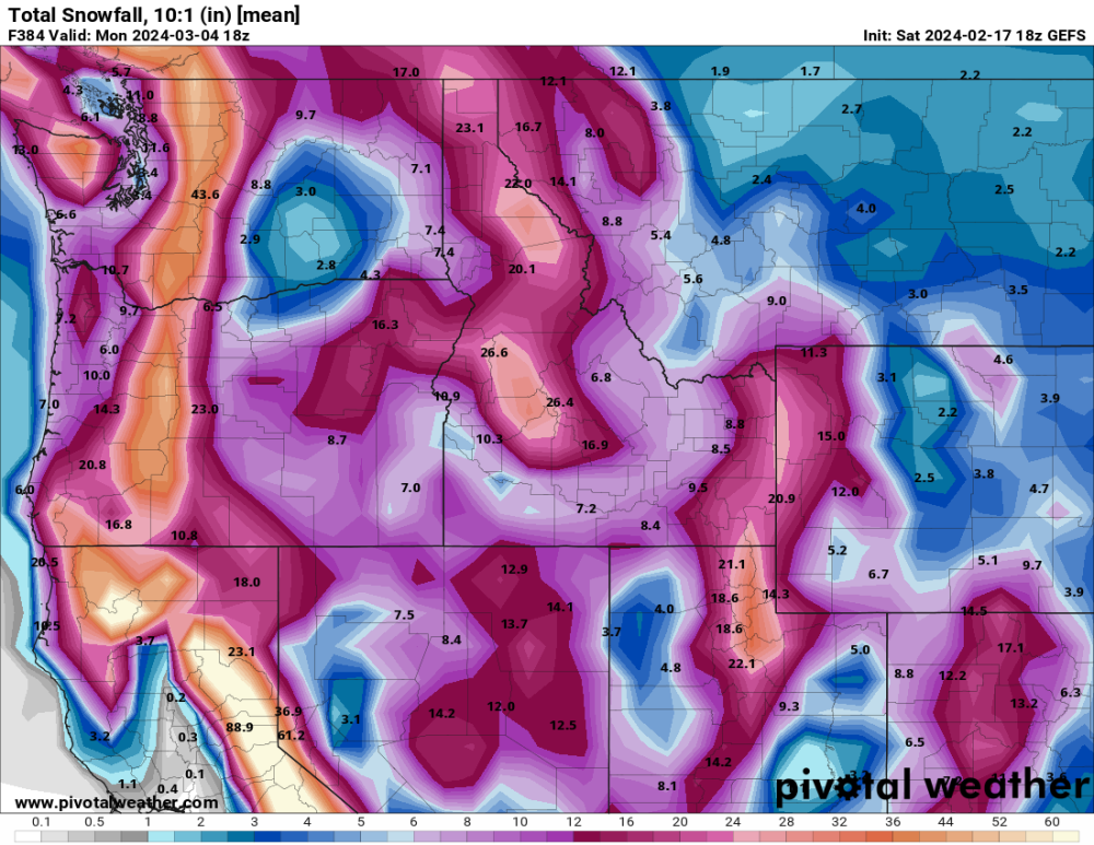
18z GEFS was pretty snowy
 7 points
 -
That’s an Arctic Blast signature with all the snow. The first go around will be a warning shot with cold onshore flow. But at day 10 of the 12z EURO it shows Arctic air making its way down into Central BC. The ingredients are there for some really cold air to make its way down into the PNW. It remains to be seen however if it gets watered down since we are getting close to March now.
 7 points
 -
Best snow signal of the entire winter at that lead time.7 points
-
Down right chilly this morning as temps dropped well below expectations. It's currently 11 with some light snow cover from yesterday morning and the forecasted low for mby was 20. It was not a bad storm for some there are some nice snowfall totals to my east.7 points
-
I'm sold on lowland snow already. Details are totally unknown of course.6 points
-
Good improvement on the 18z GEFS for snowfall.6 points
-
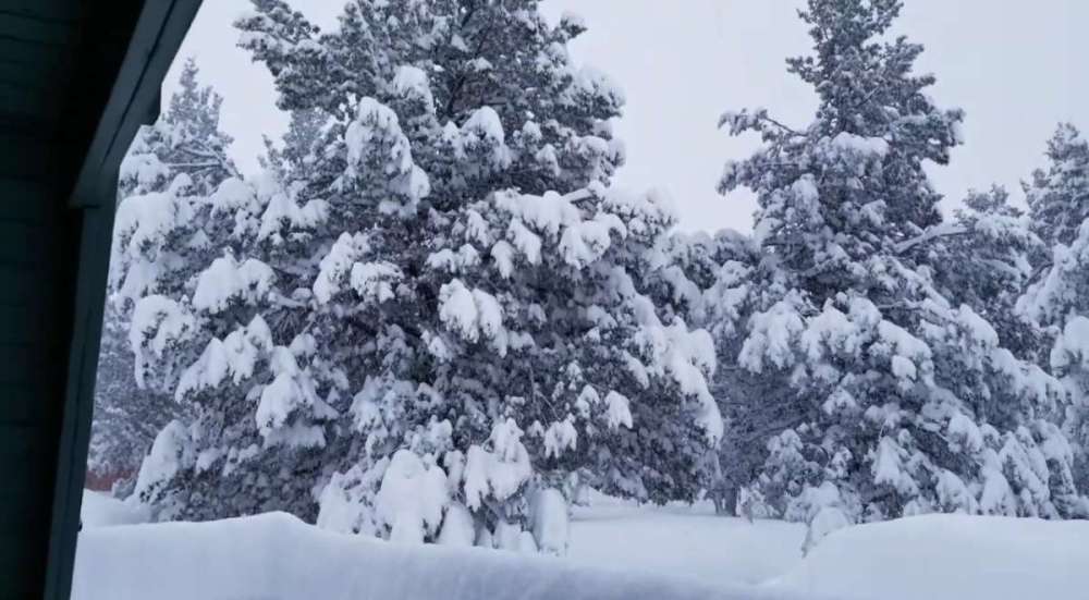
Got up to 28 but cooling down as it begins to lightly snow again. Hoping for an inch or two instead of ice. These deer have been hanging out a lot here recently.
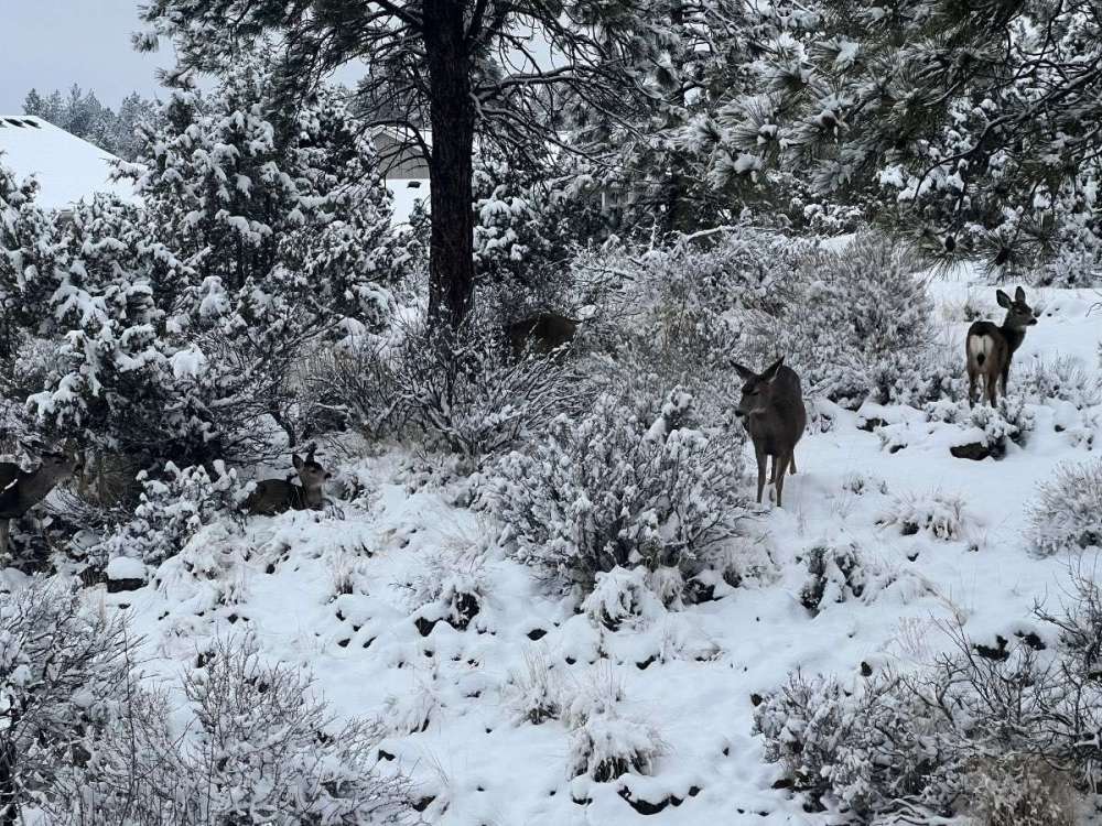 6 points
 -
There were some benchmark cold temps with the late Feb event in 2011. I believe it had one of the coldest high temps on record that late at PDX, and the low of 5 that OLM saw on 2/25 was by far the latest they have ever gotten that cold. Next closest was the low of 5 on 2/6/89. EDIT: The low of 18 that PDX saw on 2/26 is the latest they've ever gotten that cold. Next closest was last year on 2/25.6 points
-
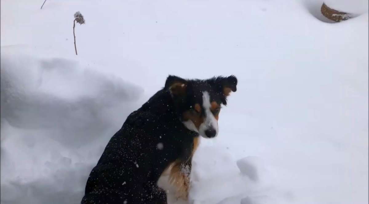
Dog walk..
 6 points
 -
Even the EPS mean shows over 6 inches here. Noice!6 points
-
3 day EPS control snowfall when the hammer drops.6 points
-
Godzilla Niña.6 points
-
The sky is puking frozen H2O. Legit rates. IMG_0437.mov6 points
-
OMG we did it!5 points
-
Yeah it's incredible. Like Tim gets up there with a big flame thrower at night to protect the palm forest.5 points
-
That’s becoming quite a few pepto members5 points
-
Dec 2021 was a real favorite for me too. Nice run of cold and snow on the ground.5 points
-
5 points
-
We will see about later this month but I feel like something decent will happen in the western lowlands at least for this late in the season. I also am feeling a big winter like 2010-2011 next year.5 points
-
5 points
-
I know Phil thinks I’m full of teleconnection crap…But whenever we go that negative with the PNA (if the forecast hold true) I usually see a good to great snowfall at least 90% of the time. Its coming.5 points
-
20 degrees, the temperature is sllllooowwwwly going down. Quite a bit cooler than forecast which is always a good sign, and it just started to snow. Some models are calling for freezing rain tonight and tommorow instead of snow, but it's still possible for it to be all snow. Personally I'm forecasting snow, but time will tell. Heres a pic of the snow falling in the streetlight, looking good so far! Good night.
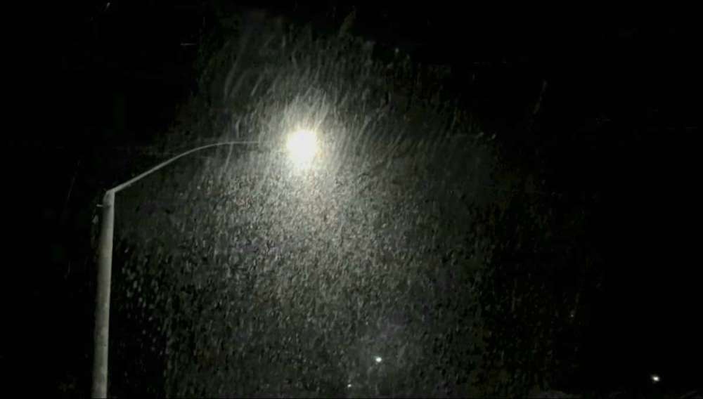 5 points
 -
Significant lowland snow event in the overrunning ahead of the low at the end of the run.4 points
-
Wow. BULLISH!4 points
-
Good change on the GEFS with the higher heights over the northern GOA.4 points
-
That first one is a big deal though. Siberian origins with the cold on that.4 points
-
4 points
-
Yeah, no matter what this winter is a W for us and continues the streak of at least decent performances. We managed a historically cold airmass and overall we will also stave off being the focus of the warmth, unlike a year like 2014-15 or 2002-03 where we were ground zero. Also looks likely that we're going to at least have another crack at lowland snow at a time when Ninos traditionally favor spring-like temps.4 points
-
Won’t get half that but fun to look at. been snowing all day here lightly, temp made it all the way up 27 imby and now down to 25 again with the snow starting to pick up a little more. Everything is still beautiful outside as the snow only melted on some of the main roads around town. Looking like another couple inches tonight before we finally warm up tomorrow. This is 4 straight days with snow falling. Probably nothing else until the end of the month which looks decent again here. Pffft, what El Niño?4 points
-
Yeah, if the January 2011 event had worked out…then it would’ve been the winter of the century past 2008-2009 and 2018-2019. 2 really good events and a near miss on a 3rd one. That miss in 2011 was pretty sad was forecast to be a week straight of snow and cold.4 points
-
Really hoping for a very active winter. Wet, wild, and wintry!4 points
-
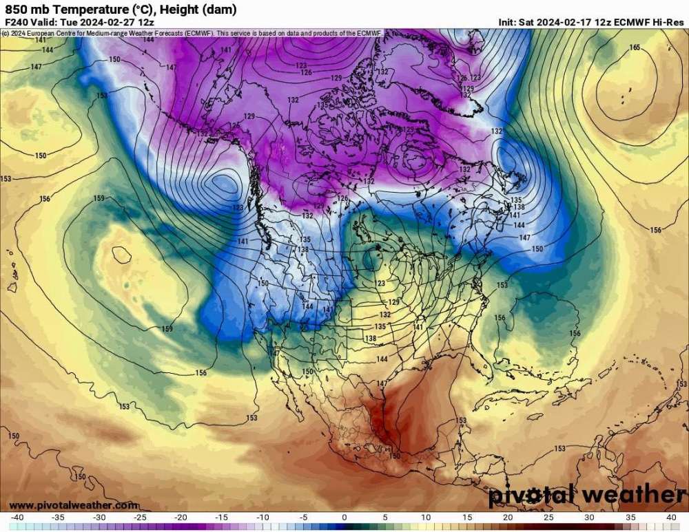
12z EURO at day 8 looks poised for some very cold onshore flow day 9-10.
 4 points
 -
That's the best snow signal Seattle has had all winter. Maybe we have one last chance... Edit: Lol, didn't realize someone else literally said the same thing, but it's true!4 points
-
I'll be in San Fransisco later today to go and visit my niece at University of Berkeley (Law School). Looking forward to that. I'll post pics. It will be my first time visiting there, so that should be fun.4 points
-
March should provide some atmospheric fireworks...pretty good signal for an eventful Heartland...4 points
-
High Pressure is in full control this entire long weekend...highs will approach 80F by Mon & Tue of next week and upper 70's over the weekend with light winds. Can't ask for anything better this time of year when avg temps are 71F. Just blue skies and sunshine. Grass is growing and the landscape has begun to turn green. It's starting to feel like Spring is in the Air around these parts. The sun is setting past 6pm (6:13pm) as the days are getting longer ever so slowly. Our pool is packed with all the snow birds that have flocked into the valley. I still have an itch to track one more Winter or Spring storm...we'll have to see how that shakes out, but in the meantime, I'm going to soak up the vibes in the "Valley of the Sun"!4 points
-
So far, the big stories for the winter of 2023/24 have been the mild almost snowless December. The 2 weeks of cold and snow in January saw not only the coldest temperatures of the winter, but a total of 30” of snowfall in just two weeks. And now February has had a very warm start. For the winter season we are running near the record warm meteorological winter of 1921/32. The mean for the meteorological winter of 1931/32 was 33.9 so far this winter has a mean of 33.5. Here is a month by month breakdown of the meteorological winters of 1931/32 and 2023/24 so far. December 1931 had a mean of 35.8°, the high for the month was 55 and the low was 17. There was 7.1” of snowfall. December 2023 had a mean of 38.3 the high for the month was 58 and the low for the month was 22 there was just 1.3” of total snowfall. January 1932 The mean was 34.2 the high for the month was 58 and the low for the month was 5 there was just 3.2” of snowfall. January 2024 had a mean of 27.1 the high was only 40 the low for the month was -5 There were many days where it did not get below 30. The was a lot of snow in a two-week period when over 30” fell the month ended up with 31.3” of snowfall. February 1932 had a mean of 31.8 the high for the month was 64 and the low for the month was 13. There was 5.2” of snowfall. So far this year the 1st 16 days February mean is 35.1 that is a departure of +10.0. The highest so far is 59 and the lowest so far is just 21. There has been 5.5” of snowfall and 0.53” of total precipitation. In 1932 for the whole month of February the mean at GR was 31.8 the high for the month was 64 and the low for the month was 13. There was 5.2” of snowfall the total precipitation was 1.16”. The next 13 days will decide if this winter will be the warmest meteorological winter.4 points
-
A lot more dawgs in the EPS mix.4 points
-
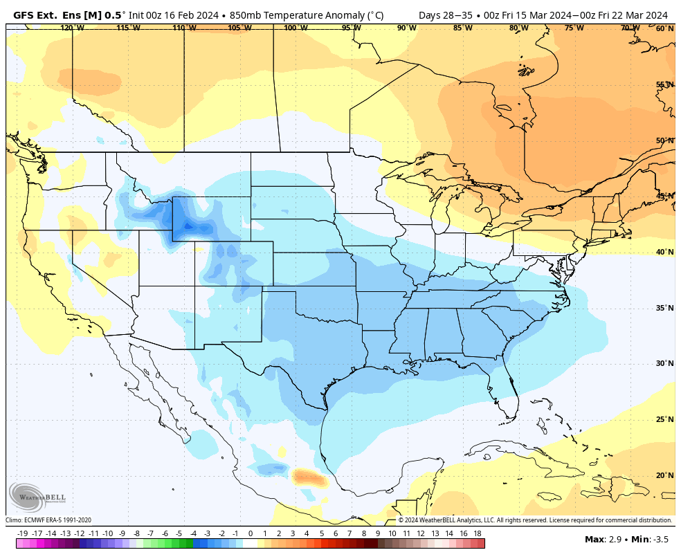
Pretty widespread cold and wet signal for mid/late March on the latest Euro weeklies and GEFS extended. The groundhog may have seen an early spring but I don't think that's going to be the case.
 4 points
 -
That is a helll of a strong signal for that far out.3 points
-
I already told my personal arborist.3 points
-
Recent runs of the GFS have been teasing a blow torch at the end of the month, with 70s into Iowa (and lows in the 60s). As good as that would feel, that kind of early warmth, on top of the already-mild winter, would wake up plants way WAY too early. My daffodils always pop up just a bit, regardless of how cold winter is, but this year they are up a few inches because of the consistent mild weather. I would greatly prefer that we stay in the 40s and 50s.3 points
-
3 points
-
3 points
-
Great trough on the EURO with round #2 on the way.3 points


This leaderboard is set to Vancouver/GMT-07:00