
Leaderboard


Popular Content
Showing content with the highest reputation on 11/17/16 in all areas
-
But then I remembered Trump is now President-elect and I decided life is worth living.4 points
-
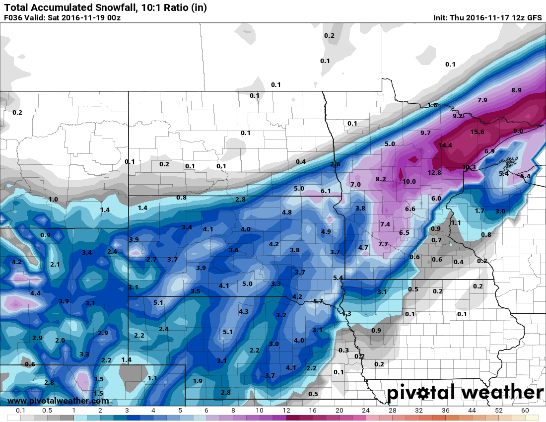
Wasn't going to say anything but now I will. I noticed last night it started to drift a little more south and east. The 12z run is now the furthest it has been yet!! I might be in line for 1-3" of snow! This is incredible, we had a record high of 79 yesterday and we will be seeing highs tomorrow 30 degrees colder!
 4 points
 -
So much nervousness coming from this board these last few days! Many of you have already leaped off the ledge while meteorological winter is still 2 weeks away! I remind you what things looked like in the beginning of December 2008. Things were much more dire than the pattern that is on the horizon over the next 10 days. I'm with Snow Wiz on this one, things are aligning well for a mid December through January blast. 12z ECMWF continues the trend of moving more and more cold air over to this side of the globe. Very positive steps to seeing something great December through January. Patience everyone!3 points
-
A see saw temperature pattern wouldn't surprise me in December. The big news right now is the shorter range looks older.2 points
-
I'm a card dealer at a casino, and one of our dealers hates snow. He is one of those guys that talks way too much, and says the same things over and over. Lately all I hear out of him is telling the players "no snow, no snow". I want us to get absolutely burried and see it bite him in the a**2 points
-
Jim Flowers is calling for lots of snow. Thinks we have a major pattern change coming first week of December with lots of cold and snow through New Years. He is actually a pretty accurate long range forecaster. Hope he's right, I've been dying for a front loaded winter for years! https://www.facebook.com/JimFlowersForecaster/videos/605288142991839/2 points
-
Bastardi is almost like an east coast version of Jim. Endlessly optimistic regardless of how terrible things look.2 points
-
Yeah and it totally ruined my day2 points
-
Might as well... It would be kind of a shame for what was an epic first half of the month to get lost in mediocrity due to a chillyish second half.2 points
-
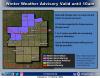
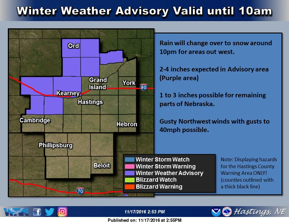
I have just been put in a winter weather advisory for 2-4 inches. This is an unexpected surprise.
 2 points
 -
I know!! If it wasn't so much work I would go to the Nov. 2008 archives and grab a couple of posts of people leaping off the edge at this time that year!2 points
-
Well, the years SW likes to reference that had multiple "warning shots" before a huge event (usually in January) typically didn't see them until December. Sometimes mid December. I think we're definitely moving in the right direction. Halfway through November...patience.2 points
-
So, if the equatorial/tropical response to the strawarm is coherent and successful in reigning in the Hadley Cells and lowering the wavenumber, the door opens for something significant in December, and possibly beyond. However, if the wide Hadley Cell background state is just too much to overcome, and the response fails or fails to complete and/or cycle, both December and January could be very problematic over the NPAC. Will have to watch these developments closely. In my opinion, the importance of getting this right cannot be understated.2 points
-
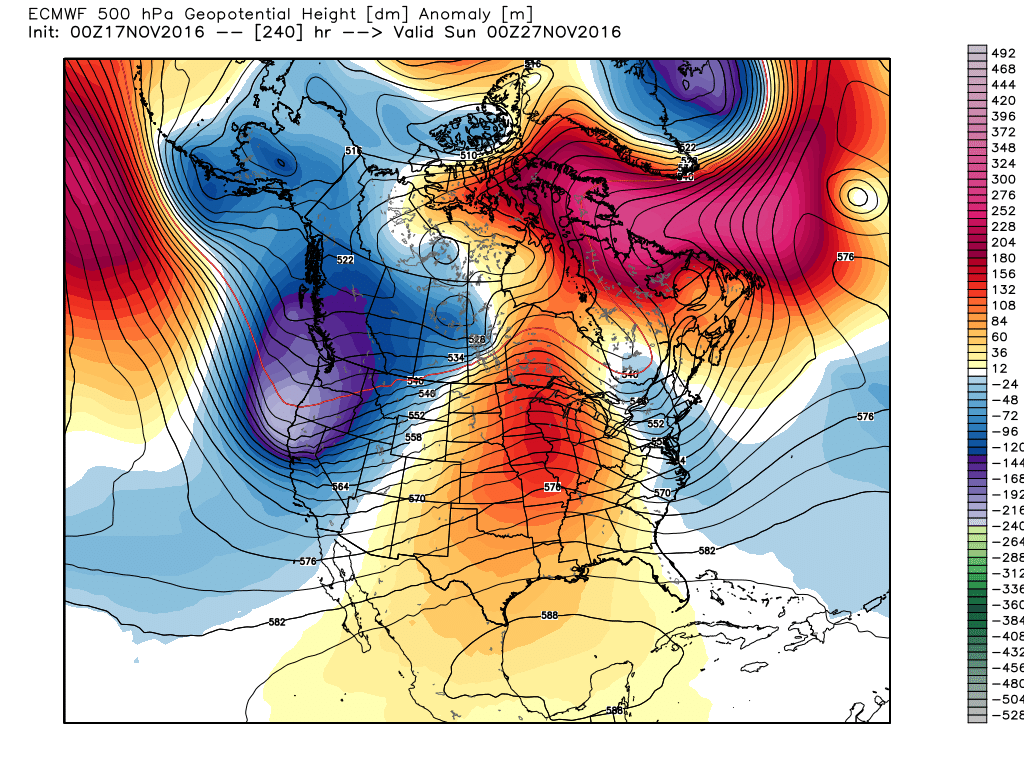
Despite the aforementioned Hadley Cell issues, there's some good news with regards to the latest stratospheric developments, and I'm starting to think these developments will be crucial to the upcoming winter. The GEFS/EPS members are almost in unanimous agreement with a partial to complete wind reversal @ 60N, at/below 10mb, with a partial to complete destruction of the PV looking increasingly possible. This will assist in not only maintaining high latitude blocking, but will also act to cool the equatorial tropopause/lower stratosphere, which will favor an increase in near equator convection relative to off equator convection. This may act to contract and tighten the Hadley Cells equatorward, and open up the door for a NPAC regime change in December. Usually in cases like this, I'd expect the EPO to tank, and that broad/flat anticyclone south of the Aleutian to disintegrate. Here's latest GEFS forecast (Hannah Attard's site). This is fairly significant. http://www.atmos.albany.edu/student/hattard/realtime/u_65N_10hpa_gefs.png2 points
-
this time of the year I think we should be happy with a pattern giving mountain snow. I'm a little worried with how El Nino splitty it's trying to get way out there.2 points
-
What a powerful storm. Record highs on one side. Blizzard on the other side. 50mph wind gusts all around the slp. I dig it.2 points
-
It snowed most of the night. It remained above freezing until about 2 am which limited accumulations. I measured 3.2" on the grass this morning and had a low of 29.8F. As best as I can tell the airport never hit freezing lol2 points
-
Getting a head start for tomorrow!1 point
-
The ensemble is certainly cooler. Pretty much never goes above the normal line after this weekend.1 point
-
Days 1-7 similar to previous runs. A bit chilly at times. Days 8-16 much cooler with very low snow levels possible at times. Feet upon feet of mountain snow. The ski resorts will be absolutely buried.1 point
-
Sorry everyone. I edited my post. Cut out the profanity. I guess I shouldn't be complaining seeing as how I am in a part of the state thats guaranteed to see significant snowfall almost every winter. I just want everyone on the west side to get slammed so I can live vicariously through you all in a nostalgic manner. I miss seeing a blanket of snow in the lowlands over there. Good times.1 point
-
I can definitely try to do so.1 point
-
The wood stove feels so good tonight. I've been waiting for that.1 point
-
00z GFS has commenced. Here we gooooooooooooooooo!!!! Feel free to play alongNorthwest view - http://www.tropicaltidbits.com/analysis/models/?model=gfs®ion=nwus&pkg=mslp_pcpn_frzn&runtime=2015092718&fh=6&xpos=0&ypos=197North America view - http://www.tropicaltidbits.com/analysis/models/?model=gfs®ion=namer&pkg=z500_mslp&runtime=2016111618&fh=6&xpos=0&ypos=471North Pacific view - http://www.tropicaltidbits.com/analysis/models/?model=gfs®ion=npac&pkg=z500_mslp&runtime=2016111618&fh=61 point
-
00z GFS in 48 minutes!!!!1 point
-
Maybe one day we'll have the technology to call winter cancel on November 17th, but until then, wipe up those tears and start a winter cheer!1 point
-
I really think you'll be in a good spot for convergence and upslope flow. Should be significantly wetter there than in Bellingham. I'm sure there are quite a few times Bham gets an inch or so and your area gets 3-4". Obviously it's no slam dunk and sometimes less favorable areas end up getting hit harder (2013-14 Eugene says high) but overall your area should do relatively well.1 point
-
Honestly Tom, if I had to describe it, it looks like the cookie cutter version of an El Niño. Lol. Warm in the north and pockets of below avg rolling through the south. Indicative of several troughs. Looks like disturbances rolling through the southern US and some cut up from east TX up through the GL region. It looks like a more promising run than I've seen in awhile. Ensembles bring the 2" snow line down to I-35 in Oklahoma and clear to Mexico in the west. Good run or at least great improvement in my opinion. Looks like the opposite of the CPC precip map. Lol1 point
-
Hey, a post from you that put a smile on my face! All joking aside, I'm still not convinced even though multiple members have agreed it should be a good spot overall. I suppose the past few years have just turned me into a negative nancy1 point
-
Will December be the next domino to fall?1 point
-
Now, lets get a repeat this winter!1 point
-
I feel like our chance this year is Dec. 25-Feb. 5. I think we'll at least get one solid modified outbreak.1 point
-
Pretty hilarious that people were calling for a December torch fest on the 2nd that year! Just another reminder how quick the models can change as we head into winter.1 point
-
Kind of fun going back in the archives! Not many were convinced that Dec. 2008 would be nothing other than a torch fest! Except BainbridgeKid http://theweatherforums.com/archive/index.php?/topic/23636-why-2008s-warm-november-could-be-good/1 point
-
People are just nervous because the last few years have been turds. Plus we have come to expect nothing from January and February in recent memory. January 2012 for seattle feels like an eternity.1 point
-
Des Moines NWS said a winter weather advisory may be needed for far northern IA if there is enough snow shower activity with the strong wind. Also said the cold air is moving in a bit quicker. Ill be keeping my eyes on this potential.1 point
-
Not bad! Probably better than I'll end up doing. Snow is snow, just excited to (hopefully) finally get some.1 point
-
1 point
-
I have a hunch that this year, SEMI will experience a true blizzard.1 point
-
I am not sure how much snow you got in your area in 2011 but all in all the so called Groundhog day storm here in GR was a good sized event. If it lacked it was in the wind speed. Anyway here are the after storm snow depths for 1978 and 2011 for GRR 1978 had 27” on the ground 2011 had 19” on the ground. I did not live in the Grand Rapids area in 1978 but where I lived in Bay City area the 1978 storm dropped 23” and there was over 38” on the ground. BUT that storm was surpassed by the January 26th 1967 storm when over 30” fell and there were drifts of over 25 feet in Bay City as 75 MPH NE wind came in off of Saginaw Bay. Getting back into the 2011 vs 1978 storms in Chicago the 2011 storm had the greatest depth on the ground of 18” the 1978 storm had only 14” there but like Bay City the 1967 storm had 24” with NE winds coming off of Lake Michigan.1 point
-
Yeah, very ugly.... Rain/snow mix in early March.1 point
-
I'm a big fan of 6z. Much cooler. The most amplification we've seen yet with the offshore ridge at times nosing well up through Alaska. Initial trough digs deeper. Low snow levels. Much colder throughout Yukon, British Columbia, Alberta. Potential for multiple shots of snow for the Columbia Basin/eastern Washington. Possible PSCZ in play. Offshore ridge healthier, better configuration. Possible pattern change over Eurasia with hints of retrogression. With a bit further amplification is might bring down some modified arctic air. Pattern still too progressive, need a SE US ridge, but it's somewhat close to bringing down colder air. I hope we see some Ensemble support for this.1 point
-
Check this out. Europe under heavy Record snow and Asia is 50 degrees below normal. Wow. NOAA had to adjust its winter forecast.1 point
-
Pretty obvious the GFS was an outlier tonight. The GEM looked more like the ECMWF. Speaking of the ECMWF...unquestionably -PNA at day 10.
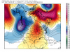 1 point
 -
I lost my keys in weenietown, once. I think it was back during one of those humid Septembers that we had.1 point
-
DEN hit 80 today! This is the second warmest November temp on record, and latest 80 degree day. But the north wind is finally blowing...already down to 49 and expecting a high in the upper 30s tomorrow with 1-2" possible by late tomorrow night.1 point
-
The first flakes of the year are flying now! Looks like a very intense band is approaching from the NW now.1 point
-
85 degrees in Coquille on February 9th of this year. This appears to have tied the highest reliably measured February temperature in Oregon, also 85 degrees at Coquille on 2/26/1992. Medford hit 79 on the 8th, which also tied the monthly record from February 25th & 26th in 1992. Even more remarkably, Tillamook hit 78 degrees on the 9th. This was higher than any previous temperature at TMK in either February or March with records back to 1948. The previous monthly record was 73 on 2/28/1968; the record for March is also 73 set in multiple years.1 point
-
Now for some post election humor from some of the locals around here (Steamboat ski resort), but very weather related: http://kdvr.com/2016/11/12/steamboat-protesters-more-snow-less-hate/1 point
-
I don't think he meant it was the warmest as far as averages. Just the warmest as far as potential for extremes.1 point


This leaderboard is set to Vancouver/GMT-07:00