
Leaderboard


.thumb.jpeg.e3014abf99ef08a9f9ac2c0cd31b485b.jpeg)

Popular Content
Showing content with the highest reputation on 11/03/18 in all areas
-
Funny all the talk of rain and I've not even noticed anything out of the ordinary. Maybe I'm a weirdo but i really never let the rain slow me down. I can work outside all day with the proper gear on and not even notice the wet. I'd rather have snow and cold anytime for sure over rain though.5 points
-
Here was the forecast for the 11/20/15 storm. That was fun.
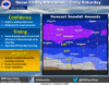 3 points
 -
3 points
-
For us older folks on the forum- how about the following song from Black Sabbath being our song for the upcoming winter? "Snowblind" released in the Fall of 1972 says it all for us winter freaks-- What you get and what you see Things that don't come easily (models vs reality) Feeling happy in my pain Icicles within my brain. Something blowing in my head (not enough sleep)Winds of ice that soon will spread Down to freeze my very soul Makes me happy, makes me cold My eyes are blind but I can see The snowflakes glisten on the tree The sun no longer sets me free I feel the snowflakes freezing me Let the winter sunshine on Let me feel the frost of dawn Build my dreams on flakes of snow Soon I’ll feel the chilling glow Don't you think I know what I'm doing Don't tell me that it's doing me wrong You're the one that's really the loser This is where I feel I belong Kiss the world with winter flowers Turn my days to frozen hour s Lying snowblind in the sun Will my ice age ever come?3 points
-
In your cold climate, it probably doesn’t matter. But it’s a bad thing if it gets too strong and screws areas that typically “score early” in +ENSO winters, like the PNW. Because it takes time time beat the vortex back once it goes steroidal.2 points
-
It’s early November. Despite the favorable pattern a lot of moving pieces need to align. We know how this game works. Getting overly excited for a snowstorm in early November more times than not will lead to disappointment.2 points
-
Every time you say Ontario I’m gonna take a shot2 points
-
It sure does. Pretty much holds serve from 00Z and none of this flip/flop nonsense shown by the GFS.2 points
-
12z Euro still has the snow-producing wave late in the week.2 points
-
The last time it has reached 60° or better here in Grand Rapids this year was on October 14th In October 1976 the last last 60 or better date here in Grand Rapids was on October 15th. November 1976 is one of only 9 Novembers in Grand Rapids history that it did not reach 60 or better. In 1976/77 October, November, December and January were all well below average temperature wise. While there was some lake effect snow on this side of the lake big snow storms were not the norm the winter season of 1976/772 points
-
@ Tom BTW, this question is for those older posters on here that can remember the late 70's. Was this a similar pattern that evolved in November back then?? It is still too early to try and compare past Novembers and remember no two seasons are 100% the same. But some past Novembers that somewhat compare to what happened this past October and to what could happen this November IMO are 1959, 1966, 1969, 1971, 1977. Of course there have been times in the past where November's weather did not carry over into the main part of the winter season. That said there is an old saying that "Ice on the pond that can hold the weight of a duck in November the winter will be filled with mud" BTW for winter storms my benchmark storms are 1967(January) 1973 (March) and 1978(January) Of the 3 the 1967 storm was the bigger one in Bay City. MI as we were living in town and were snowed in for 4 days. The 1973 storm Bay City had 20+ inches of snow and a flood as the NE winds pushed the Saginaw Bay on the shore of the bay and into the river into town. All 3 of the above storms had very strong NE winds, a lot of snow, and a lot of thunder and lightning. Think of a major summer time thunderstorm with high winds and down pours of snow instead of rain.2 points
-
My understanding today is that if you take the Euro's surface temps through day 16, you get only days 1-2 and 14-16 that resemble anything looking warm and I can tell you that day 15 is definitely not going to be close until all the craziness dies down. GEFS trend appears to be heading into the cold camp also. There's a few CONUS wide days there though that make every November I have seen look warm. Crazy. Happy November indeed!2 points
-
Hello Nebraska friends!! Looking snowy for you! Perfect spot to put a large ice blanket down for later.2 points
-
My friend, I cannot wait to read about this month as we go through it. It looks like the GFS is sorting out some November magic for me as we speak. I'm just tickled to death to be pretty much watching 3 months of words an prognostications, forecasts and patience actually be showing up for real. I'm excited for you and for all of us!2 points
-
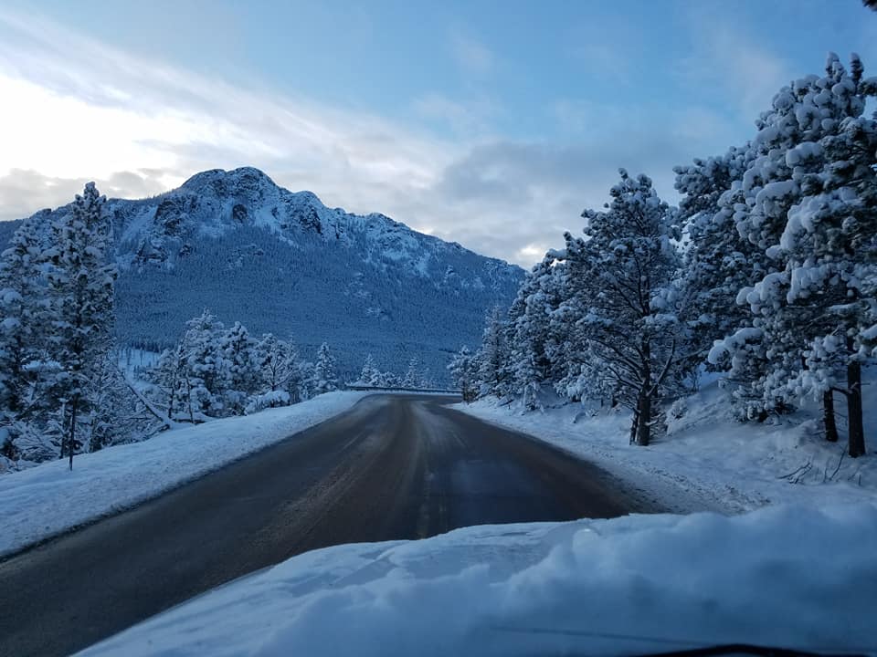
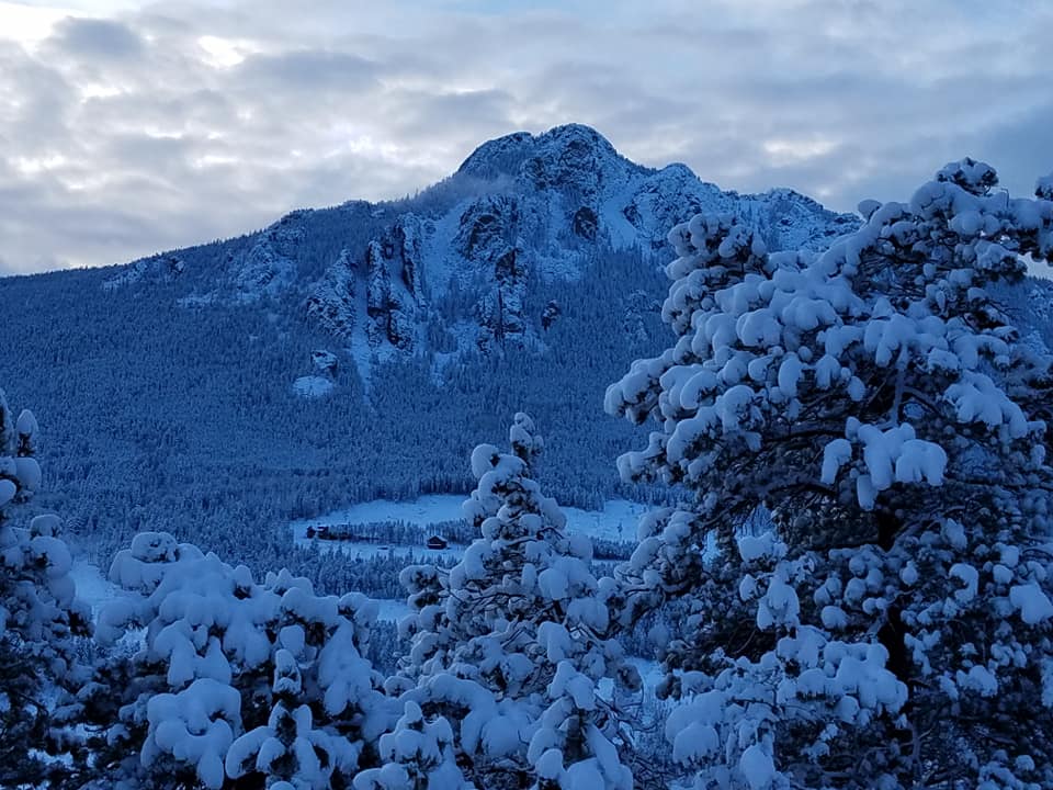
My commute to work this morning: The drive was a little icy. We got about 12" at work. View from the office: My cell phone doesn't take very good photos!
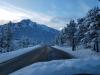
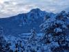
 2 points
 -
1968-69 was probably better in the PNW than any 1800s Nino that we have record of, although I've seen 1865-66 categorized as a Nino so I guess that one might top it.1 point
-
Or maybe an 18th century winter?1 point
-
Need some SSW event. Sounds breezy outside1 point
-
First and final call: a few wet snowflakes here on the backside of the low. Next.1 point
-
Where are/did you see that? If I looked out far enough, ofc I would have some. Did you mean this coming week, or when exactly? NWS local only mentioning a chance of mixed RN/SN later this coming week. No hype via GRR - guarantee u that amigo1 point
-
Tom, I don't think even an adult could've followed a "pattern" per se back then unless they were a Met or in Meteorology field somehow. Not sure you realize how much more data is available 40 yrs later. If I were just to go off of memory alone, I would say this November is shaping up to be cold like '76 but potentially much more snowy. '77 was a bit warm with snows hitting later in the month and then mostly NMI not really in SMI. Edit: Using data for KJXN as an example for SMI (mid-point across The Mitt) I see that while 11/76 was consistently colder than 11/77, so far we're starting out thru d3 colder than '76 did, at least for highs if not lows. Snow fell in both Nov's but all in the last week. '76 featured only 1" for the month, and '77 scored 3" so it wouldn't take much to best both of 'em in that dept. Even looked at 11/78 with it's 4" again in the final week of the month. The biggies appear to have been 11/66 with it's 13.5" total (9" depth on the 3rd!), and 11/51 with 9.5" total, again with the most during the first week of the month. So, I feel pretty good about my call that I could see the most impressive Nov of my (adult) lifetime since I was only 2 during Nov '66 and recollect zilcho, lol1 point
-
Had some vicious storms cross thru here last night. The NWS survey concluded it was an EF1 tornado and a downdraft with winds to 100mph. The smell of evergreen saturated the air all day today.1 point
-
Highly debatable.1 point
-
I say wait until tomorrow evening or Monday and see if changes on if you fire up a thread or just punt.1 point
-
Rain is wetter today.1 point
-
18Z GFS replaced a potent system with a 1030mb high and a bit of clipper snow for KS. Usually it's more gradual than that. GFS has been bad for the past month or two so I'm not putting all my emotions into it. It didn't show any snow falling for the October system until snow actually started falling.1 point
-
Yeah I'm not starting a thread. That was a piece of run.1 point
-
Jesus ******* Christ on a moldy, mossy cracker... You never ******* quit.1 point
-
Euro has trended towards GFS in terms of timing. I am worried about heights recovering in time to support a more Northerly track thru here. If 18Z GFS shows anyone with >6" I'm gonna pull the trigger on a thread.1 point
-
There's a much larger amount of posts full of sarcasm, attacks and complaints about Tim than Tim posts about rain. Food for thought.1 point
-
BAN TIM NOW! ROCK THE VOTE THIS TUESDAY!1 point
-
My god. Is this ever going to end? You're ruining this forum with this broken record garbage. That is all. Nothing more please about it.1 point
-
Forecasted high next Friday is 24 degrees, low 16. Whoa.1 point
-
If anything it has increased snow totals a bit!
 1 point
 -
Good preparation for what will likely be a ridgy late winter and spring given the ENSO state.1 point
-
PDX running 11.5 degrees above normal with -.20” precip for the first two days of November.1 point
-
We could use a few dry days up here for the ground to recover a bit.1 point
-
Just a little bitty mid November ridging on the GFS1 point
-
I’m assuming you are using the term “guess” fairly loosely, as the models are all on board for a drier and cooler pattern.1 point
-
Wind advisory posted for tonight for the puget sound1 point
-
Well hopefully it dose not rain on you because we all know how rare of an event rain is in November!! Lol.1 point
-
1 point
-
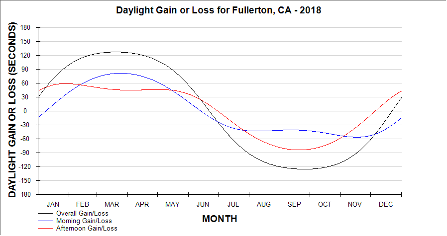
Today is one of only 4 days in the year where the amount of daylight gained or lost in the morning equal to that in the afternoon, no matter where you live.
 1 point
 -
The time change later tonight could not have been anymore "well-timed" than it is with all these potential wintry systems attacking our sub. Models coming in 1 hour earlier is gonna be so nice. Gosh I love this stuff! Meanwhile, the my trees are about 75% bare and today's weather is quite ideal for round #2 of raking before the next clipper system dives SE out of the Rockies and dig across the Plains/MW. Man, I'm really enjoying these systems all intensify smack dab in the middle of the nation. Even this little, "compact clipper" is going to produce a line of storms wrapping up into a healthy storm for the MW/GL's.1 point
-
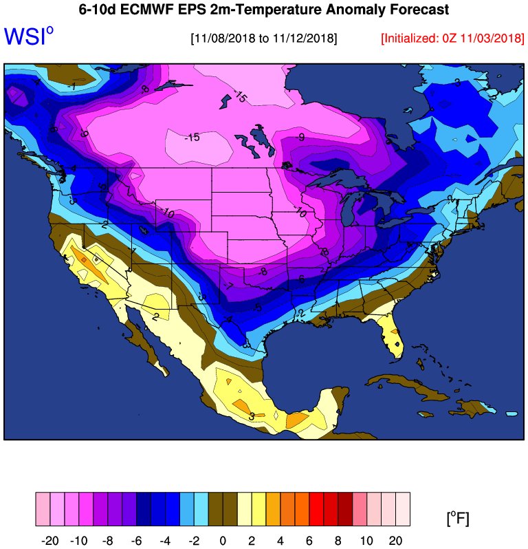
One of the more important aspects creating the environment to allow the cold to intensify this early in the season, will be what is about to happen in the higher levels of the atmosphere. 10mb temps near the Alaska/Arctic region are about -13C and in about 7-8 days, this region and near the Bearing Sea are going to rise dramatically towards +17/18C! That is more than a 30C flip in temps which will certainly play a big role. The location of the warming which is about to happen will put pressure on the Polar Vortex and elongate it like we saw in the recent cold winters of '13-'14 & '14/'15. Nature is aligning all the caveats early and often this season for what will be a magical season.1 point
-
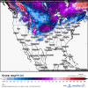
My mind is going bonkers realizing that we may be on the verge of a possible historic stretch of weather during the opening 2 weeks of November. All the modeling are seemingly heading towards a ferocious start to winter, one that not only includes the cold, but systems galore! My goodness, I don't know where to begin. It's like we snapped into winter 1 month in advance when just over a week ago the models (except for the Euro/EPS) had been showing a benign pattern with some cold. IMO, this is likely going to be a trend this year and we can be rest assured that the models may be underestimating the magnitude of the cold this season and suppression/blocking should def be impactful. All I'm saying for now, is enjoy this stretch bc what I think is about to happen, memories will be made for many of us...at least for me, even if I'm not in the direct hit from a snow storm. Instead of us all watching the East Coast peeps get buried time and time again, they will have to sit on the sidelines and watch the "Central CONUS Show"...haha, I like the sound of that!\ So here we are, have you seen an EPS snow mean like this on 11/3??? The ensembles are picking up on yet another "cutter" around Veterans Day....this is an astounding hyper-active pattern we are entering. #mindblown BTW, this question is for those older posters on here that can remember the late 70's. Was this a similar pattern that evolved in November back then??1 point
-
Even though this system doesn't look like it will produce much wintry precip, I'm still very interested where this storm tracks, intensifies, begins going neg tilt, how the models handle the blocking, etc as we continue to figure out this overwhelmingly exciting pattern. FWIW, the 00z EPS ticked SE and now the model is taking the mean SLP track thru S IL/C IN/S MI.1 point
-
It's all a while away. I'm not getting excited about anything yet. One issue with the lastest GFS run is it sharply weakens the Friday storm. That storm 9 days out is a beast, but alas, it is 9 days out.1 point
-
Yeah, you want slower if you're north. Not too slow though because then the northern stream could end up squashing it.1 point
-
This front has been really impressive for mid October! Down to 26F with 20+ mph north winds and a current wind chill reading of 12F. http://i68.tinypic.com/2a7x4ee.jpg1 point


This leaderboard is set to Vancouver/GMT-07:00