
Leaderboard


Popular Content
Showing content with the highest reputation on 10/20/23 in all areas
-
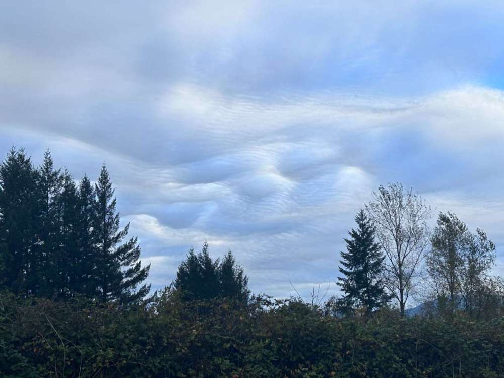
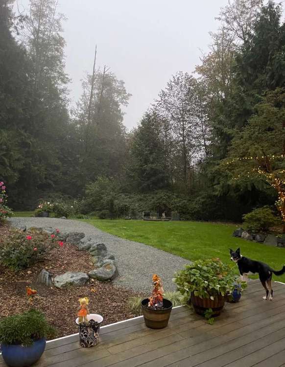
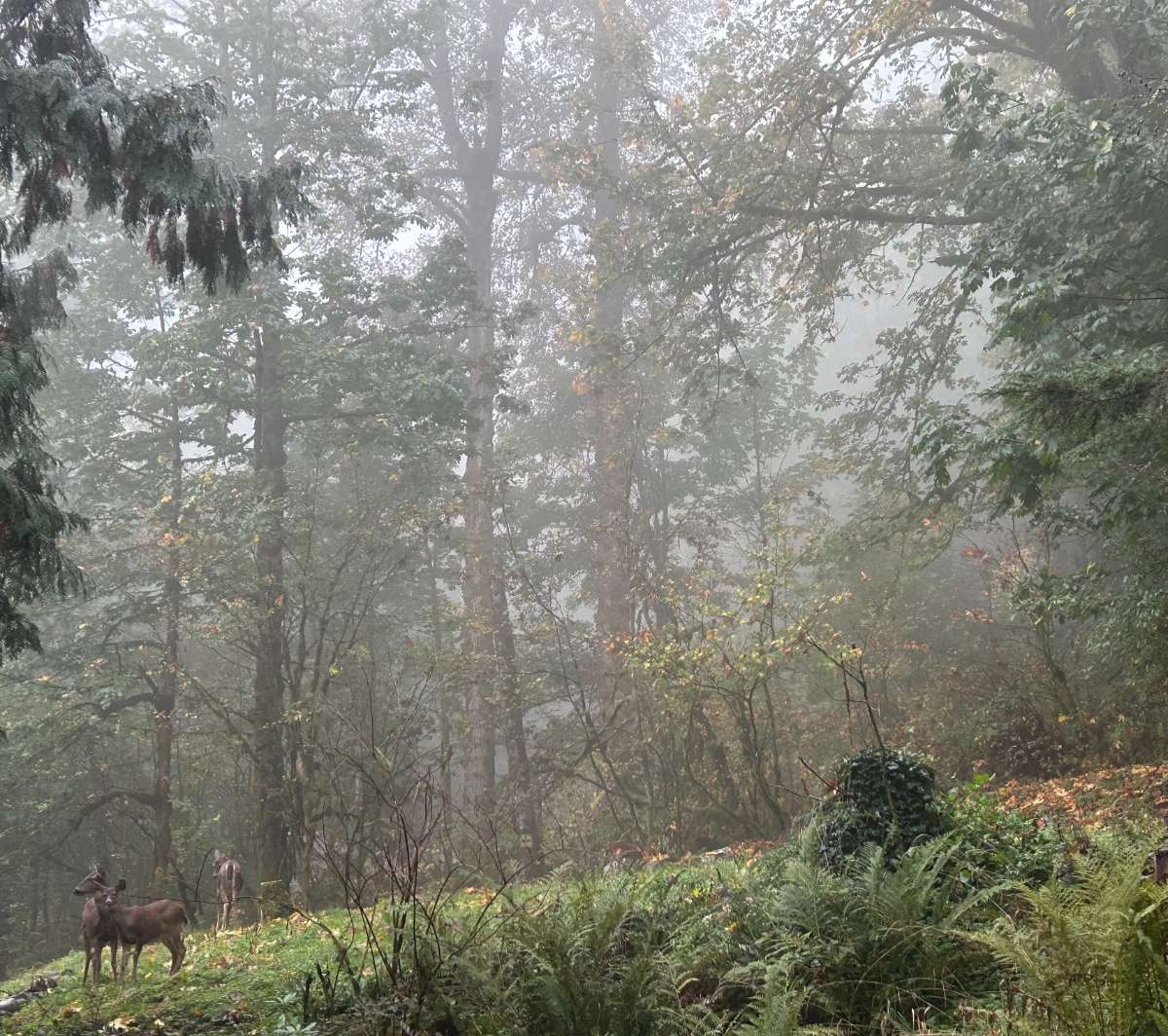
Eye-catching clouds on the drive home yesterday seen over the middle fork. Completely socked-in this morning at home, really feels like Fall. 1.62" of rain for the week, 4.61" for the month.

 14 points
 -
I have more snow today 20231020_110529.mp47 points
-
It would be pretty hard to do in this era but I bet you could learn a ton from just watching the clouds and a personal weather station and trying to guess what is going to happen. I love going on a backpacking trip or somewhere off the grid and having to make my own weather forecast. I've experienced a couple of surprise snowfalls and they were some of my favorite weather experiences ever. I followed the weather for as long as I can remember and was always aware of the forecast, but it was easier for surprises to slip through the cracks back before I understood how to look at weather models, NWS forecast discussions, etc. Once when I was maybe ~12 I woke up and looked out the window and there was a fresh coat of like 3-4" of snow on everything that was completely unexpected (at least based on the local news forecast the night before). I'll never forget that feeling of looking out the window and seeing that. The more recent one that happened was around 2006-ish in Madison WI in mid-October. There was a fairly potent cold front coming through with strong winds and rain but the forecast was confidently for all rain (it was mid-October after all). I went to a movie with my girlfriend that evening and it was raining and 45ish when we went in, two hours later we came out of the movie and there was a coat of 2-3" of snow everywhere. It was such a shock. In that group of people from the movie there were two people visiting from Texas who basically turned into children when they saw the snow and they were with some locals who were total grumps about the snow ("...see what you think of snow when you have to deal with 6 months of it..."). I know we've had surprise flakes in Seattle but it would take something really extraordinary to get a surprise couple inches that slipped past those of us that carefully monitor the forecasts.6 points
-
Monday sure turned into a fun weather day. Extremely heavy rainfall at points that afternoon, and the minor tornado in central Vancouver. Ended up with a 66/51 spread that day. Evening low. Picked up close to an inch of rainfall with the morning stratiform rain and the afternoon downpours. Tuesday was partly to mostly cloudy with some spots of morning fog. Weak warm front lifted north across the area late in the afternoon with some sprinkles. 64/47. Wednesday started chilly and foggy, but was warm and sunny by afternoon. 71/42 spread. Yesterday started out cool and foggy as well, but rose to the low 70s in the afternoon with a light east wind. 72/44 spread. Mild morning today with more low clouds than ground fog. Low of 52 but that was early last night before the clouds formed. 55 currently. Would be nice to have a chilly last 1/3 of the month but the models still haven’t made up their minds.6 points
-
Great weekend to get outside in my area. Mid 70s to and tomorrow and 70 on Sunday.5 points
-
Not to be a Negative Nellie, but I don't have confidence in any of the global model solutions so far. For example, latest GEM (12z) has only around 0.30" QPF for me over the next seven days. That's not gonna cut it. I keep thinking of the old adage "never forecast rain in a drought". Still, plenty of time for more twists and turns...5 points
-
For those of you who are interested in understanding the LRC here is a snap shot. This was from back in 2018-2019, I took a screen shot of the storm system that affected us in Oct of that year. The other image is when the bomb cyclone hit my area that March. Pretty remarkable how the systems not only resemble each other; the storm almost hit on the same exact date 5 months later!
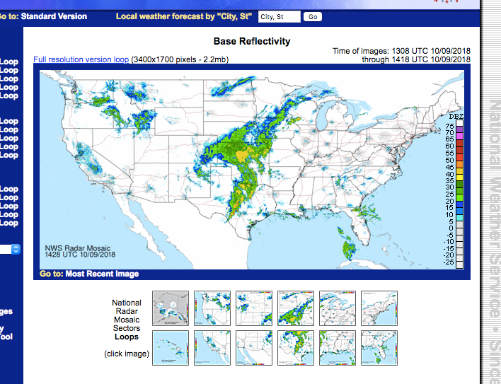
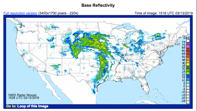 5 points
 -
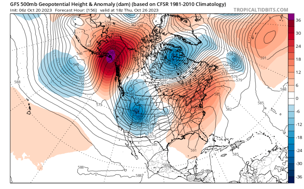
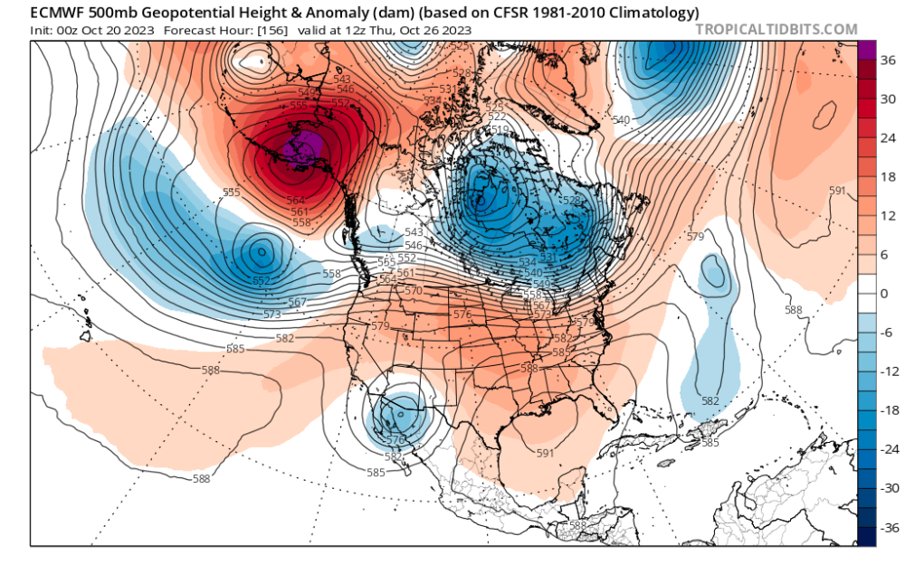
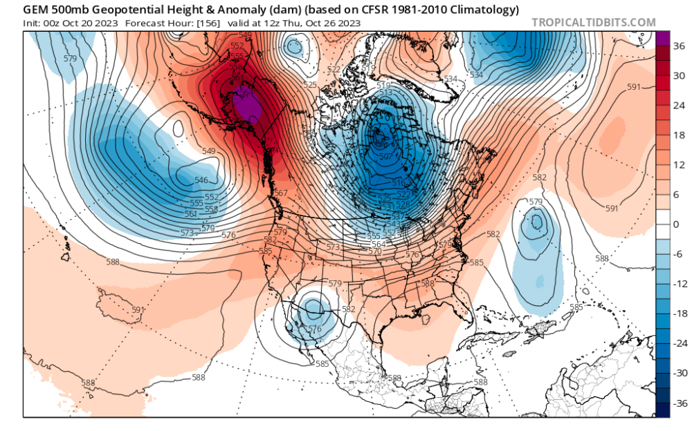
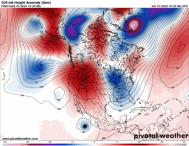
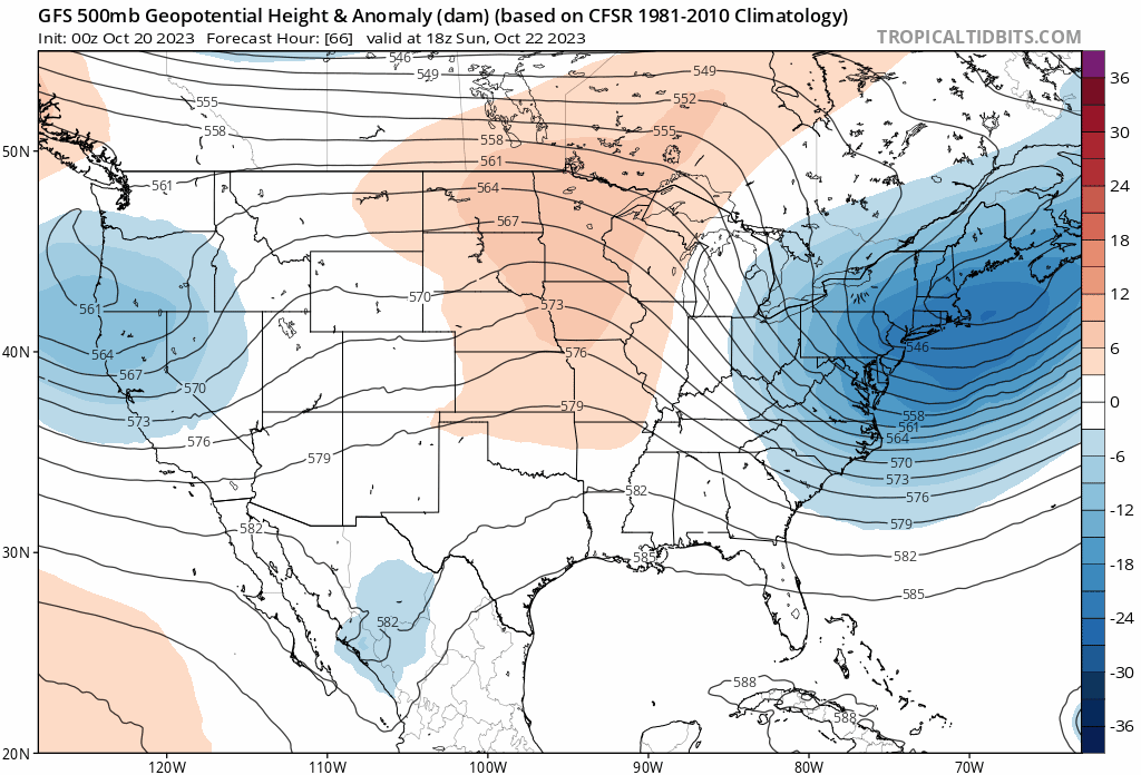
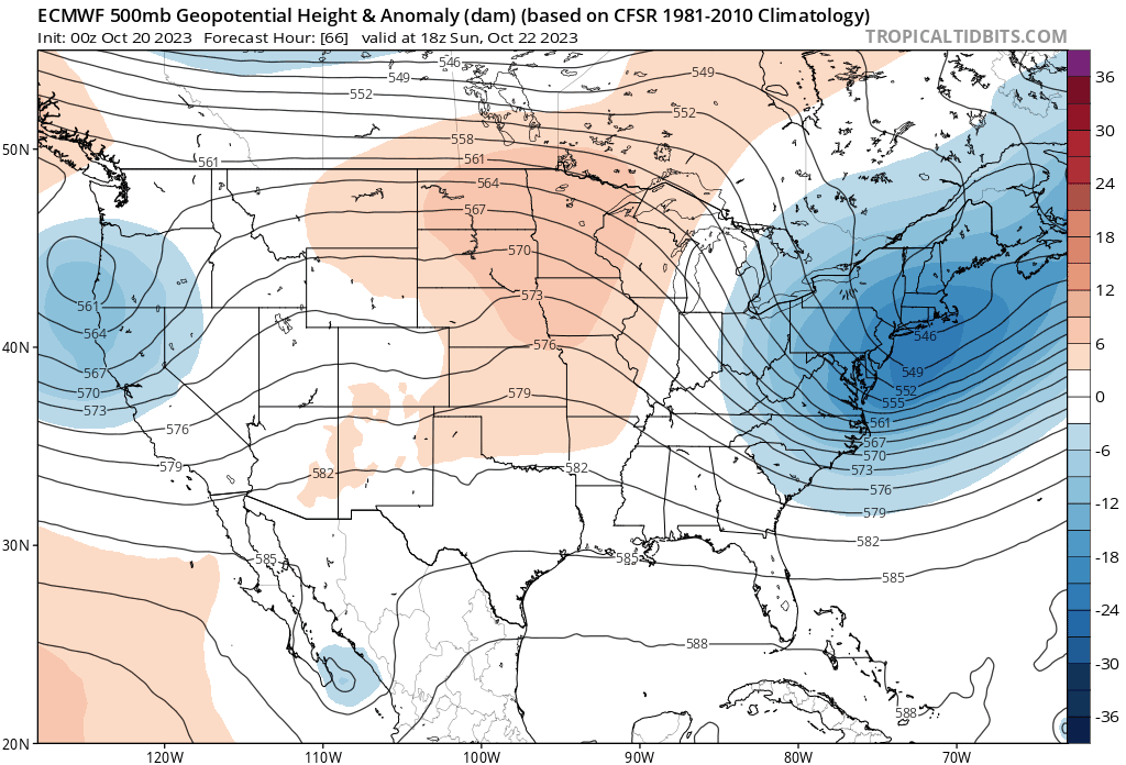
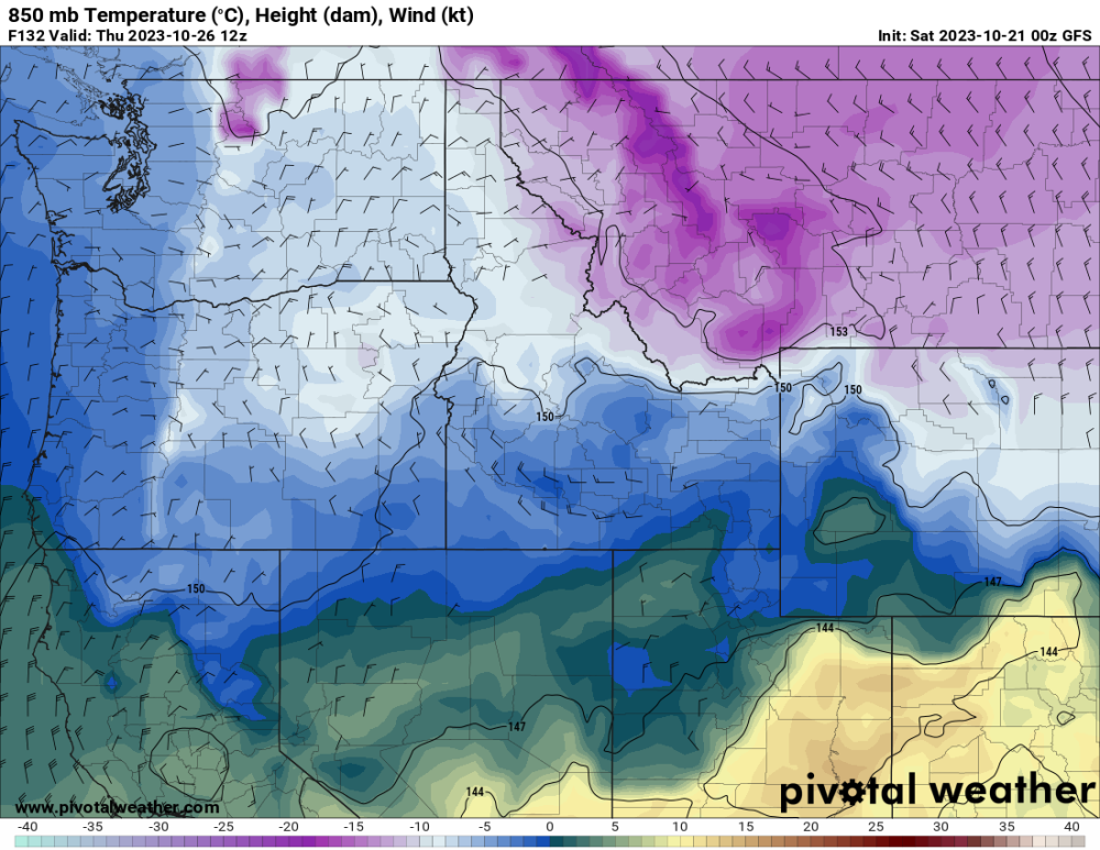
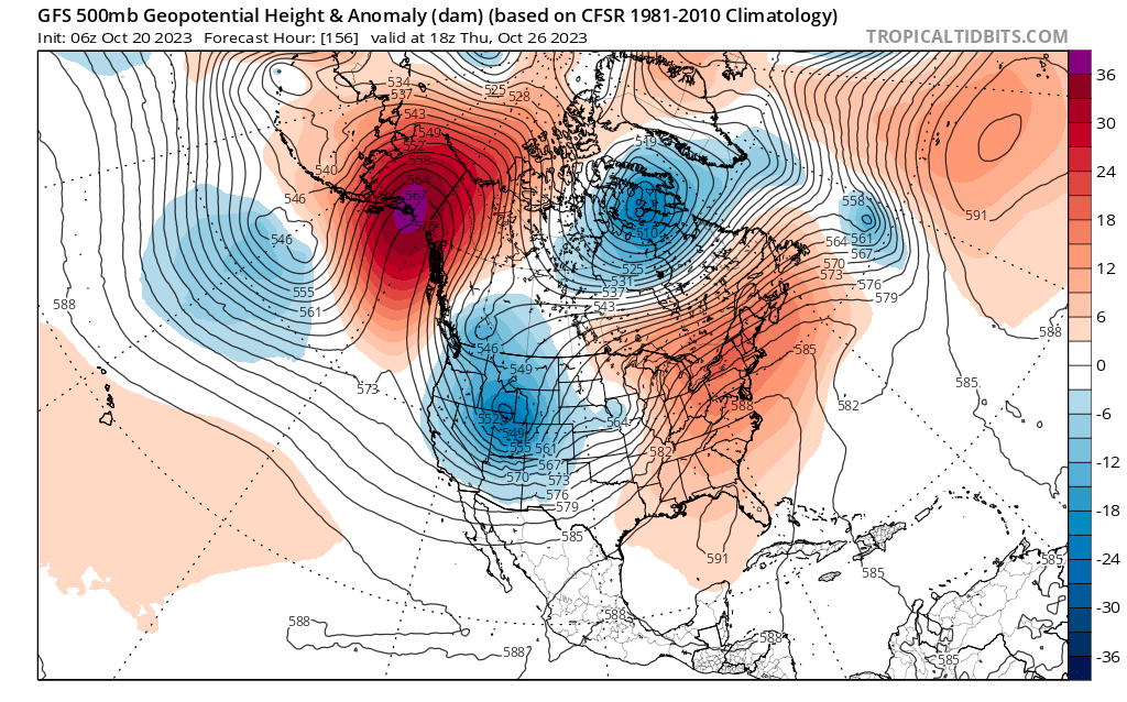
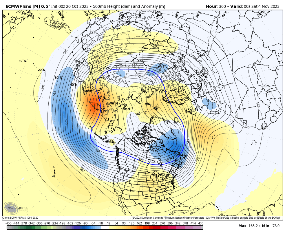
Really hope the GFS ends up right with how it phases all three pieces of energy together next week. Makes it much more interesting than the Euro/Canadian solution of keeping everything separate. There are extremely large differences in the 500mb pattern just six days out (maps below). I have a feeling the Euro solution will end up correct just based on it's overall better accuracy. But the GFS could still pull out the surprise and end up winning this battle. It will be interesting to see where the models stand by the end of the weekend. By then, the pieces will be starting to move into place within the upper level pattern. That should allow the models to start getting a better initialization and by extension, a better handle on how things will ultimately play out.
 5 points
 -
Thanks for firing up the thread Clinton! It's finally exciting to see a long duration SW Flow pattern that will pretty much encompass our entire Sub Forum. Been waiting for this week of weather to see how it would evolve. The models are still not quite on board as you mentioned there are many variables at play here. I'd like to see 1 or 2 wound up storms out of this pattern for the central CONUS. The teleconnections appear to signal a decent chance to wind up a storm but the DEEP -EPO is always a culprit for a storm to get cutoff in the SW. Look at that "Omega Block" near Alaska...this new LRC pattern setting up is going to be a year well known for the year of Omega Blocks. We've had several instances already of these atmospheric phenomenon's setting up across various locations across North America.
 5 points
 -
Jim @snow_wizard would love this run!4 points
-
I feel like mother nature needs to treat us nicely on this one and get us some good rainfall. I would hate to be 0-2 in the new pattern, GFS and GEFS both looking pretty good this afternoon. However I do have the same skepticism when it comes to drought. Mother Nature will have to show me!4 points
-
That PA announcement translated said “Haha Pacific Northwest United States, we have already kicked your ass in the snow department”4 points
-
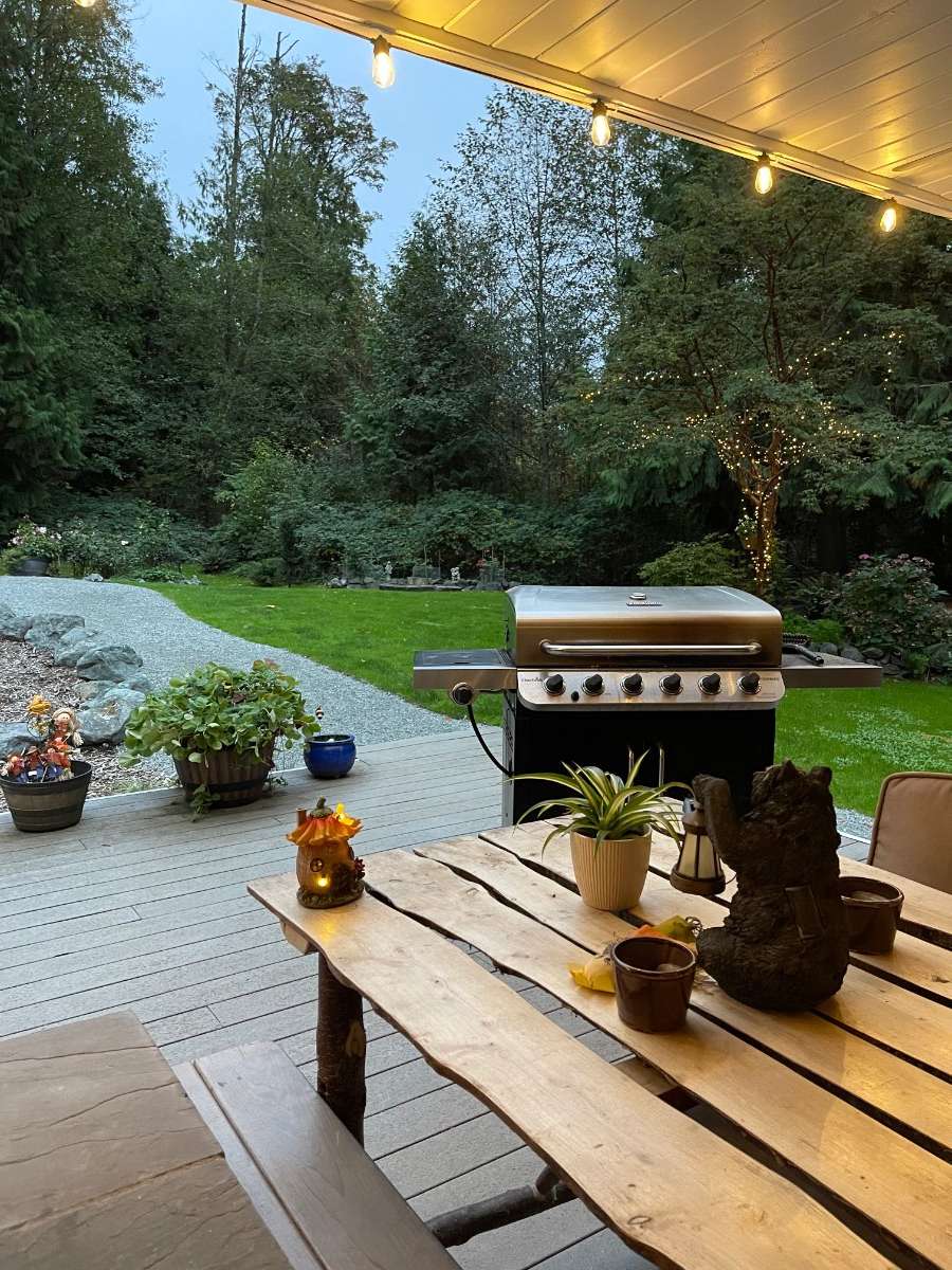
Lovely evening to BBQ on this late October 63 degree evening. I need to mow again.
 4 points
 -
The EC has never been fully in or out on westside cold, it was like 3/4 of the way to saying yes two days ago and now it’s 3/4 of the way to saying no. Could head back the other way again. Better odds east obviously. Personally I kind of hate getting a block this time of year, I would much rather prefer an active Pacific storm train and be tracking potential windstorms right now. Without true arctic air these Alaska block patterns are pretty boring in terms of actual weather. If it snows down to the top of Tiger Mountain next weekend I’ll go try and see it but even that seems unlikely.3 points
-
Weak @$$ Arctic trough... Saving the good stuff for later3 points
-
I can see Russia from my house.3 points
-
The reason for the widening model differences is how each handles the northeast Pacific. The models (mostly just the GFS now) that dig the second trough into the west have a Gulf of Alaska ridge that separates the diving sw Canada energy from a big system out in the Pacific. What more models are trending to now, though, is the ridge gets pinched off, so the diving sw Canada energy and the Pacific energy connect and interact. This interaction prevents the sw Canada energy from digging further.
.thumb.gif.ea7175e128be935fcaa41b2a6a846851.gif) 3 points
3 points -
Any of yall thought about going into a winter completely blind? No models, no forecasts, no radar, no nothin' I could never because I'd miss out on the four mixed snowflakes in the rain at 3:30am, which constitutes 90% of our observable snowfall.3 points
-
I read that the Europeans have given up and are de-commissioning the ECMWF and EPS. Performance is always at the bottom and way below all of the models.3 points
-
I'm not liking the trend of some of the models. The GFS suddenly lost the western trough (the one behind the southwest cutoff) a couple days ago, but it is back now. However, the Canadian has no trough at all over the west, instead showing a fast wnw flow over the northern US, which does not allow the southwest cutoff low to lift northeast and totally screws the big rain event around here. Unfortunately, the UK has now also shifted from a western trough to garbage, just like the Canadian. Last night's Euro showed a hint of this as well, but did not go all the way. It's quite possible the big event could vanish.3 points
-
PHX set another record high yesterday of 104F...we'll prob match that today and likely set another record! It's just nuts to even fathom that its this Hot in late October. Normal high today is 88F....changes are coming and the Valley is ready for this Big change towards Autumn weather. Its been nothing short (pun intended) of wearing shorts and T's around these parts. As much as I'm a fan of Summer wx, I'd like to also see the snow begin to fall in the mountains up north.3 points
-
00z GFS
 3 points
 -
Blizzard of 1996 in NYC was on my mind today..not sure why, maybe because we are heading into winter eventually I guess...but man, I wish I can turn back time and relive that storm. Such a massive blizzard!!! It began snowing Saturday morning at 7:00am and it just kept snowing very heavy w/ winds of 50-70mph continuously for 37 Hours straight. In northern Queens where I lived at that time, I received near 30" and could not even see the cars on the street w/ drifts as high as 8Ft. Temps throughout the storm were frigid. Mainly in the low teens and at night they dropped in the single digits w severe blizzard conditions. The whole area was a standstill. I don't think I will ever see a storm of this magnitude ever again. Here..are some incredible pics:3 points
-
Todays 12z models show the pattern reloading with storms behind next weeks system. With some cold air in place, some of the northern and maybe central posters could see their first snow of the season. Spooky Halloween!3 points
-
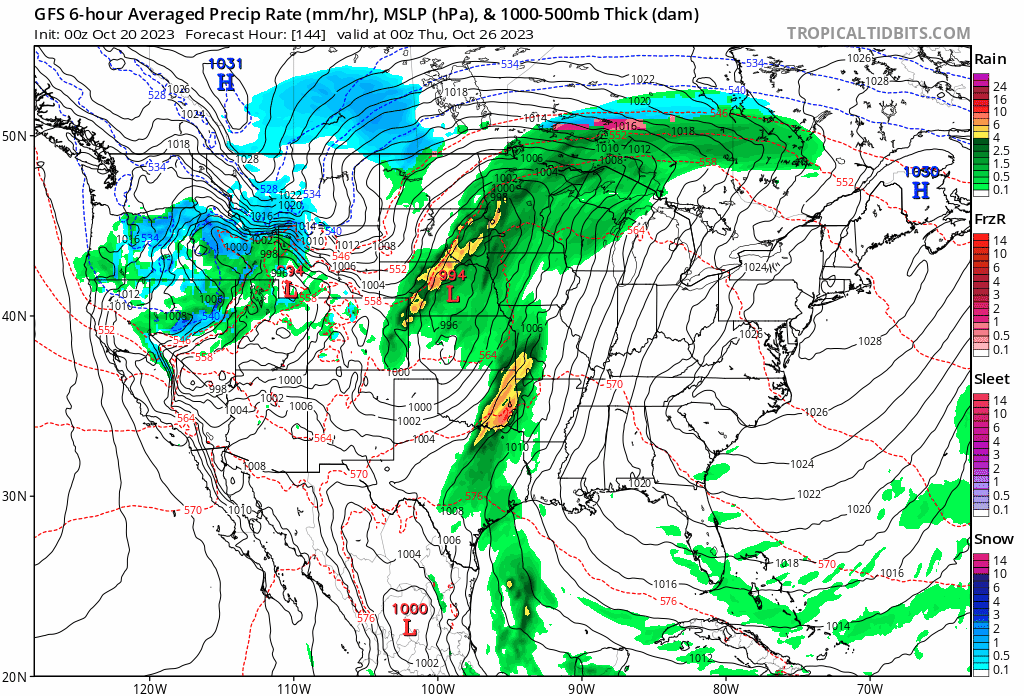
Looks like the middle of the country could enjoy a good soaker and could the northern plains enjoy their first snowfall? Lots of questions ahead to see if any of the energy coming out of the SW can phase with hurricane Norma as the remnants potentially move into the central US. The GFS shows the energy phasing as a storm system rounds a deep western trough. The Euro keeps Norma and it energy kinda staled of the Mexico coast however both models still deliver nice rains. GFS Euro Finally a 3rd piece of energy will dive in from the Pacific NW bringing massive temperature change and our first taste of Winter. This could lead to the first significant snowstorm of the season for the Dakotas and Minn and more rains for the drought stricken areas in the plains . Could the snow make it further south, lots of time to figure that out as models digest what looks to be an exciting week of the new LRC. Total precip: GFS Euros take Ensemble Means The Wintery side:
 2 points
 -
I won't be here for the 00z Euro. Pretty good GFS Op run. Hopefully the GEFS is in decent agreement, and of course we always seem to heavily weigh the 00z EC and EPS above all.2 points
-
If this were a month from now I would have already peed a little.2 points
-
Day 5.5 850s. That's pretty dang impressive
 2 points
 -
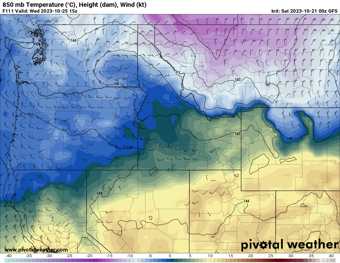
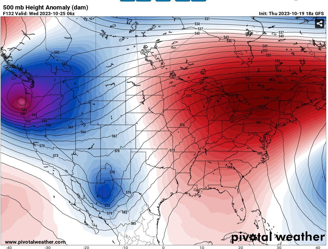
Before Day 5 and cold air is sneaking back into northeastern Washington.
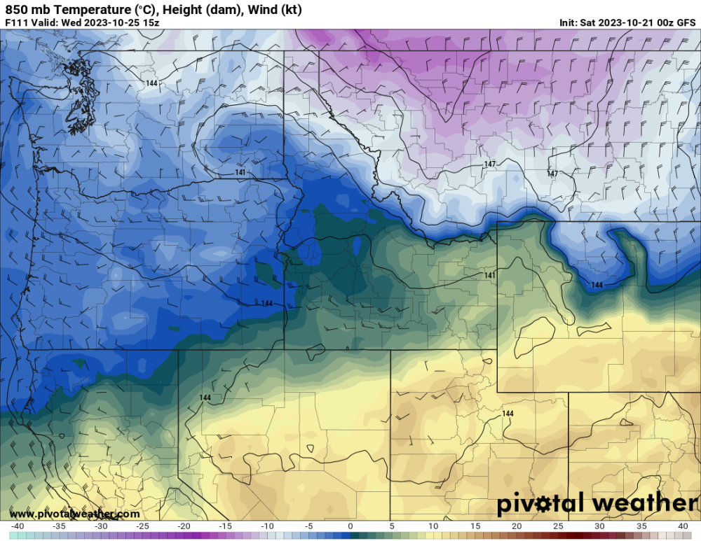 2 points
 -
Very well put.2 points
-
10 degrees cooler for night two of BBQ’ing. 53 currently! Sound up! IMG_9560.mov2 points
-
The ICON was the only model in the GFS camp and its 18z run made a pretty big jump towards the ECMWF solution. Would be hilarious if the GFS scored a once-in-a-blue-moon coup but I’d put my money on the Euro/EPS.2 points
-
That period of uncertainty next week stands out like a sore thumb. Same standard deviations as the end of the run.2 points
-
Wish this GFS run had been the Euro.2 points
-
A reasonable answer. And it seems young adults are getting sucked into the "look at everything Israel did and ignore the fact there are currently hostages." I'm rather disappointed in some on the left being irresponsible with their words. I can't be hypocritical. If any of you weirdos got abducted by Canada, I'd sure as hell want my country to do what it takes to bring you home.2 points
-
53 and drizzzzzle!
 2 points
 -
I remember that really well. We had halloween canceled that year I was so mad! We had that really cold stretch at the end of Oct. into Nov. but then after that the rest of the winter was a blow torch. I think it was like 70 on x mas that year.2 points
-
I agree and on the heels of next week's storms the pattern looks ripe for another one to dig in with some cold air in place. Both the GFS and Euro have been hinting at that as looks to reload quickly.2 points
-
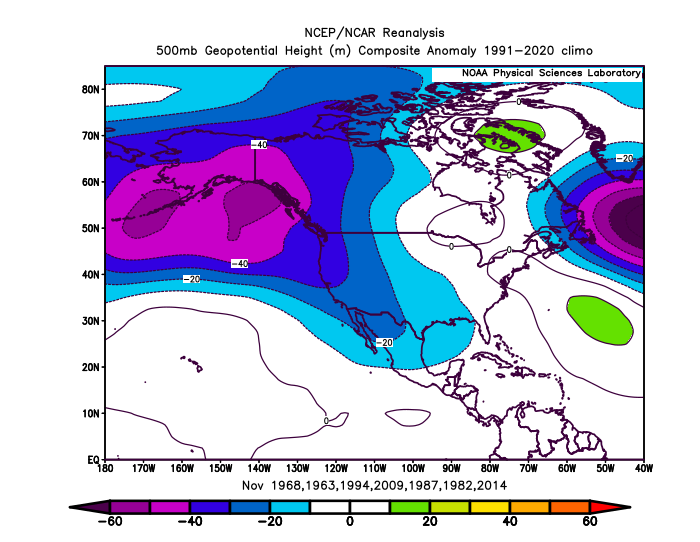
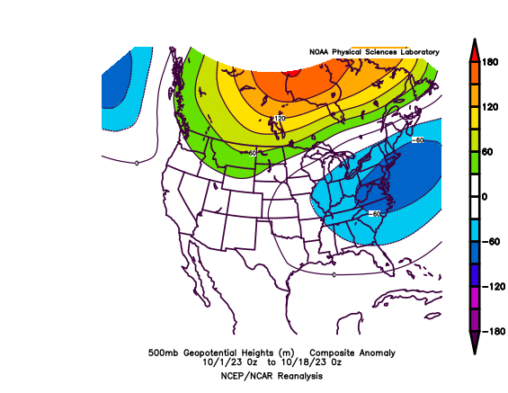
Here is an updated look at how we are doing for 500 hPa height anomalies for the month. Here is the model forecast to close out the month: In terms of the final anomaly pattern, it looks like we will mostly maintain the anomaly pattern, but it'll be weaker for the ridge area in Canada and stronger for the ridge area in the SW USA. But we also are seeing some important changes happening. We've had pretty substantial ridging across Canada for much of the last 5 months or so, and that is finally done for now if the ensembles are to be believed. It looks like a trough on average will sit over eastern Canada. Also, notice the ridging north of Hawaii and troughing north of that. This pattern is also a change, and should raise the PDO as long as it lasts. But what caught my eye on that last image is how closely it matches the analog forecast for December I made earlier this month: It's not perfect, but it's not bad. It also looks like more classic fall Nino forcing.

 2 points
 -
October now has 19 days in the record books. At Grand Rapids, MI the mean is 54.8 that is +1.1. The highest for the month was 86 on the 3rd the coldest low so far is 37 on the 8th There has been a total of 3.86” of precipitation that is +1.40 for the 1st 19 days of the month. There has been no snowfall yet. There have been 2 clear days 11 partly cloudy days and 2 cloudy days so far.2 points
-
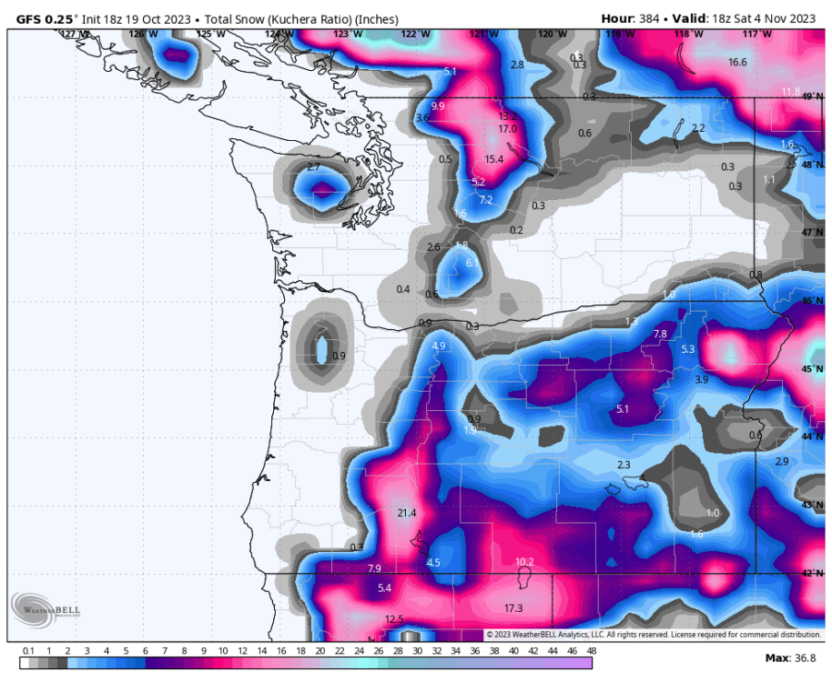
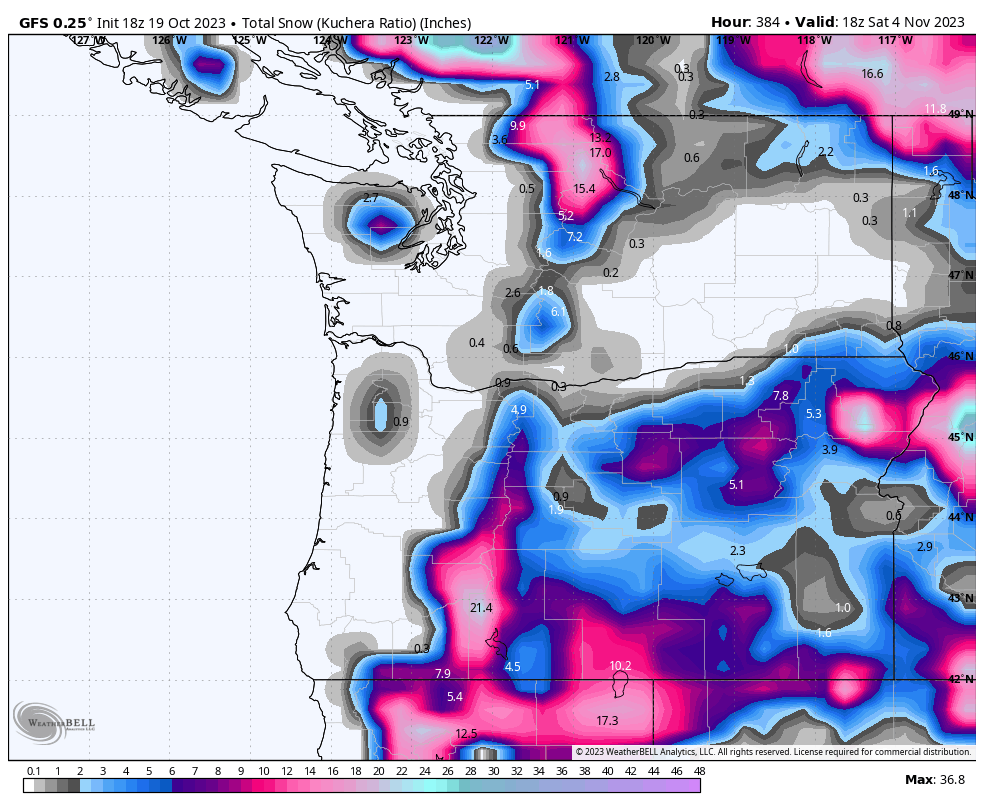
Snow totals on the GFS
 2 points
 -
To put it mildly. Average yearly snowfall in Monument is 110.6" https://en.wikipedia.org/wiki/Monument,_Colorado#Climate2 points
-
Would bring back memories of the Halloween Blizzard of 1991. I would say that is a top 5 in the best blizzards that I’ve lived through in Central Nebraska. Not calling for a blizzard, just remember the record cold of late October into November 1991.2 points
-
I'm digging the heavy rain circle. It's been dry for so long, I feel like I have a lot riding on next weeks system or systems just to convince me next year wont be like this past year.2 points
-
A month later this would be exciting.2 points
-
2 points
-
It hasn't even been three full days since this thread started and personal insults are already flying, reports are already coming in. Similar to the abortion issue, this is a passionate topic that can get very ugly very quickly. If it continues down this road, I will close this thread and more forcefully stop this topic from being discussed in the politics thread. Enough is enough.1 point
-
So 38˚F rain it is for you, then!1 point
-
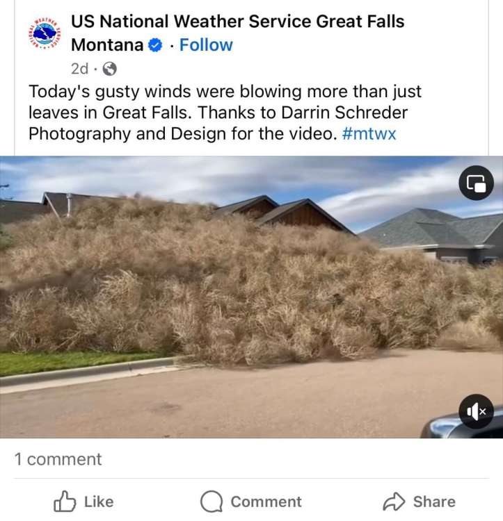
Quite the drifts! Anyone up for doing some tumbleweed angels?
 1 point
 -
I think you sometimes get hung up too much on semantics/chicken-egg with this. Yes, the PDO is a reflection of other external forces. But that doesn't mean that what the PDO is representing is not influential and to an extent predictive.1 point


.gif.86e918ace4880fc95c0aff9b8423f712.gif)


This leaderboard is set to Vancouver/GMT-07:00