
Leaderboard


Popular Content
Showing content with the highest reputation on 10/24/21 in all areas
-
Dark cell just to my south with blue sky following up. Winds blowing hard!
 15 points
 -
Just in time for the squall line! Excited
 12 points
 -
Lol was awoken by what sounded like branches clanging together about 30 minutes ago probably 75 feet from my tent…was scared sh*tless since I had no idea what the sounds were. Came out of my tent with a knife ready to get in my car since I wasn’t sure if it was a person doing it and I point my my flashlight and see these big a** bucks beating on eachother with their antlers. Makes sense now! So I scolded them and they ran off lmao.12 points
-
Had a 50mph wind gust and 1/2inch of rain, but it's all over now and the sun is shining. Storm total for this one was 1.25 inches. On to the next one.8 points
-
I freaked myself out while camping in the back of my truck in Alaska...swear I heard breathing right by me, in my head,it was a huge grizzly...turns out it was ME moving on the air mattress. That was at 3 in the morning, could not get back to bed with my heart racing still haha7 points
-
She’s a beaut Clark!
 7 points
 -
You have really matured on here quickly, well said!!7 points
-
There was a Tornado Warning at 2 today for a confirmed tornado about 5 miles west of my place in Troy Kansas. The cell passed about 1 mile north of me but I'm pretty sure the tornado lifted shortly after forming. Went outside when it passed and it felt like May outside. Now it's misting and feels like November. What a storm system. Crazy October weather. I sure hope this stuff comes around in December and we can get a blizzard out of it6 points
-
Already at 1.9” of rain with lots more coming. Temps have been in the mid 40s with lots of thunder and lightning6 points
-
Jim is not a fan of the wind… I would venture to guess that if that was a massive snow bomb off the coast he would be looking at the Yugoslavian model that shows the storm getting close to us and he would be all over it!! And we are going to need his snow/cold enthusiasm here in a few Weeks!!!6 points
-
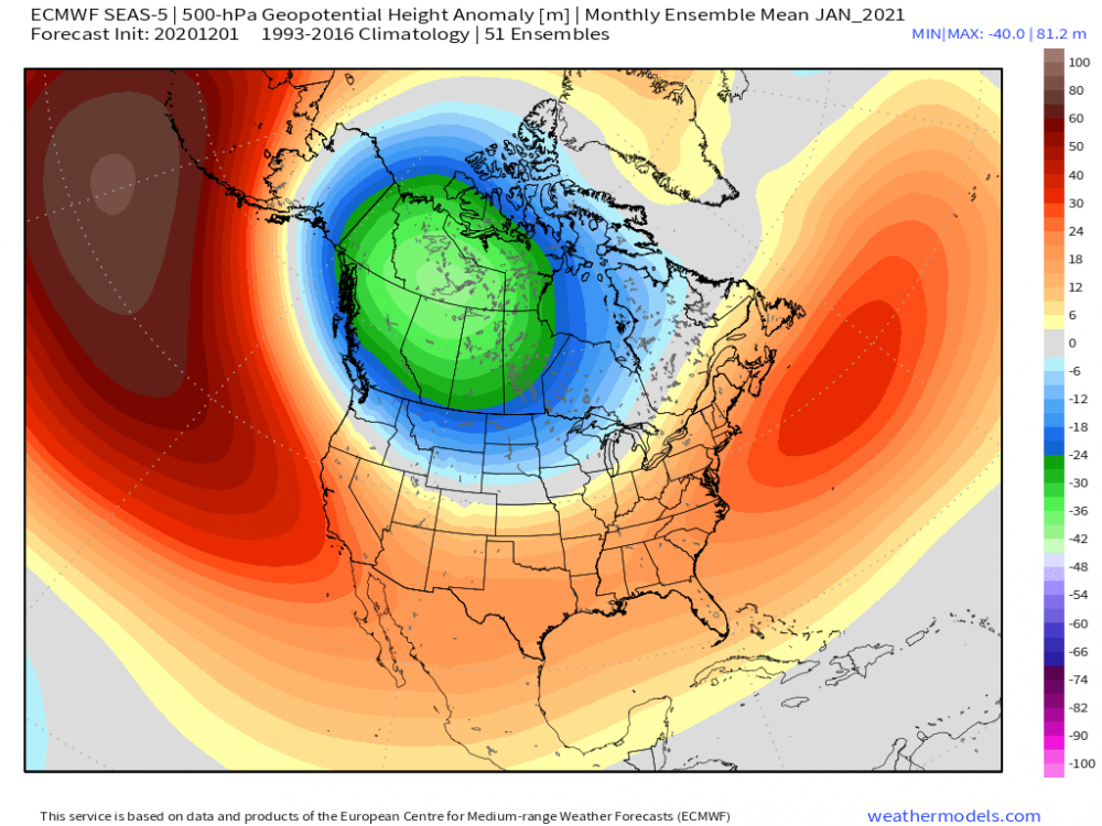
Pretty interesting video from Jim Flowers regarding the new pattern. Talking about a cold Nov/Dec https://www.facebook.com/148018328718825/posts/1846651418855499/5 points
-
Downtown Sacramento with 4.31" of rain so far today, breaks the record of 1.21" set back in... 2010.5 points
-
We've had rain on 8 straight days now. 13 of the past 15. We should run the streak to about 12 days it looks like.5 points
-
Just crunched a few #'s on Warm/wet Octobers and see if there is any correlation to the following winters. I could find no years that matched with back-back to La Nina (however the 1880's are not listed in my Nina data) I used an avg mean temp for OCT of 53.8F which is the avg of 142 years at DSM #1- 47-48" OCT precip- 6.86" (3rd wettest) Avg OCT temp 62.4 +8.6 compared to 142 year mean (2nd warmest record) Seasonal Snowfall 29.8" #2- 2007-08 OCT precip- 5.49 (9th wettest) Avg OCT temp 57.2 +3.4 Seasonal Snowfall 58.5" (snowiest FEB at the time) #3 1882-83 OCT precip 5.94" (7th wettest) Avg OCT temp 56.1 +2.3 Seasonal Snowfall MISSING. But a very cold JAN/FEB Take it for what's its' worth. All three winters were below avg in temps.5 points
-
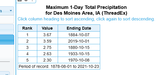
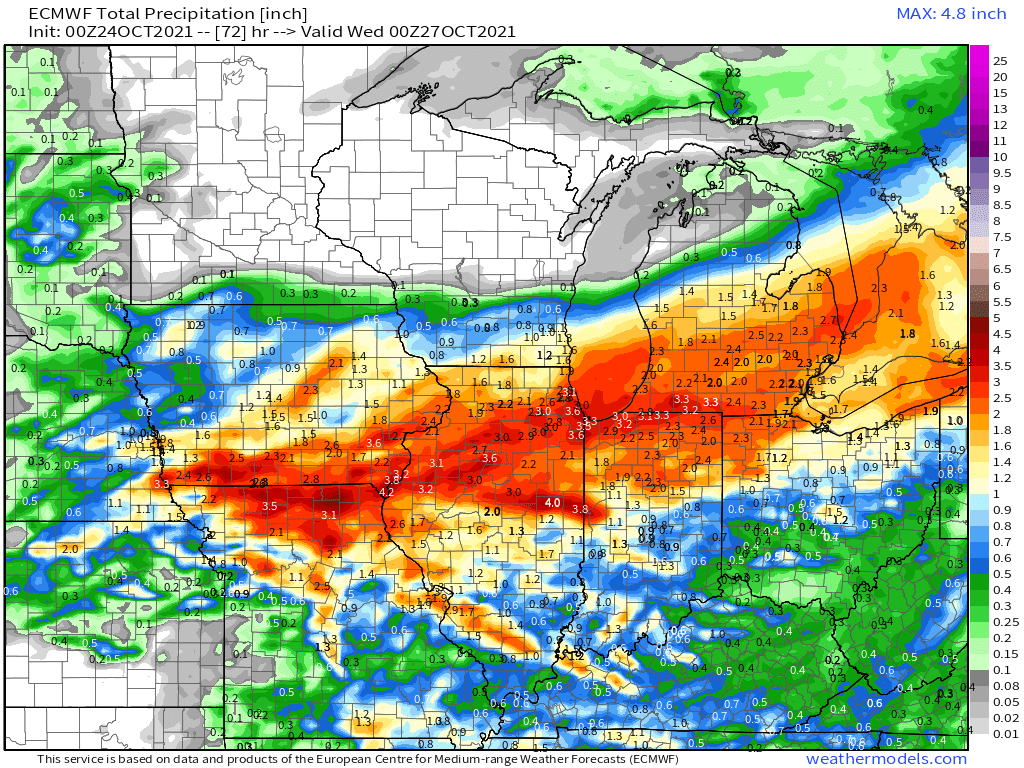
nearing 2.6" at KDSM and at mby 20 mins W of town. Easily going to reach 3" as it .25"+ hour rates that look last at least several more hours. Add in an expected 1-2" later in week and the precip deficit that was 11" + entering OCT will have been cut in half. Daily record set for the day and easily will reach the 3rd wettest OCT daY on record. I will dig into wettest 4-5 day stretch if the mid week system drops what it looks like it will.
 5 points
 -
Just a wild day of weather. Glad most of the forum got in on this. Currently have heavy ran, lightning, gusts to 30mph and 47 degrees5 points
-
Strong line of storms about 20 min to my west. Looks like they're about to go severe.5 points
-
My gauge has almost an inch now and there's plenty more on the way... about 12 hours worth. Man, I'd love to bottle this system and bring it out again in December or January.5 points
-
We’ve got a root cellar on my family’s property that stays dry and somewhat warm since it’s into the side of a hill…got a wood stove inside too so there’s atleast somewhere to shelter if it gets too sh*tty.
 5 points
 -
Tom buddy, you read my mind. Over night I was thinking about Niko's comment that this would be a 1-2 footer around Detroit (which is rare air historically speaking). Then I thought, wait a minute, they actually did get that size of storm (now #3 all time) with GHD-2's 16.7" total. I was like "oh, this would be GHD-2 with winds from the bliz of '99". Boom! Great minds arrive at the same point. EDIT: Like how "later forecasts may increase wind gusts"!5 points
-
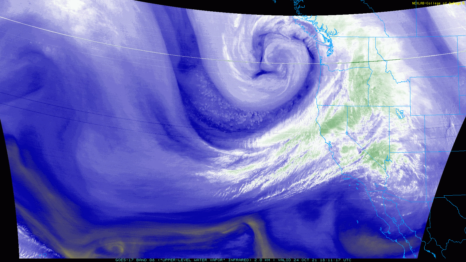
Looks tasty out there. https://www.star.nesdis.noaa.gov/GOES/sector_band.php?sat=G17§or=np&band=GEOCOLOR&length=12
 5 points
 -
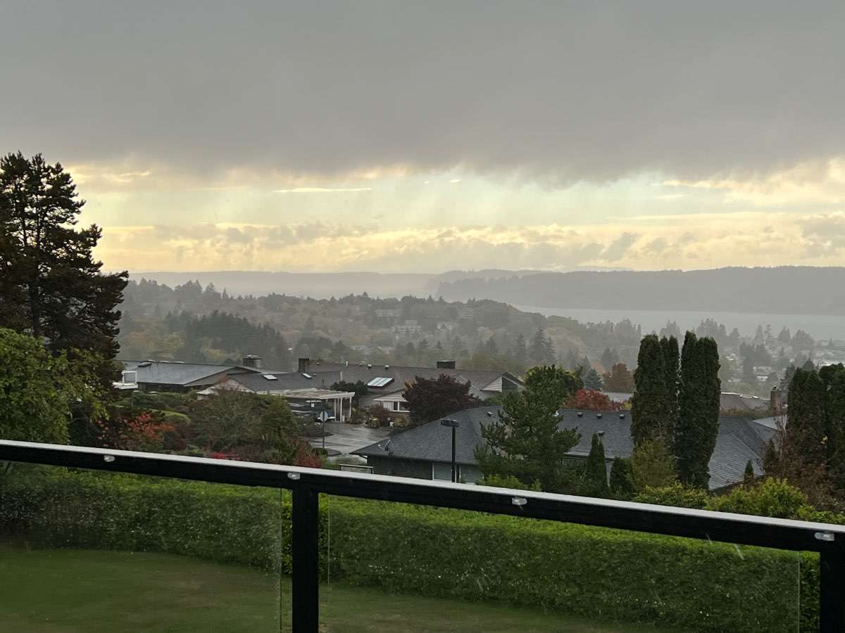
Looks a bit stormy already down at Westport. Should be down there in a couple hours unless trees are over road and block me. Got my car packed with survival crud just in case.
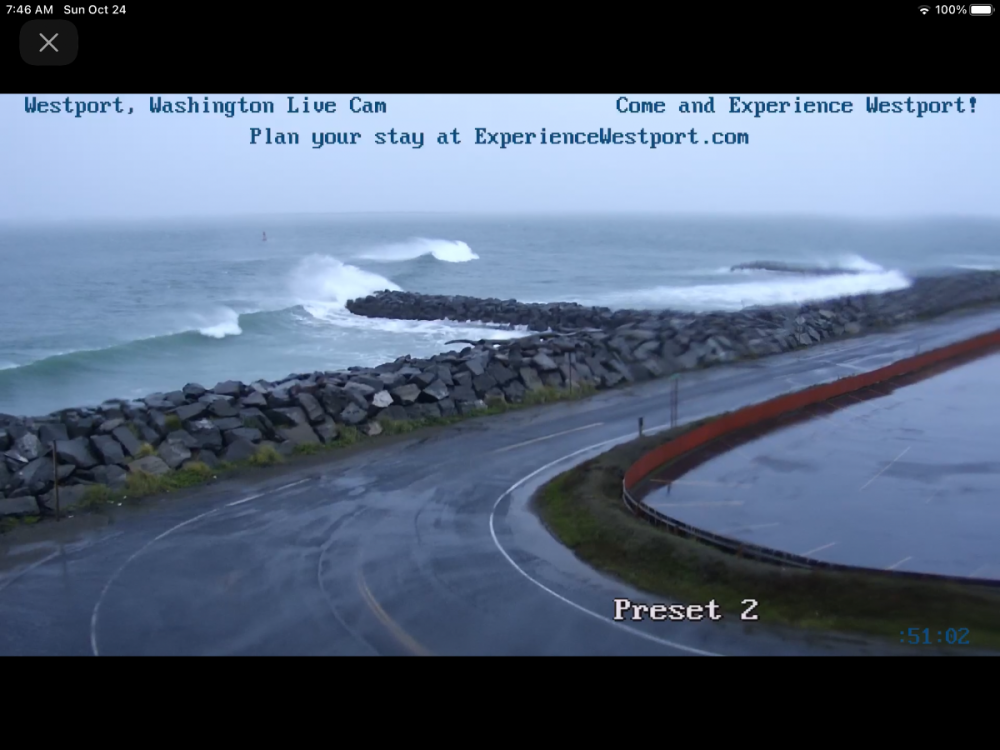 5 points
 -
This is from Gary's blog this morning discussing todays storm and the monster of a storm showing up mid-week. Exciting times ahead, also of note is that LRC cycles in La Nina years tend to be shorter typically less than 52 days. It has snowed in three straight Octobers, and this storm is the type of storm that can do it, but it will be way too warm in this first LRC cycle. When this part of the pattern cycles back through in December, it may very well be a major snowstorm. So, remember these two storm systems as they are in this year's cycling pattern that has started out rather fascinating.5 points
-
D**n, the lake is going to be rocking....50+mph wind gusts and waves up to 16 Feet! Yikes! @jaster220, is this what you were looking for???
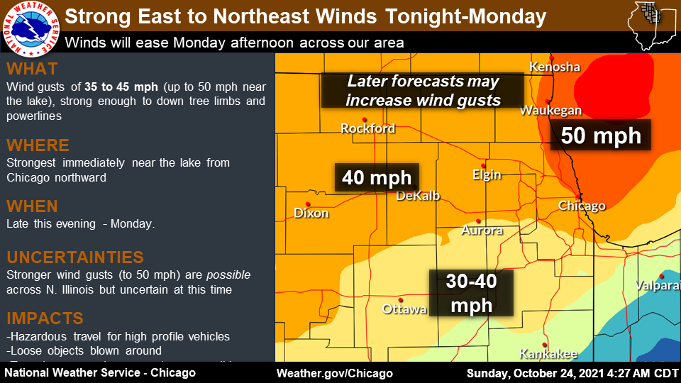
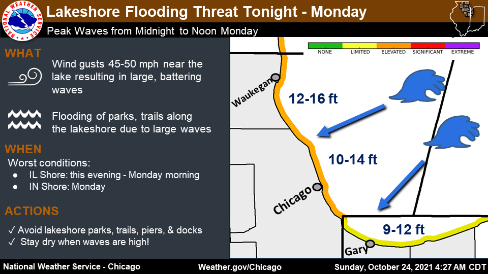 5 points
 -
0z Euro serving up a broad area of 2"+ qpf...
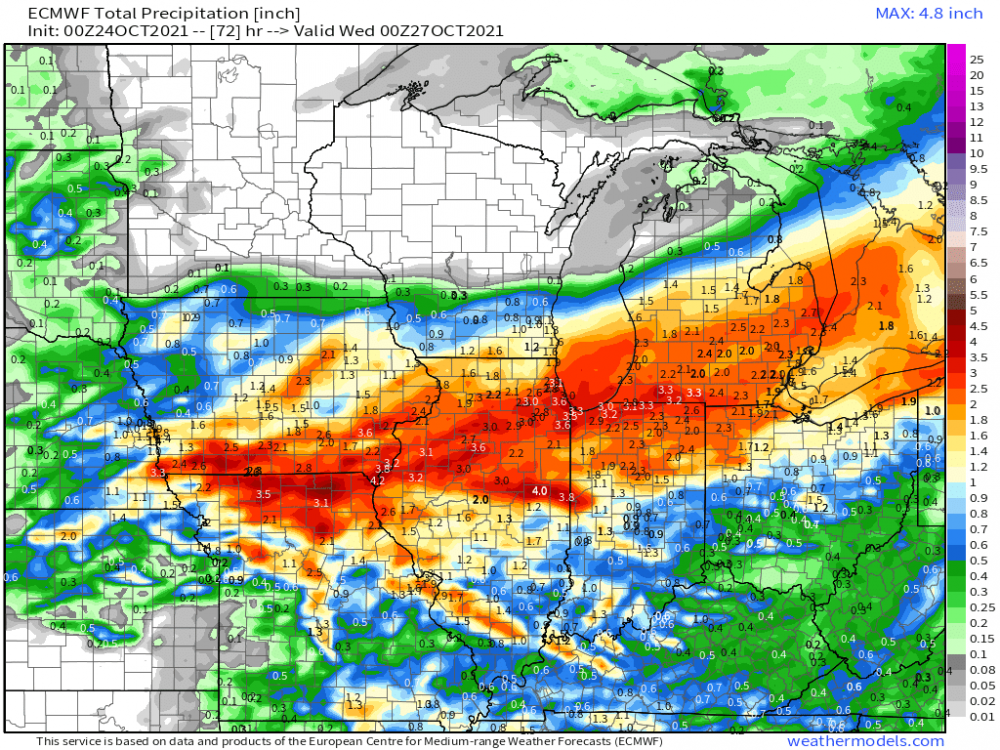 5 points
 -
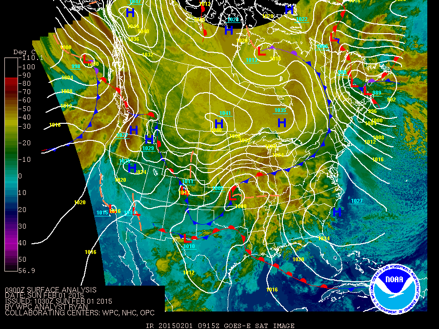
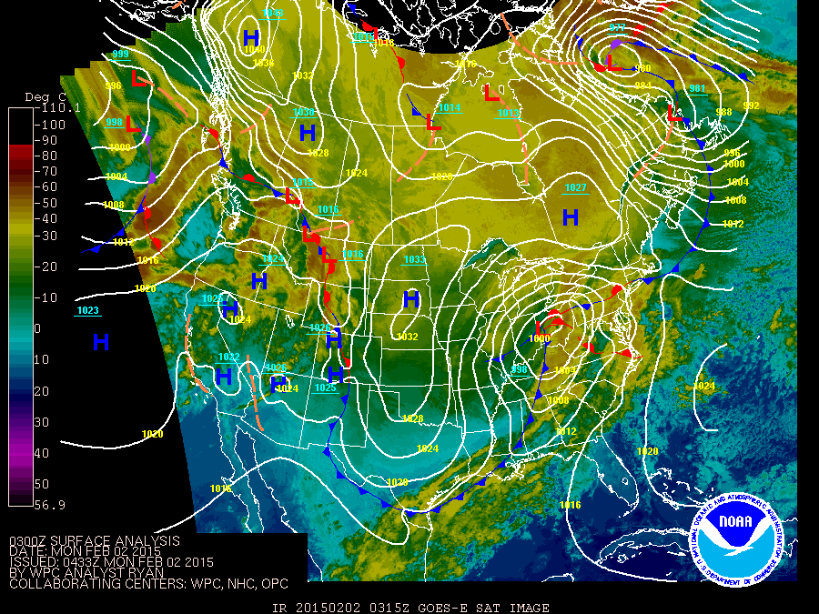
Alright, alright....it's about showtime...convection starting to blow up right along the IA/MO border and producing some drenching training storms. Flood Watches hoisted from near @OttumwaSnomow in SE IA/IL/N IN. Gotta say, this storm track and overall intensity reminds me of the GHD II Blizzard back in Feb '15. There have been similar system as such but that one strikes me as one that could be used as a reference point. Check out this link below...the precip totals look eerily similar. (https://www.wpc.ncep.noaa.gov/winter_storm_summaries/event_reviews/2015/Southwest_Northeast_WinterStorm_Jan2015.pdf) Check this out...I mean, how close can you get??? Banana HP to the north, SLP right over KC and then the backside Lake Effect...I'll see you soon again, I'm sure... SLP tracks over N IN into NW OH back then....models forecasting a nearly identical location! Fascinating stuff right there...
 5 points
 -
You’re way late to the party. I was at a local Lowe’s here at the end of last month and they had their Christmas trees and lights up already. seriously though, when is early too early? Some of these businesses have no shame…. Just like sensational media headlines.4 points
-
It was a pretty good show when that squall line came through this afternoon. I was in Woodinville in area with a lot of trees. Had to dodge multiple falling limbs as I made my day back towards downtown. Came across some lights that were out and then trying to get back into Kirkland was a challenge due to three different roads being blocked by down trees and wires. I largely stayed off the roads after that. There was a lot of roads with limbs and ponds of water on them due to leaves clogging up the grates.4 points
-
I did some searches on Sacramento on Google and now my facebook feed is full of hotel recommendations in Sacramento... insidious!4 points
-
Almost ready! Christmas lights up later this week and snowblower on the tractor on Sunday. Then bring it!

 4 points
 -
Just cruising along.
 4 points
 -
I checked my rain guage about an hour ago and have just under two inches on the south side of Waterloo. I always seem to get more for whatever reason. There's no trees or anything around that I can think of that would give me inaccurate measurements.4 points
-
Defo band is rocking mby. I'm over an inch now with gusty winds.4 points
-
There's a report of 3.8" in NE Lincoln, and that was well before it even finished. Closer to 2" on the SE side. I was a little surprised because I was thinking it wouldn't do much and Wednesday would be our better chance. Not that rain is super exciting or anything, but the past 6 weeks have probably been the most boring stretch of weather since I came here 4 years ago.4 points
-
4 points
-
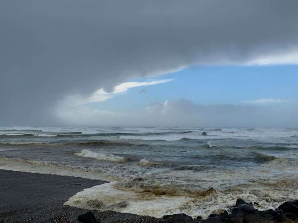
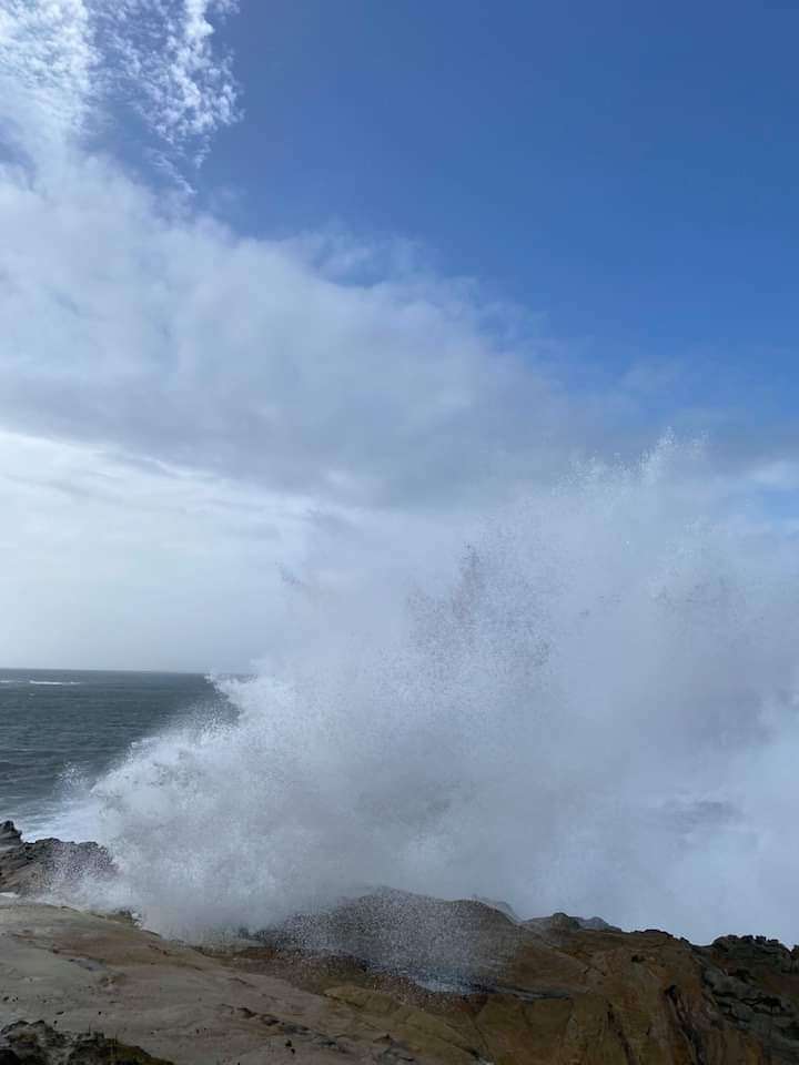
Up to a 43 foot swell 275 miles west of Coos Bay… https://www.ndbc.noaa.gov/station_page.php?station=460024 points
-
45 and its getting windier. Lot of leaves coming down now. So far 0.65" This would be an epic winter storm.4 points
-
New severe box and this time it's for (guess it) Clark County!
 4 points
 -
Over an inch at LNK so far. Probably a little less in SE Lincoln, but currently heaviest rain of the day. I wouldn't be surprised to exceed 2". Edit: Wow absolute downpour. You would think this is a July storm with less thunder, except it's October and 48 degrees4 points
-
Barely a breath of wind here all morning. Inherited this old school barometer from my father in law. Based on readings from nearby nws sites, looks like it’s reading about .15 inches high.
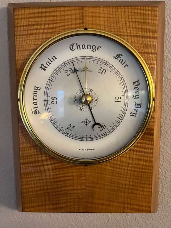 4 points
 -
Don’t think it’s been mentioned, but one of the better recent analogs for this system was early January 2008. I think that one bottomed out around 960mb and tracked a little closer to the coast.4 points
-
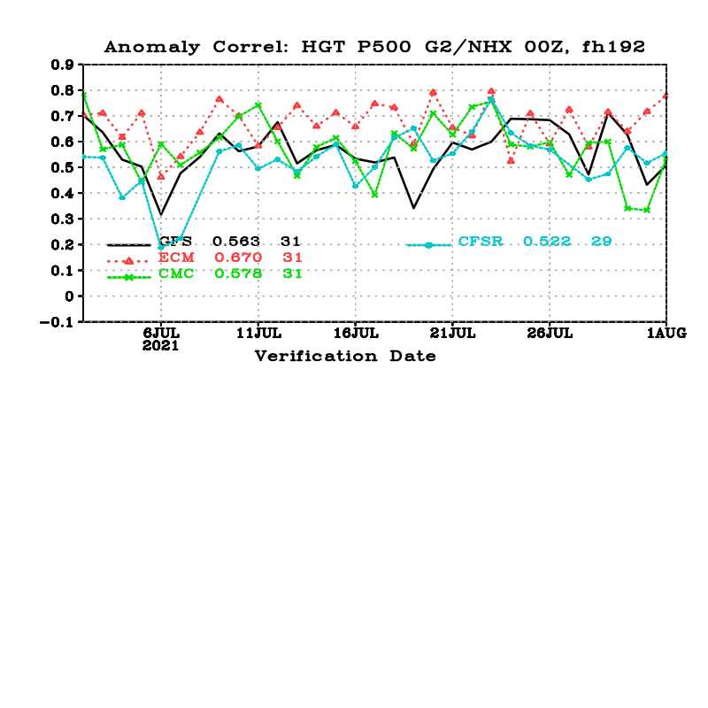
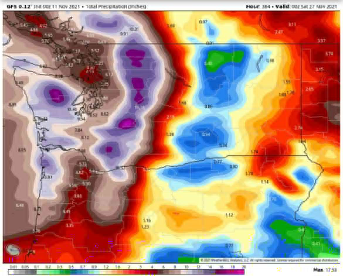
12Z GFS shifted the AR plume a little farther south. Here is the same period on the 12Z run...
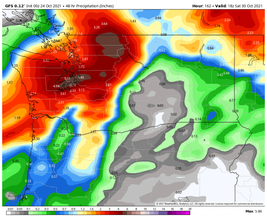
.thumb.png.00ed1f14dbe6afc059fc97b12d1d4dd4.png) 4 points
4 points -
I’ve enjoyed your posts over the past few months. Please don’t start this nonsense again…4 points
-
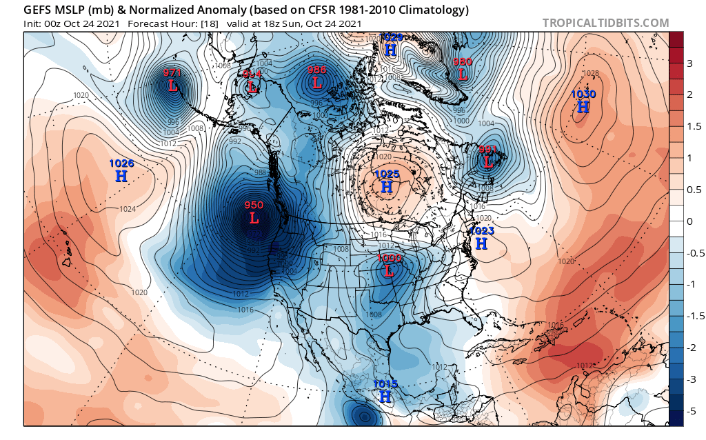
Let's think about this. In February we had a historic ice storm in the Willamette valley, then a historic, unprecedented regional(including BC, AB including an incredibly anomalous lightning outbreak) heat wave in June with 500mb heights many standard deviations above normal, and now in mid-late October within a week two of the deepest lows we've ever seen with the second low for today possibly to become the strongest on record. I see no reason why these highly anomalous and historic events won't carry into the upcoming Fall and Winter months. We shall see. C'MON!!!!4 points
-
The pressure at my house is 29.15", the lowest since February 14th, 2019!4 points
-
It is foggy and 35 here at my house. I went outside and there is no frost here in my neighborhood. However, at GRR they report a temperature of 31 with freezing fog. There was yet another 0.13″ of rain fall here yesterday most of that came in a heavy lake effect rain shower.4 points
-
At this point we have some wind to deal with over the next couple of days, then a big AR event later in the week, and then the prospects for some colder weather during the second week of November. The details on the latter are still sketchy, but the ensembles really like the idea of sharply falling WPO during week two. Very often the first sign of GOA amplification on the way. Pretty dynamic period we are in.4 points
-
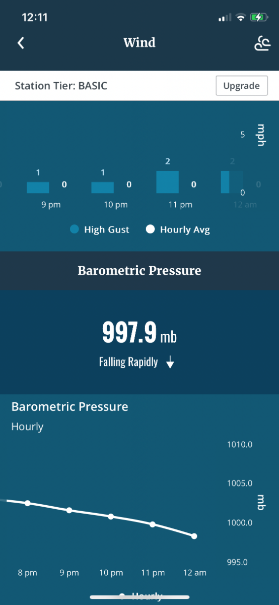
My weather station is in agreement of something Big out there! “Falling rapidly “
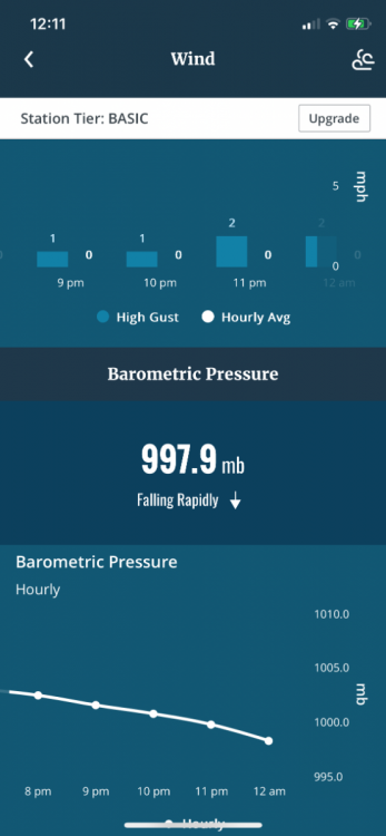 4 points


.png.f94d94e620db3d5ddb22d839de422d0c.png)


This leaderboard is set to Vancouver/GMT-07:00